First Forecast of 2019

I’ve taken some “time off” relaxing and enjoying time with friends and family and I hope you all had the same chance, but the new year is here and it’s time to get back into the swing of things.  Here’s a look at the next 7 days.

Jan 2

Highlights

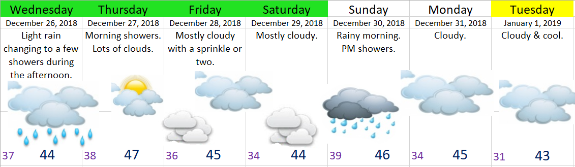
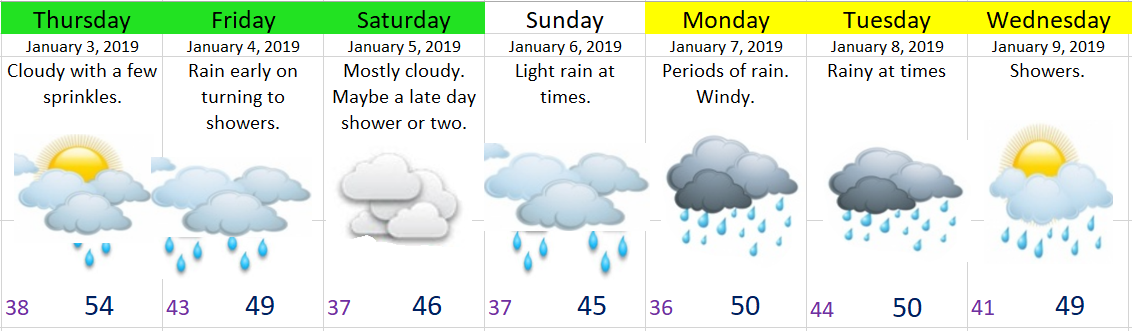
Thursday will be a mostly cloudy day with just a few sprinkles.  More sprinkles and light rain the further northwest you go, so places like Amity, McMinnville, and the Portland area should all have a wetter day than those of us in the mid valley.

There is a greater than usual amount of uncertainty with the forecast for next week.  Currently it’s looking like Sunday – Tuesday will be quite wet with strong winds possible Monday evening and Tuesday.  Showers on Wednesday.

December 26th

The Valley

A quick day after Christmas forecast for you all.  Nothing too exciting heading our way.  Just cool weather with rain at times and lots of clouds.  Basically I don’t see a whole lot of sunshine in the near future for us.

Dec 6


 The Cascades

The recent mountain snow, which I (so humbly) predicted has brought Hoodoo’s base up to about 40” which is awesome news!!  I see at least another 9 – 12 inches of new snow coming between now and Sunday night which will add to our now growing and somewhat respectable snowpack.

Snow levels look to be around 2000 – 2500’ today and tomorrow.   4500’ dropping down to 2000’ on Sunday.   

Snowy pass conditions today, Thursday, and again on Sunday.  Expect spots of ice and snow all the other days as the lack of sun will make it tough for the roads to really clear up.

 That’s all I got, so be safe and enjoy the rest of your week! 

Christmas Break Snow

Some excellent news for the Cascades and ski resorts.  First off, the snow from Thursday’s storm brought the base at Hoodoo up to about 28” which was enough to open the majority of their terrain and with additional snow headed their way I suspect they should have all their runs open any day now.  Mount Bachelor, and the ski resorts on Mount Hood also have most of their runs open.  It’s not a lot of snow up there, but enough to have some fun.

Now for the rest of the good news: it looks like some 16 – 22” of new snow is on the way between now and the 26th with more for the higher locations and even more possibly in the days leading up to New Year’s Eve.  All just in time for Christmas break!!!   If you are a skier, snowboarder, snowmobiler, or just a snow lover than the Cascades will be the place to go these next couple of weeks.


Traveling across the Cascades I don’t see any real good day.  Notice how Santiam Pass looks this afternoon despite being dry all day so far.  With more snow arriving tonight I expect either snowy roads or at least spots of ice each day, so make sure you have good traction (chains, studs ect.), take it slow, be safe, and get out there and enjoy the snow!

Santiam Pass 12.22

Christmas time forecast

Christmas time is here which means this one man forecasting team hasn’t been posting quite as often, but I managed to squeeze some time in today for you all 😉    Before giving the forecast details for the next 7 days I thought I would give a fast recap to our “big storm” from this past Monday night.

The rain totals ended up being spot on with Salem recording 1.86 inches of rain Monday & Tuesday combined; although the majority of this fell Monday night while most of us were sleeping, so it may not have felt like much of a storm.  We also recorded a max wind guest of 48mph very early Tuesday morning which is the strongest we have seen all winter.  Overall not a huge storm, but definitely the “best” storm we have seen this year.


Looking ahead we don’t have any big storms or arctic blasts headed our way.  No chances for valley snow either, just some regular valley rain and mountain snow.

Dec 5

Details

Saturday evening through Tuesday morning will be the wettest period of the next 7 days. 

Notice a lot of yellow highlighting on the extended forecast.  There is a lot of uncertainty for next week, so keep an eye out for changes.  For now this is my best guess.

Big storm headed our way

Dec 4

Big storm details

Clouds continue to increase through the day with steady rain arriving during the later PM hours.  Expect moderate to heavy rain to fall all night long and through the early morning hours.  Strong gusty winds (likely the strongest we have seen this winter) will accompany this rainstorm with gusts 40 to 50mph!!  Rainfall will be very high during this short period of time.  Between now and Tuesday night most places in the Mid-Willamette Valley will see between 1 inch of rain for the “drier” locations and up to 3 inches of rain in the wettest of spots!!!  Keep an eye out for those usual flood prone locations/problem areas.

The rest of Tuesday afternoon will be showery and breezy.  Some showers will be quite heavy.


Rest of the week

Wednesday:  Patchy fog possible; otherwise partly cloudy and dry.

Thursday:  Dry start.  Partly cloudy giving way to late day rain.

Friday:  A few showers.

Saturday:  Showers.

Sunday:  Rainy.

Our driest times this week:  Wednesday and Thursday morning, and maybe late in the day on Friday.


Friday morning update

Real fast update this morning for my loyal followers.

First off, I must say it was a nice surprise yesterday with lots of sunshine.  I predicted a dry day, but I did not figure on so much sun.  A pleasant surprise indeed.


Today’s storm is slowly approaching and should be giving us all rain & a good dose of winds by dinner time, if not a little sooner.  Wind gusts will likely top out around 30 to 40mph this evening.  Highs today around 51°.

Saturday:  An isolated shower two before turning partly/mostly cloudy and dry.  Maybe some patchy fog.  Highs 48 – 50°.

Sunday:  A few showers.  Highs in the low 50s.

Monday:  Partly cloudy & mostly dry.  Slight chance for a light shower.  Chance for morning fog.  Highs close to 50°.

Tuesday:  Very wet and breezy.  Highs in the low 50s.

Wednesday & Thursday:  Rainy and breezy at times.  Highs 48 – 53°.

Friday (the 21st):  Mostly dry & cool.  Highs in the mid 40s.