Looking ahead!!

deep thinker

As this picture clearly shows I’m a deep thinker lol…  Today I’m thinking about the forecast for this weekend and next week as we will continue with both colder than normal weather, and more flirtations with possible low elevation snow. 

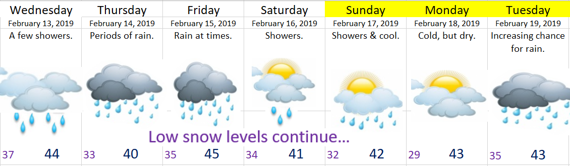
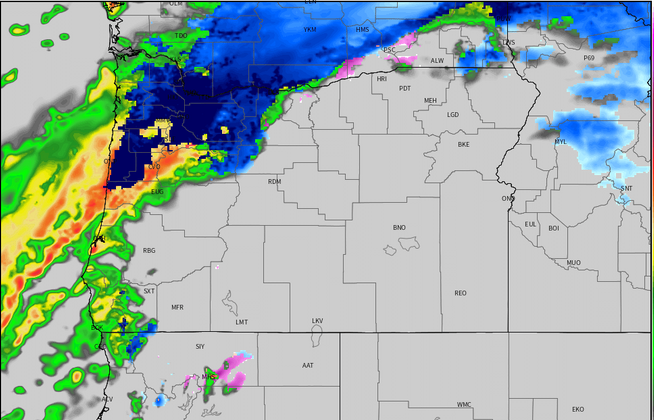
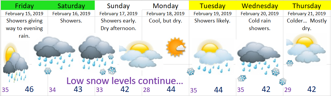
The next 7 days.  Yes, more snowflakes in the forecast, but sadly it will likely be more of the same with some slush or a dusting at best.  Better chance for snow the higher up in elevation you live.

Feb 14

Details

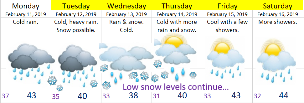
Rest of today:  Breezy with gusty south winds turning us mild (briefly).  Rain moves in tonight with a cold front and we cool right back down.

Friday:  Showers during the day with some steadier rain in the evening.  A few hail/ice pellets showers possible along with some fairly heavy rain showers, especially during the afternoon hours.  Snow levels around 1500’.

Saturday:  Snow level will start quite low (around 1000’) before rising to 2000’ later in the day with a few showers.

Saturday night – Sunday morning:  Another cold air mass surges in during the overnight hours bringing snow levels close to 500’.  I’m currently not anticipating anything real exciting, but the possibility exists that a few snow showers could fall down to the higher hills around town.

Sunday:  After a few rain (or snow showers), skies should clear up leading to a partly cloudy afternoon. 

Monday:  Dry & chilly.

Tuesday & Wednesday:  More chilly weather with rain showers and very low snow levels.

No great chance for snow on the valley floor yet, but if you live 500 – 1000’ you have a decent shot at seeing a light coating to an inch or two this weekend with possibly a little more next week.  Basically our cold and wet pattern is not going anywhere anytime soon.

Happy Valentine’s Day!!

January 2019 Stats

January 2019

(Salem, OR)

I’ve had these ready to post, but they sort of got put on the back burner with all I’ve had going on.  Anyway, better late than never.  🙂

Temperature:

Warmest high temp was 60°  January 10th

Coldest high temp was 41°  January 26th & 27th


Warmest low temp was 48°  January 3rd

Coldest low temp was 25°  January 1st


19 days above normal.

5 day right at normal.

7 days below normal.

11 days with lows at or below freezing.

January averaged 1.84°F above normal.


Precipitation:

Precipitation fell 14 days.

17 dry days.

The wettest day was January 18th with .75” of rain.

We ended the month with 2.93” of precipitation which is only 49% of normal and 3.03” below our normal total precipitation for January.

No snowfall.


A fairly “boring” month weather wise with one other notable highlight worth mentioning: the wind gust to 54mph on January 5th.  Otherwise a very quiet month for weather events.

In summary: January 2019 was slightly warmer than normal, and much drier than normal.

Windy Valentine’s Day

Look how festive I am?  I’ve got pink font just for today.  😉

It’s calm, cloudy, & cool right now, but gusty southerly winds are coming for this afternoon.  Gusts no higher than 40 – 45mph seems like a good bet.  Winds will no last too long and should die off quickly tonight.  I expect showers to fall at times through the course of the evening.  I’ll also have an updated look ahead later this afternoon.  Enjoy your afternoon!

A look ahead & storm recap

Forecast

Looking ahead I don’t see a good setup for snow still.  I don’t see a big warmup either as we continue to stay in this cold and wet pattern for the foreseeable future.  That part of the forecast has worked out very well as February is currently running far below average for temperature.

Feb 12


Storm recap

The past 36 hours have been wild and interesting to watch unfold at least from a weatherman’s perspective.  We had gusty south winds all Monday night and through Tuesday morning.  I’m sure you noticed them.  Gusts to 40mph were reported four separate times at the Salem airport.  Meanwhile areas to our northwest have been pounded by heavy rain causing flooding on many creeks and streams specifically up in Washington, Clatsop, and Tillamook counties.  Here’s what the radar looked like Tuesday morning.  Two things stand out.  First is the heavy rain just to our north, and the second is the heavy snow (in blue) just west of the Portland Metro area.

radar 2.12

I work very hard writing my own forecasts and making my own graphics, but I just don’t have a fancy studio or programs to create nice graphics which means today I’m borrowing from a local professional.  This image is brought to by Mark Nelson over on Fox 12 Oregon.  These precip totals were only through 10am, so I imagine much more fell as the day went on!!  You can clearly see locations to our north and west received far more rain this morning which led to the flooding issues up there.  I’ll try to have some official rain totals later.

Fox 12 precip 10am 2.12

Then there was the gorge where cold air kept snow falling along I-84 all day long.  Here’s I-84 at Cascade Locks from Tuesday morning.

CascadeLocks 2.12

No snow today as you might have noticed here in the Salem area, and that’s primarily a result of just not enough cold air and the rain band stalling a little too far north of us as the previous images revealed.  If the precip band had been directly over us it could have been a different story.  The locations where it did stall saw heavy wet snow fell below 1000′ causing trees to fall and messes like this scene from highway 6 early Tuesday morning in the northern Coast Range.

highway 6 2.12

Some additional proof that snow fell to low elevations Tuesday morning.  Here’s US 26 west of the Portland metro a little ways.  You can see snow had no trouble here sticking down to 778′ and even a bit lower in surrounding areas.  All in all a crazy day!

US 26 snow 2.12

I am sorry about the lack of a good snowfall here, but I’m thinking there’s nothing I can do about it.  Trust me I’m just as sad, and I keep telling myself this must be setting us up for an incredibly huge amount of snow sooner than later.  I mean that’s got to be how it works, right???  After all, Portland has received several inches so far this winter, Seattle is looking at historic snowfall for February, and even as I write this, it’s snowing and 32° in Redding California right now!!!  Sooner or later Salem has got to receive its “fair share” of snow.


Wet & cold…

Quick highlights

Monday:  Cold rain.  No issues.

Monday night – Thursday morning:  During this period of time we will be having near constant precipitation as a couple of storms essentially stall directly over the region.  Total precip between now and Thursday will be in the 3 to 4 inch range!!!  That will cause some localized on our smaller creeks and streams and some low laying areas.  No concern regarding the bigger rivers.  Notice I still have lots of snowflakes on the extended forecast below indicating that we will be “flirting” with snow much of the week, but for now I’m still leaning towards us just getting plain rain this week.

Beyond Thursday we stay colder than normal and wet.

Feb 10

Extra Details

Predicting snow around here truly is a pain in the, well you know…  Anyway, there are so many factors that have to be considered, and tonight I have some more “game changers” for the Tuesday – Thursday timeframe which could give us some heavy wet snow.

Some of the forecasting models indicate steady and heavy precip could drag the snow level down to the valley floor.  This has happened before.  It’s how we got that snowstorm in March several years ago.  The problem with this setup is everything has to come together just right or else we end up with only cold rain.  Check out this simulated radar image for early Tuesday morning.  It shows in the blue some very heavy snow falling in parts of the valley while the rest of us sit under a cold heavy rain.  Hard to say what will happen…. 

simulated radar Tue snow

Of course there are countless other maps and charts I look at, but this one I felt did the best job of showing how borderline we are going to be this week with seeing or not seeing snow.  Something to keep in mind.  Look for another update by Monday night as I should have a better idea by then.

Enjoy your Monday 🙂

Snowy Cascades

Huge week coming for the Cascades with 3 to 7 feet of new snow above 2500’ by the time we reach next Sunday.  This will dramatically improve snowpack levels.  I see no good day to travel over the Cascade passes this week, so if you’re headed over there just keep in mind conditions will be very poor and chains or traction tires will be a necessity.

Snow levels will rise briefly to around 2000’ through Monday evening before coming back down to 1500’ (maybe lower) Tuesday. 

Wednesday and the rest of the week:  Snow levels will fluctuate between near the valley floor and 2000’.  We are staying in this cold weather pattern for the foreseeable future.

The Coast Range will be in and out of the heavy wet snow zone for much of the week.  Best travel day looks to be Monday.  Tuesday & Wednesday in particular look to be the snowiest/ most treacherous. 

Here’s a link to the road cams all across Oregon.  A great tool for keeping tabs on the latest weather conditions.

https://tripcheck.com/Pages/Road-Conditions?curRegion=0

Rainy Monday

It’s cold out there, clouds are overhead and there are rumors of snow all around.  Well, any snow we see this evening will be very brief and it will melt before any of us even wake up Monday morning.  So no need to worry.  South winds will make it tough to stay cold enough for snow, and in fact the winds will steadily warm us up overnight.  By Monday morning we should be around 40°.

Here’s a link to the latest radar image courtesy of Fox 12 News (and Mark Nelson) to help you keep track of where the rain and snow is falling.

Details

This evening:  Snow, changing over to a mix, and then just plain rain late tonight.  No accumulating snowfall below roughly 500′.  Anyone living close to 500′ and higher could see a quick inch before it melts later on with the incoming rain.

Monday:  Cold rain.  No issues.  Snow level will be all the way up to 2000′.


I’ll have a fresh look at the week ahead later this evening, but four things to know now regarding our week ahead:

It will be very wet.

Widespread valley snow this week is looking a lot less likely at the moment.

We will be staying in a colder and wetter than normal pattern for the foreseeable future which means you won’t have to go very high up in the hills/mountains to find snow and a lot of it.

The mountains are going to get absolutely dumped on with snow.  Especially above about 2500′.