Springtime weather

I hope none of you are feeling short-changed by the lack of posts lately; although, one could say you’re getting what you paid for 😉   lol

Anyway, I hope you all have enjoyed the outstanding weather lately as today is now the 4th day in a row with highs in the 70s!  More typical spring weather is on the way with a mixed bag of both sunny days and showery/rainy days.

March 20


Details

I’ve got lower confidence in tomorrow’s forecast as we will be in a weird set up with showers coming in off of the Cascades (moving east to west) which is both very rare for our area and why I’m not sure how it will play out.  Bottom line is be prepared for showers tomorrow and you will be just fine.

Friday may initially start off dry, but don’t let it fool you.  Rain moves in around lunchtime and will last the rest of the day.

Tuesday could likely end up as mostly dry with just an isolated shower or two.

No more 70s for the foreseeable future.

No more frosts or freezes.  We are done with the cold weather which means it’s safe to begin planting if you have not done so already.

Sunnier days ahead

After almost 5 weeks of colder than normal weather, hard freezes, and a number of little snow events, we are quickly making the transition into milder spring-like weather.  As of 2pm it was 55° in Salem!  This coming weekend will feature the warmest weather we have seen since October with highs in the 60s.  Spring is coming!

March 11

A few details

It’s possible both Thursday and Friday mornings start off frosty; however, once we get through this week I doubt we see any more frosty mornings until next fall – a sure sign that the seasons are changing.  🙂

Tuesday:  Lots of clouds, a few sunbreaks, showers, and even some hail is likely in a few places.

Wednesday:  Partly cloudy with a very slight chance of an afternoon shower; otherwise mostly dry.

Thursday – Saturday:  Cool mornings with lots of clouds around.  These days have the potential to be warmer, but for now it looks like cloudy skies will keep us in the 50s.

Sunday & Monday:  Warm & sunny March weather.


February 2019 Stats

The February 2019 stats are in for the Salem Airport, and spoiler alert, they are cold! 😉  I will have to do some digging (so don’t quote me on this one), but I believe this month broke a long string of warmer than normal months going back to last March!!


Temperature:

Warmest high temp was 54°  February 1st  

Coldest high temp was 37°  February 5th

Warmest low temp was 41°  February 1st and 12th

Coldest low temp was 24°  February 6th


6 days with high temperatures below 40°.

16 days with lows at or below freezing.

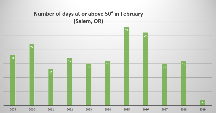
Only 2 days reached 50°.  More on that later.


4 days above normal.

2 day right at normal.

22 days below normal.

February averaged 4.39°F below normal.


Precipitation:

Precipitation fell 23 days.

5 dry days.

The wettest day was February 11th with 1.15” of rain.  A new daily record for that day.

We ended the month with 7.09” of precipitation which is a whopping 155% of our normal February total of 4.56”.


Snowfall

Snowfall is tricky due to the sad fact that Salem no longer keeps official snowfall records and has not since 1995 “insert extremely sad face.”  The National Weather Service (to the best of my knowledge) relies on public reports from around the area when it comes to snowfall.  I tried finding the average of the various city-wide snow reports (including my own) to come up with our monthly total. 

As you know, Salem avoided any sort of big snowstorm.  Instead, through the course of February we had several minor snow events all adding up to a monthly total of 6.25” of snow (remember that’s the average from all parts of the city).  My home (at 475’ in elevation) located in south Salem was at the higher end with just over 8”.  Hard to believe we got that much when it only fell 1 or 2 inches at a time and it usually melted away by lunchtime.

Regardless, it all added up to an average of 6.25” giving us our snowiest February since 2014.


Summary

February 2019 goes down in the books as a much colder than normal month (4.39° below normal) with only 2 days with highs at or above 50°.  I’ve charted out February days reaching at least 50° over the past 11 years.  You can see just how remarkable it is to have so few 50+ degree days.

Feb days at or above 50 SLE

February 2019 also goes down as a very wet month with 155% of our normal February precip.  Additionally, February 2019 was a very big month for the mountain snowpack with several feet of snow falling in the Cascades.  As of today, Hoodoo ski area has a 105 inch base with a majority of that falling just over the past 5 weeks.  Overall, a very chilly and wet month!


A cold & snowy March day

I know I’ve said this before, but I need to claim my victories and give myself a pat on the back when I can, because it doesn’t always work out this well lol. 😉   I’m very happy with how the forecast is turning out so far.  Very light (and spotty) sleet & ice early this morning transitioned to snow around 10am.  Since then we have had snow or a snow/rain mix falling nearly all day long with temperatures holding steady in the mid 30s.   

As of 5pm, Salem’s high temp was 37°.  I imagine we are done “warming up” for the day and we should gradually begin cooling back down from here on out setting the stage for the next (and perhaps better) opportunity for accumulating snow.


What’s next?

We get a bit of a break this evening with only a few scattered snow showers.  Tonight we eventually cool off to around 32 – 34°.  Around 4 – 7am a more organized batch of snow showers will roll through.  This could give anyone a quick inch or so of snow.  It all depends on where the heaviest showers end up, but don’t be surprised to see snow tomorrow morning.

During the day Thursday expect more rain & snow showers, but roads should be fine once again.

I don’t want to be known as a broken record, so I’ll just tell you that Thursday night and Friday’s weather will be a near perfect copy of the weather we see tonight and Thursday.  😉


Saturday – Monday will be dry and sunny.  Still chilly, especially in the mornings, but with how it’s been going lately I suppose we should take what we can get.  Lows 28 – 32° and highs 48 – 53°.


Quick update

It’s cold outside and getting colder, but it’s super dry.  I’ve checked both the radar and satellite loops and neither one shows a lot of moisture at all.  This means very little ice or snow tonight and tomorrow morning.  It doesn’t take much to make roads icy, so still be careful tomorrow morning and be ready for delays just in case, but I’m really not expecting very much to fall.  My updated forecast for now through 10am: nothing to 1 inch of snow and ice tops.

Wednesday afternoon and evening:  Precip will increase dramatically during the afternoon hours and much of that will fall as either a rain/snow mix or wet snow.  As stated in my previous forecast: no sticking snow until 5 or 6pm at the soonest due to the warmth of the day.  After sunset anyone could pick up a dusting or so.  More snow the further east in you live  (ie. Stayton, Scio, Silverton ect.)

Wintry weather update

Here we go again with more chances for snow only this time it’s March.  I’ll get to all the fine details soon, but first the extended forecast.

March 5

In a nutshell I see several more opportunities for wintry weather before gradually warming up Saturday through Monday.


All the details

Tonight we slowly cool off back close to freezing.  Just like last week’s little snowstorm I’ll keep a close eye on the temperatures as they will be an important indicator as to what falls from the sky later on.  Regardless of temps, precip should arrive around midnight (give or take an hour or two).  Precip will be very light and spotty at first as we have very dry air for it to overcome.  Depending on how thick the cold air above us is we could see freezing rain, sleet or snow.  I’m leaning towards a mix of all three, but more ice than snow as we will be right in the “battle zone” of the different air masses.

Precipitation will be very light:  This looks like a drier version of last week’s storm that dropped 1 – 2 inches of snow.  I’m going for a dusting of snow with areas of ice.  Could be a messy early morning commute.

It’s March now which means even on a cloudy day the angle of the sun and it’s increased energy is enough to melt snow and ice off of roads from roughly 9 or 10am to 5pm), so travel during most of the day should be just fine even if snow is still flying through the air.

Cold air will be rushing in behind this storm giving us our second shot at snow Wednesday night.  This is manly for the east side of the Willamette Valley.  Basically the further east you live the better chance you have at seeing an inch or 2 of snow Wednesday evening/night.

Early Thursday morning a batch of heavier showers looks to roll in sometime between 4am and 10am.  Temps are forecast to be right around 31 – 34° which means we could pick up a quick inch or two of very wet/slushy snow to start our day off.  More rain and snow showers will fall the rest of the day.  Just like Wednesday, there should be no travel concerns past about 10am.  The rest of the day should be just fine.

Same story for Friday.  Morning snow will give way to a few afternoon rain showers.

Beyond Saturday it looks like we have a brief warm up and dry break coming for Sunday and Monday.  If this holds true it will feel very nice after this cold week.


THE CASCADES AND BEYOND

Tonight through Saturday morning I expect snow at times in the Coast Range, and plenty of snow in the Cascades even during the daytime up there above 2000′.  The Gorge will also be messy, so if you plan on traveling through any of these regions be prepared for wintry weather with snow and ice.