End of July outlook

I hope you all are having a fantastic summer!  I’ve neglected to post for quite sometime; although I typically don’t post very much during the summer months as the forecast is usually pretty straight forward and simple.  This week’s forecast is no exception.

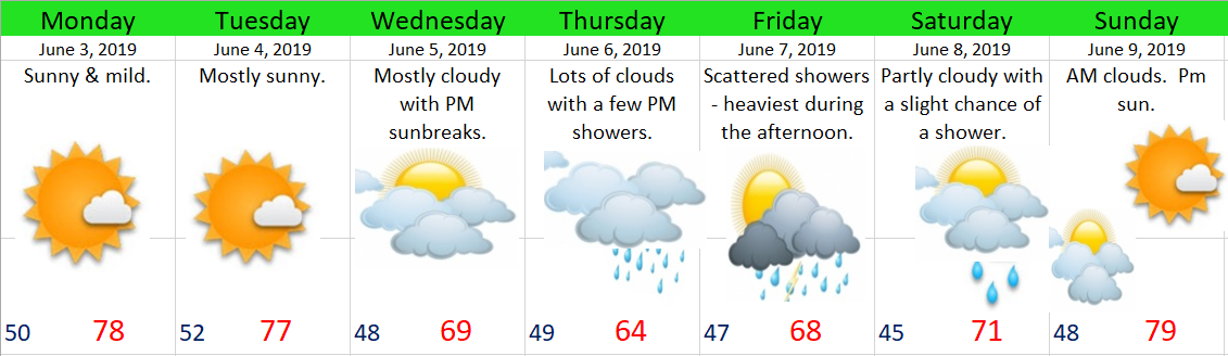
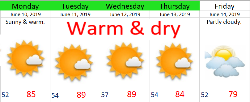
Sunny & warm weather will dominate the next 10 plus days as we have settled into a very stable summertime pattern.  Highs will generally be in the upper 80s with lows dipping down between 55 & 59°.  Basically some good old fashioned western Oregon summer weather right there!

This picture pretty much sums up the forecast for the next several days…

forecast image 7

Like normal, there is an exception to the forecast, and in this case the exception is Tuesday & Wednesday.  Both those days will end up more on the partly cloudy side of things.  Still mild & dry, but with highs staying closer to 80 or 81°.

There you have it!!  On the home front I have no exciting garden updates for now, but if things go as planned I should have some little watermelons growing here in the next week or so.  🙂

Thunderstorms this afternoon

Showers and thunderstorms are likely this afternoon.  The eastern Willamette Valley in particular has the highest chance, but with enough sunbreaks today I believe just about anyone could get in on the “action” today.

Thursday:  Cloudier than today with another chance for showers and thunderstorms.  Highs in the upper 60s.

Friday:  A few showers with plenty of of sunbreaks in between.  High around 70.

Saturday:  Lots of clouds in the morning with increasing sunbreaks as the day goes on.  Highs in the low to mid 70s.

Sunday:  Mostly sunny with a chance at some late day thunderstorms.  Highs in the mid 70s.

No fancy graphics or pictures today, and honestly I haven’t looked into the forecast for next week much either as I’ve been quite busy helping to get things ready for my sister’s wedding this weekend!    🙂  🙂  🙂  🙂  🙂  🙂  🙂

Cooler weather & garden update

Cooler June weather has set in and will stick around for the next 10 days or so with lots of clouds (especially during the morning hours), and even a few days with showers.  More details below.

On the home front I’ve been working in and maintaining my garden.  I’ve got lettuce, tomatoes, peppers, cucumbers, and of course watermelons again.  The lettuce in particular has really taken off.  Here’s what the garden looks like as of today.

As far as the weather goes, it looks like we have a slight chance for showers on Thursday, and then again from Tuesday through Friday of next week.  Not a washout by any means, but showers appear to be likely each of those days.  I will have more details concerning next week’s shower chances in a day or two, at which time I will try to give another update.

In the meantime, for visual learners (like myself), here’s the extended forecast graphic taking us through next Wednesday.  Perhaps the best part of this forecast is how the nicest weather looks to fall on Saturday.  Pretty convenient right?? 😉  Now if only that could happen next Saturday as well……..

June 19

Sunbreaks & Showers

The ingredients are coming together for some afternoon showers and thunderstorms today.  As always, the more sunbreaks we get the higher our chances go for seeing a thunderstorm, so don’t be surprised if you get caught in a downpour with very heavy rain and or small hail.

The other highlight worth pointing out is the very chilly weather this “storm” has brought to our area.  It was even cold enough for snow this morning up at Timberline Lodge.

timberline snow 6.7

Extended Forecast

On Saturday we dry out and warm up a little.  There’s still a very slight chance of a late day shower, but the chance is very small at this point.

Sunday we warm up into the low 80s kicking off a string of very warm/hot days.  High temps on Tuesday & Wednesday will likely reach the low 90s!

If you like cool weather than enjoy it while it lasts, because summer is on the way.

Have a great rest of your Friday!!

Extended Forecast

7 Day Forecast

June 3

Highlights

Biggest highlight are the showers Thursday and Friday which have the potential to be quite heavy, so a good soaking seems likely on at least one of those two days.


Completely free of charge, I have a special look into the following week.  It appears Monday will kick off a stretch of several very warm days.  This has been well advertised for awhile now on those fancy weather models I look at, and I can say with a good deal of confidence that next week will feature the warmest weather we have seen this year. 

June 3 special


Slight chance for an evening shower

Numerous thunderstorms have developed over the Cascades this afternoon, and the steering flow aloft (in layman’s terms – the direction of the wind up where the planes fly) is from the east meaning these storms could impact us tonight.  The chance is slim, but don’t be shocked if a storm or shower rolls into your neck of the woods.

If you want to track the storms yourself feel free to click on this to see the latest radar loop.

Warmer days ahead

A real quick forecast this morning before I head out the door.  Basically mostly sunny and dry for at least the next 8 days.  No chances for rain or showers.

may29

The one exception to our dry weather will be up in the Cascades and Central Oregon.  Isolated PM thunderstorms are possible each day from now through Saturday.  Something to keep in mind if you’re looking to hike or camp out that way.

Happy Wednesday!