We have some strong showers and even a few thunderstorms drifting around out there, so keep an eye to the sky over the next couple of hours.
Same sort of weather pattern tomorrow.

We have some strong showers and even a few thunderstorms drifting around out there, so keep an eye to the sky over the next couple of hours.
Same sort of weather pattern tomorrow.
A quick update before you head out the door this morning as we have a chance for showers and maybe a few thunderstorms today.
This morning: The possibility for a few regular – plain old showers exists through about 9 or 10am. Very slight chance for a thunderstorm during this time.
10AM – 4PM: Should be mostly dry, with lots of sunbreaks. With the sun out we could easily get into the 80s today.
After 4PM: Chances for thunderstorms and showers goes up. No guarantees of course (it’s Oregon after all), but a fairly decent chance for our standards.
These regions will almost certainly experience storms today. In fact, there are already storms firing up near and south of Bend now.
Sunday through Tuesday of next week looks showery. Not a washout, but definitely wet at times.
Remember to follow me on Instagram as I post occasional updates on there, especially when I’m on the go and away from the laptop.
https://www.instagram.com/bryanweatheralerts/
Have a great day!!!
I’ve got a brand spanking new forecast out for the first week of September 2019. Check it out!! 😉

Completely dry now through Wednesday evening.
Chance for showers and even thunderstorms very early Thursday morning through Friday morning.
Somewhat lower confidence for next weekend’s forecast, but at this point Saturday is looking all dry.
Sunday and next Monday are looking showery – specifically Sunday evening through Monday.
Bottom line: If you have outdoor projects requiring dry weather then the first half of the week is your best bet. I’ll have another update in a day or two with more details on our thunderstorm chances mid week, and on the shower chances for the weekend.
Take care and a have an enjoyable Labor Day!!
You don’t need a weather forecast to let you know that today is going to be a hot 🙂 The reason I’m giving a quick update is due to the slight chance for thunderstorms and or a few light showers everyone has tonight through tomorrow morning.
The chance for a shower or storm is small, and there’s a possibility many of us won’t get anything, but the chance exists which means I’ll be keeping an eye to the sky.
These storms will not necessarily bring a lot of rain with them which means the threat for wildfires getting started by lightning strikes is a bit higher than normal. Hoping that does not happen.
In other news, the city of Astoria set a new record high temp yesterday of 91°F. The old record was set way back in 1894 (125 years ago). Here in Salem we reached 100° which was one degree shy of tying our record high for the day set back in 1935.
Enjoy the heat!!
We have some rain showers on tap for today. Hard to say exactly when they will arrive. My best guess is for showers to move in between 10am and noon and last on and off through the rest of the day.
A few of our showers could be rather heavy with maybe a couple rolls of thunder mixed in.
Tomorrow through at least most of next week will be dry, so don’t worry about this being the start of our rainy season. It’s looking like a one and done type of storm for today.
This summer has no doubt been cooler than a number of our more recent summers, but all & all still plenty of warm & sunny days, and there’s a benefit to our cooler and slightly wetter summer, and that’s the lack of wildfires.
I’ve noticed, and I imagine many of you have noticed the lack of thick smoke in the air both at the surface and far overhead like we have seen on so many occasions over the past few summers. Definitely a lot more blue skies and a lot less haze this year. Also, to the very best of my knowledge there are no major wildfires burning in the Cascades or Central Oregon for that matter which is a huge change from recent summers.
So a “cooler” summer really isn’t too bad with all things considered.
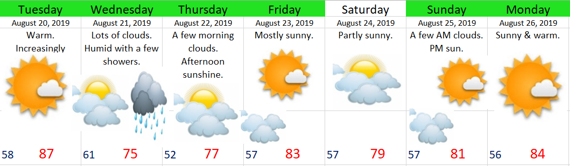
Tuesday: Sunny with increasing clouds & humidity later in the day.
Wednesday: Lots of clouds around, muggy with a few showers. Some showers could be rather vigorous. Maybe even a clap or two of thunder.
Thursday: A fairly cool start to the day with lows dipping close to 50°.
Friday: Warm & sunny.
Saturday: Slightly lower confidence Saturday (as noted by the lack of green highlighting). For now I’m leaning towards a partly sunny day with highs around 80°. There’s a weak little “storm” (or more accurately a batch of clouds) I’m watching which could ruin that forecast and keep temps down closer to the low 70s.
Sunday & Monday: Warm with sunny skies!
Beyond next Monday: Looks warm & dry as we head towards the end of August.
I’m sure you all are waiting at the edge of your seat for this 😉
Are you ready?!?!? I’m pleased to announce that Bryan Weather Alerts is expanding to the world of Instagram and Facebook!!!!!!!
LOL…. Okay, so it’s maybe not that exciting to you, but I’m thrilled!! The Facebook Page in particular will be a great place for all of you, my incredible followers, to post awesome weather related photos for the purpose of sharing with others, for using right here on the website in updates, and on occasion, use on the Instagram Page. This will be especially fun and useful during storms and snow events. 🙂 You can find the page right here: https://www.facebook.com/Bryan-Weather-Alerts-105605014141422/
Showers and thunderstorms are quite likely today through tomorrow morning just about anywhere in the western half of the state. Depending on your point of view it could be a very fun 24 hours or so around here. Not everyone will see a storm, but just about everyone should see a few rain showers.
A quick look ahead shows no sign of hot weather returning to our region through at least next week. Once we get through Saturday I don’t see any signs for more rain next week either. What I do see are lots of high temps ranging between 77° and 84° with lows dropping into the mid 50s each night. Basically just more regular partly cloudy to mostly sunny weather with nothing extreme, too hot, or exciting once we get past today’s storm potential.
Enjoy and be safe!!
