December 2020

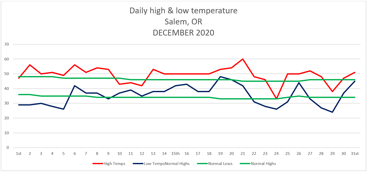
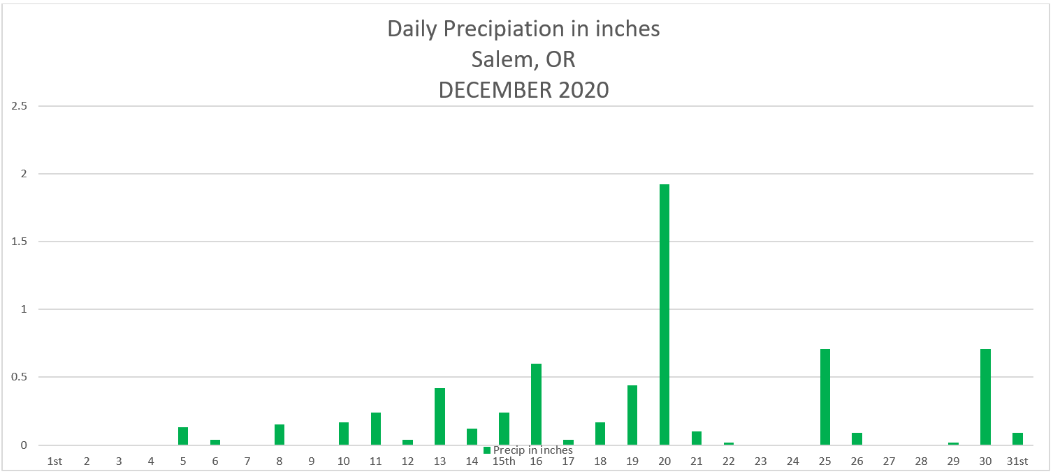
Here are the December 2020 states for Salem. We ended December slightly drier than normal with 6.45″ or 94% of average for the month. On the temperature side of things we ended up being quite a bit warmer than normal overall averaging 2.48° above normal.. Yes we had some very chilly days right around Christmas, but generally we stayed on the warmer end of things.

Warmest high temp was 60°  December 21st

Coldest high temp was 33° December 24th

Warmest low temp was 48° December 19th

Coldest low temp was 24° December 29th

11 days with temps falling at or below freezing.

21 days with measurable precipitation.

The rainstorm on the 20th brought 1.92 inches of rain to Salem (our wettest day of the month) and was probably the biggest and really the only highlight of what ended up being a rather boring month as far as weather action goes. The mountains continued to pick up just enough snowfall through the course of the month to allow for plenty of skiing opportunities over Christmas break. A huge plus for that industry.

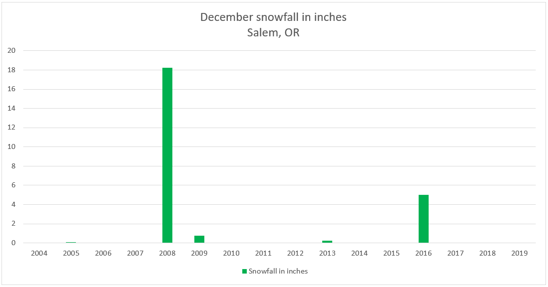
As far as snow goes once again we went another December without any snow here in Salem. Last spring I posted these statistics showing total snowfall per month over the past 10 years for here in Salem.

Feb:  19.25″

Jan:  6.9″

Mar:  6.05″

Dec:  5.25″

Nov:  0.35″

Interesting to see how February has been our snowiest month on average over the past 10 years and how January just barely beat out March for second place. This has not historically been the case. Hard to know if this is a new norm with more snow falling during the end of winter versus the middle, or if it’s nothing more than a temporary trend. Either way one would think that sooner or later we would score a December or January snowstorm….

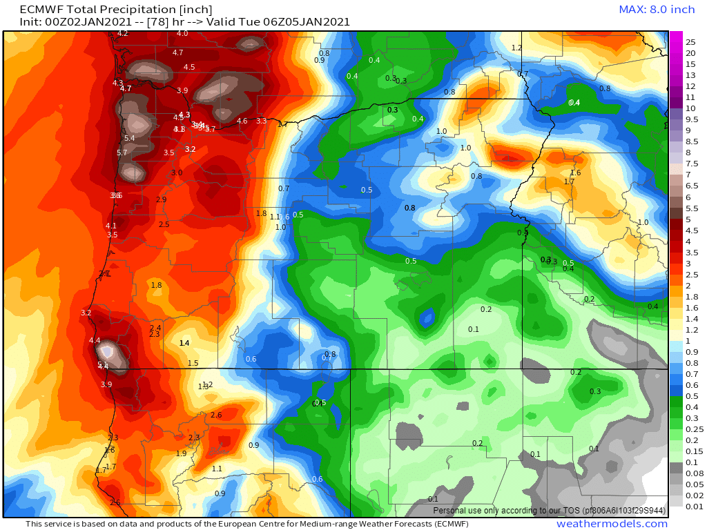
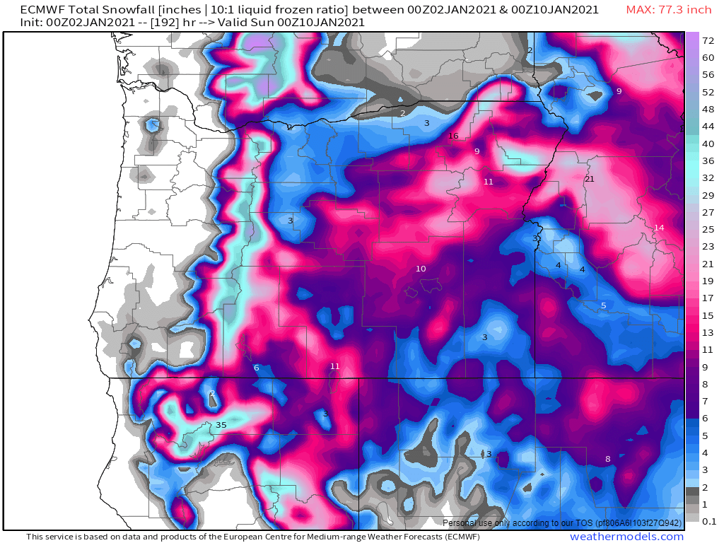
Looking ahead, January has already started off on a very wet note and that appears to continue. I suspect the mountain snowpack will build quite nicely too during this time.

Happy new year, and here’s to a fun, healthy, and safe 2021, and if possible a nice January snowstorm 😉 🙂

An early January washout

2021 is starting off on a stormy note. For starters the next 12 to 16 hours are going to be quite windy. Gusts of 35 to 45mph seem likely for the mid Willamette Valley with higher gusts of course along the coast.

The rainfall will be significant over the next few days as well. Nearly 2 inches of rain should fall now through Sunday.

The daylight hours on Sunday will bring a nice but brief break in the rain before more rain moves in Sunday night. Monday’s going to be another soaker with an additional inch of rain falling with that system. For all the visual learners out there (like myself) I have a chart showing these estimated rain totals for now through Tuesday morning.

The main take away is it’s going to be very wet. The rest of the week looks wet too with another storm moving in on Wednesday and I’m watching for the possibility of another storm coming in next Friday or Saturday. An active start to the new year for sure.

THE CASCADES

Lots of snow coming up for the Cascades as shown above. I’m forecasting at least 3 feet for most of the ski resorts by the end of next week – maybe even more.

THE COAST

The final highlight for this coming week will be the very large swells and waves out along the coast. Waves should reach heights of at least 30 (if not higher) every day now through Wednesday. An impressive stretch of large waves out there should you have the opportunity to get away and go storm watch! 🙂

Have a nice weekend and enjoy the stormy weather!!!

Super fast update

I apologize for the lack of updates. It’s been a busy, but fun week with family and friends. We had a chance to enjoy the snow up in the Cascades, and then just yesterday we had the opportunity to travel to the Oregon Coast for the day. Beautiful weather over there yesterday!!

Highlights

1.) Several days ago I mentioned the possibility of low snow levels today. I stated that I wasn’t too excited about anything happening, and sure enough today we have nothing but cloudy skies and some chilly air – nothing more….

2.) Tomorrow will be wet, especially during the afternoon hours with a period of moderate to heavy rain moving in and some gusty winds.

3.) A few showers Thursday

4.) Friday will likely start off mostly dry before rain moves in late in the day.

5.) I should have a more detailed outlook in the next few days, but the main takeaway is that January will be starting off on a very stormy note with several rounds of strong winds, lots of rain, and copious amounts of mountain snow beginning Saturday and lasting through the at least the first 9 days of the month. Check out the estimated total precip for now through Saturday January 9th. 4 to 5 inches of rain for the Mid-Willamette Valley with up to 10 inches in the Coast Range! Much of this is expected to fall as snow up in the Cascades. We are looking at maybe several feet of new snow next week for the ski resorts. Busy and wild times are coming!!!

Christmas 2020

It’s Christmas Eve! I hope you all are doing very well!! It’s freezing cold outside. As of 2PM it was still only 32 degrees here in Salem!!!!! Tonight will be cold as well with temps falling back into the upper 20s across the valley.

Highlights for the coming week

1.) Christmas day is going to be cold with a drippy/wet afternoon. Not cold enough for snow (or ice) this time – just a cold light rain for us here in the valley. Watch for spots of ice due to the freezing fog tonight and Christmas morning as temps will be below freezing again. Temps SHOULD rise above freezing just before the rain starts tomorrow, so at this time I’m NOT expecting any freezing rain issues.

2.) The Gorge should see snow both tomorrow and again on Saturday, so take note of that if you need to head over I-84.

3.) Saturday will be rainy at times and breezy with several inches of mountain snow.

4.) Sunday should be mostly dry. Monday will totally dry, but quite cold.

5.) Another storm comes in Tuesday of next week. Don’t get too excited, but I’m keeping an eye on this one as snow levels could start out fairly low as this storm system moves in before we warm up. Again, not too excited about anything yet, but I will be watching for any changes with this storm and I should have an update for you all either Saturday or Sunday.

There you have it! Merry Christmas and have a wonderful time celebrating!!!!

December 18th

It’s been a busy week between work, Christmas shopping and a few family events. As promised in my last forecast, things have turned wetter over the past several days and the wet weather should continue for several more…

The biggest highlight is probably the rainfall we are expected to receive Saturday through Monday. This chart shows Salem receiving just over 3 inches between now and Monday night!

Saturday night and Sunday will be the wettest period with lots of steady, and at times heavy rain. This will also be the time to watch for some minor flooding. There’s currently a flood watch up for our region. I suspect the flooding will be contained to smaller creeks and streams and some of the more “typical” low laying areas, but keep an eye out just in case. Here’s what the next 7 days look like.

Highlights

1.) If you have to get things done outside then Saturday is your best bet with a few dry breaks during the day before the steady rain moves in Saturday night.

2.) Chilly air moving in will change our warm rain into a cold rain during the day on Monday. In fact, our high temp will likely be during the morning hours as we gradually cool through the day. By Monday night the snow levels will be down into the foothills and the Coast Range.

3.) Cold and dry leading up to Christmas.

4.) A chilly rain Christmas day. Yeah, that’s not real exciting, but unless it can somehow be colder than what is currently being predicted, I just don’t see anything other than a cold rain that day.

The Cascades

The Cascades will see rain for the majority of this incoming system; however, Christmas skiing will be saved thanks to the cold air arriving on the backside of this storm. 6 to 12 inches of new snow should fall Monday through Tuesday. More snow should fall late in the day on Christmas as well as the day after making for some excellent Christmas break skiing!!! Hoodoo currently has 41 inches at its base which is not too shabby for this time of year.

Take care and stay safe!!

December 11th

We’ve kicked off December on a rather dry note. 10 days in the bag and we have only received 20% of our usual rainfall. A very dry start to the month!! Of course these things tend to balance out, and sure enough the next couple of weeks look wet with lots of Cascade snow and plenty of valley rain.

Highlights

1.) This map shows about 2 to 3 inches of rain through Friday of next week with rain almost every single day.

2.) Both Saturday and Monday will be the only mostly dry times over the next 10 days. Keep this in mind if you’re wanting to do stuff outdoors.

3.) No big wind storms, flooding, snow or ice on our horizon; although there will be some snow and ice in the Gorge at times on Saturday night and Sunday morning should your travel plans take you out there – specifically east near Hood River and The Dalles.

4.) Large swells/waves are forecasted along the coast beginning on Sunday and lasting through at least the middle of next week. You can also expect gusty winds out at the coast with the storms coming in this week.

5.) Up in the Cascades 20 – 30″ of new snow now through next Friday! Best travel days will be Saturday and Monday as they will be drier. Thursday & Friday will be somewhat decent travel days in that there will be rain, not snow falling up in the passes. This also means Thursday & Friday may not be the best time to go skiing (unless you enjoy skiing in the rain lol). Nice to see that overall the snowpack will continue to grow this week.

There you have it. Fairly typical stormy December weather with rain down here and lots of mountain snow.

Take care and stay safe and healthy!!

November 2020

I hope you all are enjoying the holiday season! Even with everything going on there is still much to be thankful for and much to enjoy. Just some quick words of encouragement from your local weatherman. 😉 Okay, moving on we have several dry or mostly dry days ahead with no sign of any big storms or arctic blasts, so with not much going on I figured it was a good time to recap November.

Highlights

November 2020 was not real exciting in terms of weather events. We had several days of wind & rain including a peak wind gust of 43mph on the 13th, but very few really wet storm systems. Perhaps the biggest highlight of the month was the good start to the mountain snow season up in the Cascades. It’s been several years since we have seen an early start like this. As of Monday, Hoodoo had 34 inches of snow which is well above normal for the end of November!! The final thing worth noting from the month would be the higher than normal amount of dry days (both foggy and sunny) which helped to keep our precipitation for the month slightly below normal.

Temperature

Warmest high temp was 68°  November 4th   

Coldest high temp was 39°  November 27th  

Warmest low temp was 58°  November 4th

Coldest low temp was 24°  November 9th

8 days with lows at or below freezing.

It’s been awhile, but we finally had a cooler than normal month.  November 2020 was 1.1° below normal.

Salem had 19 days with measurable precipitation with most of the action taking place mid month, but as mentioned, not very many wet storm systems at all. The wettest day of the month was the 13th with 1.21” of rain.   We ended November with 5.89″ of precip which is 90% of our average for the month, so yet another drier than average month.

Looking ahead

December is typically our wettest month of the year and one of our coldest. We will see what happens, but early indications are hinting at a cooler than normal month. As far as snow goes, December has not exactly been a big snow producer around here as of late. In fact, over the past decade February has actually been our snowiest month on average. Curious to see if that stays the same this year or if we get some good snowfall during December or January instead. Anyway, check out this graph of December snowfall going back to 2004.

Really only 2 years with any decent snowfall on this chart. I’m sure a lot of you remember 2008 when it snowed and snowed and snowed leading up to Christmas.  More recently in 2016 we had a nice December snowstorm, but overall December snowfall has not been all that common lately.  With that said, our chances seem to increase slightly during a La Nina.  Take it for what its’ worth, but I’m thinking we see some snow this December.  Just my gut feeling…   😉

Happy December!!!