It’s been a busy start to April for me and figured it was time to put out a March 2021 recap. March ended up being chilly and fairy dry. We had a several really warm and nice days with a mild high of 67° to close out the month on the 31st; however, Salem dipped to or fell below freezing 11 separate days which is fairly impressive for March with the coldest temp occurring on the 16th with a low of 28°. The consistently chilly mornings led to an overall below average month with Salem being 2.09° colder than average for the entire month.
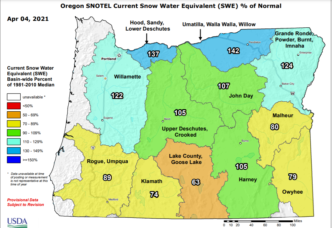
In the precipitation category it was a dry month with Salem receiving only 2.33″ (58%) of the normal monthly rainfall. For the mountains, the saving grace was that the storms we did have were quite chilly which meant our snowpack stayed above normal throughout the northern half of the state. Unfortunately, the southern half of the state is currently lagging behind as many of the storms this past month merely brushed the southern regions of the state leaving those regions even drier. This is reflected well on the map below.
There you have it. A pretty simple month. The cold front we had on Sunday the 28th was perhaps the most exciting event with widespread gusts of 30 to 35mph here in the valley along with a sharp drop in temperature that evening; otherwise it was a mostly quiet month.
I have a very special guest post today coming from a friend who lives all the way in New York City! She and her friend have written up a nice forecast over there highlighting what one can expect should you find yourself in that unique part of the world. 😉 Our local Salem forecast is tagged along at the bottom. ENJOY!!!!
Forecast for New York City
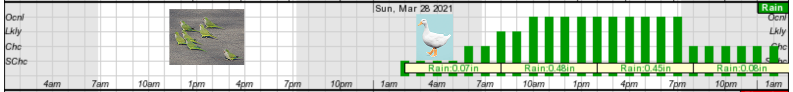
Saturday – a wonderful day, use best you can. Sunday…it’s for the ducks
Cold front will start rolling into NYC on Saturday around 4am and will calm the windy conditions seen on Friday. Clear skies with a temperature in the high fifties to low 60’s. Winds ranging from 12-25 MPH. Nice day that Saturday We recommend using it to get outside and catching a glimpse of the rare and exotic green parrots atop the Greenwood Cemetery Arch.
If you happen to forget your sunscreen on Saturday and end up getting a ring-tail lemur sunburn on your ankles, don’t fret, because Sunday’s weather will be keeping you inside. Early Sunday morning, starting at 2am, nice conditions will start to diminish, clouds will be low, winds will be light. Heavy rain will commence at 8am with winds hitting full tilt at 11am. Wind gusts will pick up to 40 MPH. As Sunday progresses, clouds will thicken like a split-pea soup (which apparently no establishment in NYC carries despite our repeated pleas) This will cause poor visibility and rain with the temperature in the low 50’s. Fog is not out of the question folks. Rainy conditions and visibility will improve during the evening, but wind will remain, so no skirts.
Monday the skies will be back to their old ways- a cool 55, partly cloudy, no winds. The perfect start to a week locked inside working. Looking ahead, Tuesday will be your last chance before rain picks up mid-week with the sun coming back to shine on all your beautiful, bountiful Easter eggs.
Salem Area Forecast
Looks like NYC has a similar weather forecast to us in that today is going to be a beautiful day with highs in mid 60s and lots of sunshine.
Sunday starts off nice; however, we also make a switch to weather fit only for ducks 😉 as things go downhill in the afternoon with a very potent cold front moving in. Winds will be strong at times gusting up to 35mph and rain will be quite heavy at times. If you have outdoor plans I would aim to have them done by 1 or 2PM on Sunday with rain moving in by 4PM at the latest.
Temps drop dramatically Sunday evening with this powerful cold front. Snow levels Monday morning will be down to 1000′. Lots of snow up in the Cascades. I’m thinking like 6 – 10 new inches with this storm. Very poor driving conditions up there Sunday night through Monday with gusty winds blowing that heavy snow around a bit. Back here in the valley we will be left with a few scattered showers on Monday before drying out for much of next week with highs returning to the 60s Tue – Thu or even next Friday.
Whether you are in the Big Apple or the Cherry City 😉 enjoy the nice sunny weather while it lasts and a special thanks to my friend and her roommate for writing up their gust post!
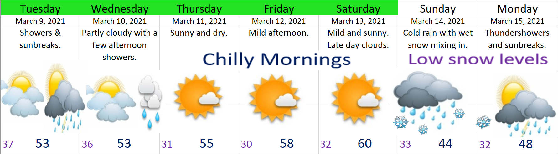
This week has gone pretty much as planned with showers today and continuing through tomorrow. Here’s a quick look at what you can expect now through Sunday.
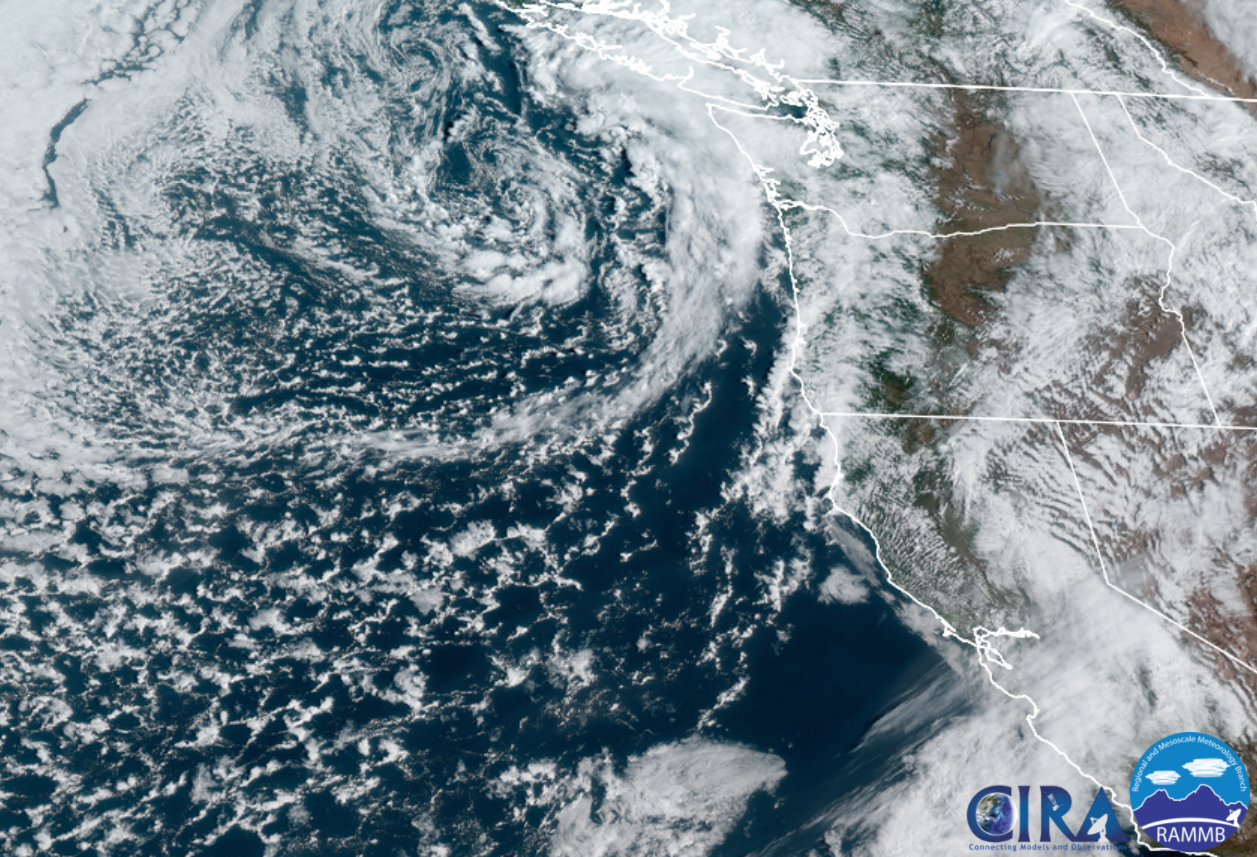
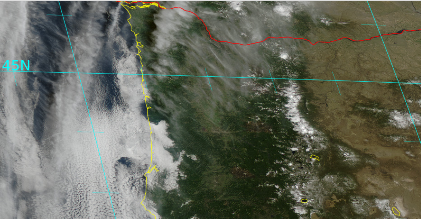
Today & Saturday will both be active days around here. Sunbreaks, lot of available moisture, and very cold air aloft (up in the atmosphere) will combine to give us a threat of a few thundershowers, downpours, and hail. Some of the showers could contain a lot of hail, so be careful if you are caught out on the road when one of these showers hits. This satellite pic from around 10:45AM shows a nice swirl of clouds and bands of heavy showers rotating towards Oregon. This will be our weather pattern through Saturday evening.
Snow levels are around 2000 – 2500′ with 5 to 10 inches of new snow falling in the Cascades through Saturday night. Expect snowy passes Monday, Wednesday and Thursday of Spring break.
Sunday will be the driest day this weekend with rain moving in sometime after roughly 3PM.
Spring Break
What everyone wants to know is which days are going to be nice and dry for outdoor activities, and which days are going to be wet. Fortunately, this guy right here has you covered! 😉
1.) Our mostly wet days will be Monday, Wednesday, and Thursday. These days will all have dry times mixed in between the showers, but overall expect these days to be wet.
2.) Now for the dry days! Tuesday, Friday, and next Saturday, & Sunday all look nice and dry!!! 🙂 🙂 So we should finally see a completely dry weekend around here!
There you have it. Stay safe, try to stay dry, and have fun out there!
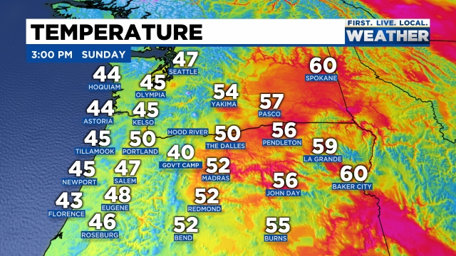
The forecast is still on track with a cold front moving through right now. Salem recorded a temp of 50° at 1PM and that will end up being our high for the day as colder air is already moving in from the northwest. You can see where temps stand as of 3PM with the coast being colder than central Oregon at the moment.
Snow levels drop down to 1000′ – maybe a little bit lower on the east side of the valley tonight as even colder air works its way down from the NW. Scenarios like this occasionally lead to “lower than expected” snow levels in east valley & foothill locations. Any lower than expected snowfall will be very short lived and minor, but don’t be shocked if you see a few slushy flakes mixed in tonight with the showers.
Monday should be a mostly dry day with just a few afternoon showers of rain, hail, and maybe some graupel. Graupel is really nothing more than a mixture of snow and ice pellets. Expect some of the showers to be rather heavy.
Nice dry and sunny weather looks like a lock for Tuesday and Wednesday before rain returns on Thursday through much of next weekend.
The Cascades
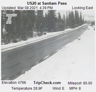
Passes turn snowy within the next hour and will stay fairly snowy through Monday morning with 3 to 6 inches of new snow. Santiam Pass has cooled 6 degrees within the last hour!
By Monday afternoon roads should be bare/wet as the increased energy from the March sun warms pavement up nicely this time of year.
It just doesn’t get better than this around here in March. Mostly sunny skies, highs this afternoon in the low 60s, and totally dry. I hope all of you are able to get out and enjoy the nice weather today!
Extended forecast
1.) Sunday and Monday we have a brief, but fairly major cool down on the way. Rain moves in Sunday afternoon transitioning into scattered showers on Monday. Snow levels will drop down to near 1000′ early Monday morning.
2.) A fair amount of sunbreaks on Monday with a scattered showers increasing during the afternoon hours.
3.) Tue & Wed: Dry and mostly sunny.
4.) Rain and showers move back into the area on Thursday and at this point look to continue through most of next weekend.
Checking out the radar this afternoon you can see a few scattered showers around with lots of dry breaks in between. Showers here and there, but the majority of the day has been dry. Expect basically the same exact thing both Tuesday and Wednesday.
Extended Forecast
Highlights
Thursday – Saturday:Totally Dry. Cool nights and mornings with lows dipping to freezing each night, but mild and sunny afternoons.
Sunday: A powerful and dynamic cold front moves in lowering snow levels close to the valley floor. I’ll keep an eye on this storm, but for now plan on valley rain with snow in the mountains above 1000′. This system will leave behind some very chilly showers on Monday with highs struggling to reach 50°.
The Cascades
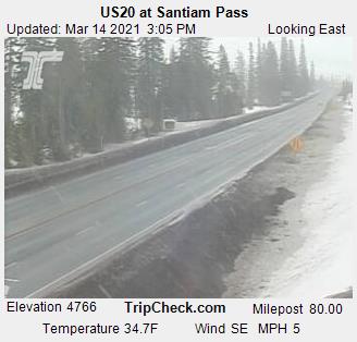
This time of year the roads generally stay clear of snow and ice during the daylight hours and this week is no exception. The road cam at the top of Santiam Pass shows this well. Temps below freezing with occasional snow falling; however, the road surfaces themselves are above freezing thanks to the increased energy output of the March sun.
I expect several more inches of new snow now through Wednesday night keeping a fresh layer of snow up there.
Sunny and mild Thursday – Saturday, but big time snowfall coming for Sunday and Monday with the cold storm system posed to move in.
Typical March weather around here with some nice sunny days this past week and highs that reached the upper 50s and even low 60s (61 degrees back on March 1st). But….. It’s March and it’s Oregon which means cooler and wetter weather is never far away and that really is how it goes around here.
This time of year I feel like the number one thing people ask me and want to know most is what days are going to be dry for playing sports, jogging, planning an outdoor social events (more common these days), hiking, or just working on outdoor projects around the yard, so I’ll do my very best to answer that. 😉
The rest of today through Tuesday: Showers at times every day; however, I don’t see any sign of an all day washout meaning you can expect a few sunbreaks or at least breaks and pauses in the showers each day. Not reliably dry days, but far from being complete losses either haha! The simulated radar image below for 10AM Sunday shows this well with scattered showers roaming around the northern Willamette Valley for that time.
Looking for dry weather then head east of the mountains. Much drier over there!
This pattern typically favors heavier showers during the afternoon hours, and that will go for every day now through Tuesday. Sunday in particular could see heavier showers though with hail and maybe a little bit of thunder or lightning for some of you.
Snow levels will be quite low during this period of time. I wouldn’t be surprised if people living up in the Coast Range or Cascade foothills above about 1000′ saw a dusting to an inch of snow one of these mornings. Here is the forecasted snowfall through Tuesday night showing snow in the Coast Range and the Cascades down to fairly low levels.
Monday stands the best chance of being mostly dry. Not 100% dry, but I’m thinking right here in the valley we should only see a couple of showers at most. Both the Coast Range and the Cascades will see a fair amount of showers still.
Wed – Fri: Nice and dry for the back half of our work week with highs returning to the upper 50s- maybe even 60 again. If you are wanting completely dry weather then these are the days for you.
Looking further ahead, another cool system drops down (unfortunately) just in time for next weekend….