There were 3 major highlights from the month.
Number 1.) The sizzling hot start to the month. Salem set a new record for June 1st with a high of 97°! The heat didn’t last long before we cooled off quite a bit. Then the rain came…
Number 2.) After such a dry spring we finally saw a good soaking with 1 to 2 inches of rain falling between June 11th – 15th. Our wettest stretch of days since the February ice storm.
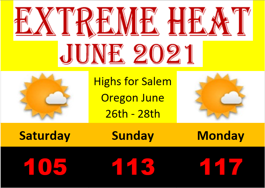
Number 3.) June 2021 hands down will be known for the insanely hot heatwave near the end of the month which brought record shattering high temperatures three days in a row.
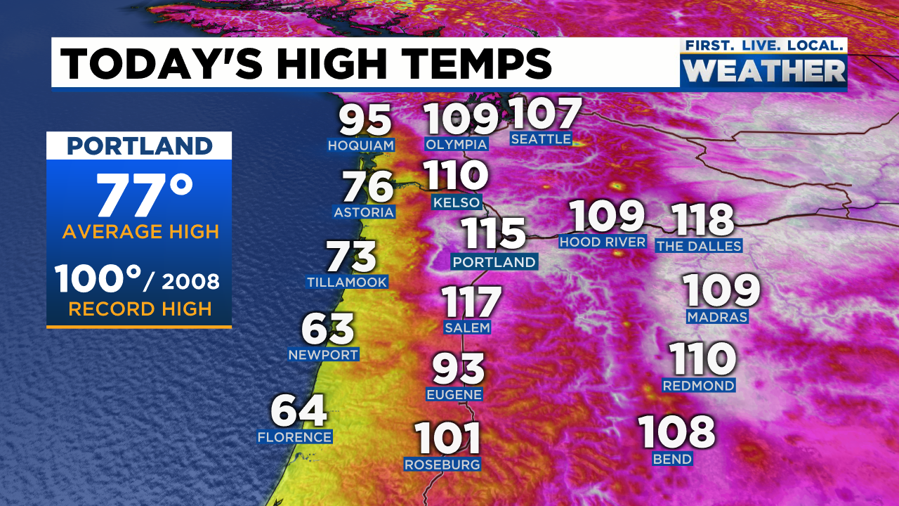
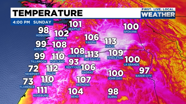
Those high temps were 27, 35, and an incredible 39° above our usual highs for those three days!! Truly remarkable. Here were the high temps across the entire region from Monday (June 28th).
You can see the sharp cutoff in temps out along the coast. Of course this was the day we had that 40 to 45 degree drop in temperature in a matter of hours as the cool ocean air finally flooded the valley ending our unprecedented heatwave.
There are three things which really made this heatwave historic. The first is (of course) the insanely hot temps. Prior to this event Salem had never in recorded history been above 108°. We blew through the record on Sunday with a high of 113 and then we blew through that new record the very next day with a high of 117!!
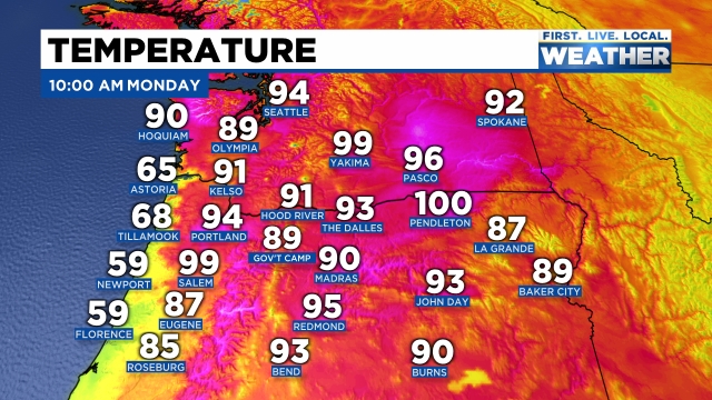
The warm nights were also a major aspect of this heatwave. Salem’s low temp Monday morning was 76° and there were parts of the Portland metro that never fell below 80° that night. YIKES!!! The warm starts to the days allowed us to warm up quickly which leads me to the third and final aspect of this heatwave and that was the duration of the heat.
The length of time it was hot each day added to the oppressiveness of the heat. Temps topped 90 degrees by 8AM on Monday! I’ve never seen that here before ever… Typically on a really hot day we reach 100 degrees right around 3:30 or 4PM and will stay there for just a couple of hours at most. This time though we experienced 100 degree weather for much longer all three days. For example, on Sunday many valley locations were above 100 degrees for 7 to 8 hours.
June 2021 Summary
Overall we ended the month an astonishing 6.67° above normal!!! An incredibly hot month with 10 days above 90 and of course our three back to back to back 100 plus degree days. We just lived through one of the hottest months on record! I imagine you all (like myself) are tired of these “once in a lifetime” weather events. In less than a year we have had a historic fire and smoke disaster, a historic ice storm – which left many people without power for days and even weeks, a historically dry spring, and now a historic heatwave. Leaves us wondering what the next “historic” weather event here will be as we seem to be on a roll unfortunately….
What’s funny and odd is how June 2021 ended up being a wetter than normal month. Yes! I know it may not seem like that could be possible, but if you recall we had 5 very wet days right in a row earlier in June putting us at 1.72″ (138% of normal for the month). Goes to show how statistics can be misleading. Everyone will remember this month, and rightfully so, for the intense and historic heat, but few will recall that for the first time since February we had an above/wetter than normal month.
Forecast
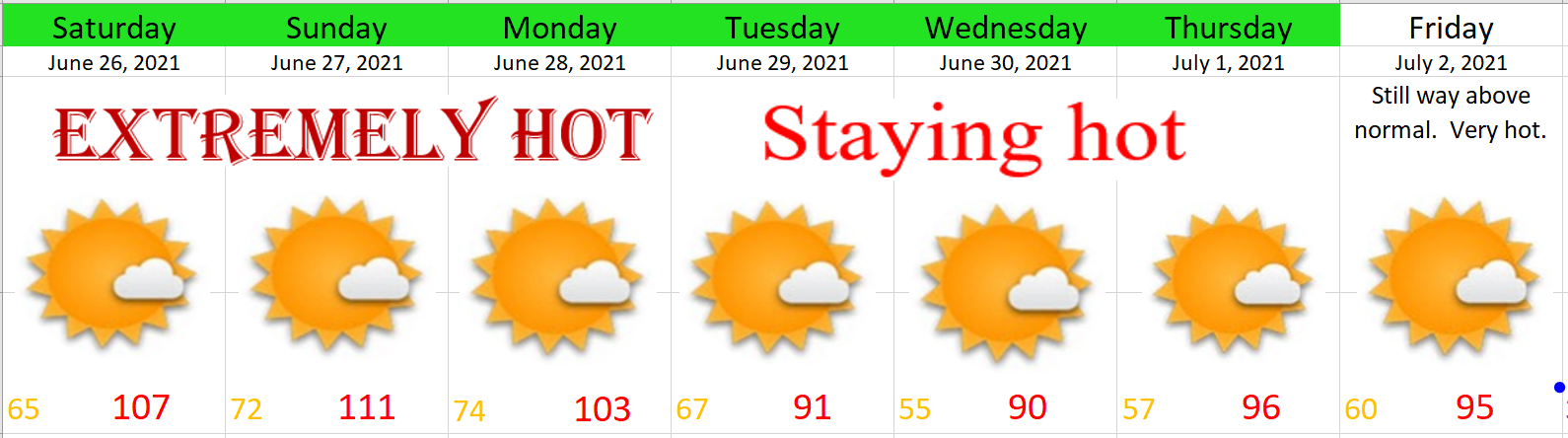
Tuesday will be hot with highs in the low 90s.
Wed & Thu will be the nicest and coolest days of the week with AM clouds both days and highs only around 80 or 81°.
Fri & Sat will be hot again as we climb back into the mid 90s!
Next week should feature more typical summer weather with lots of 80s. Still no sign of any rainfall.
Stay cool and stay safe out there!