Thanksgiving week

Thanksgiving is approaching and I hope you all have had a really nice weekend!

The theme over the next several days is grey. I still see no major rainstorms coming our way, but cloud cover remains rather persistent for the duration of the coming week with occasional shots of rain Tuesday through Saturday. Details below:

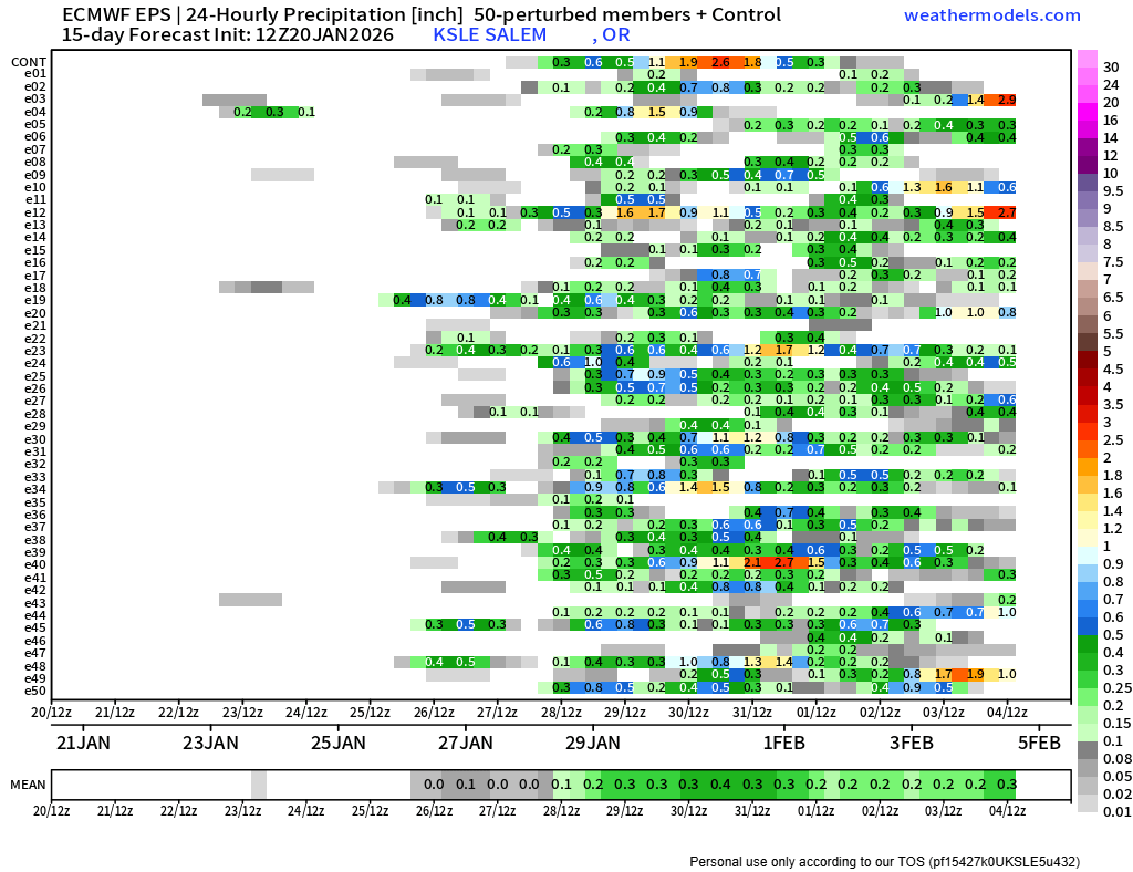
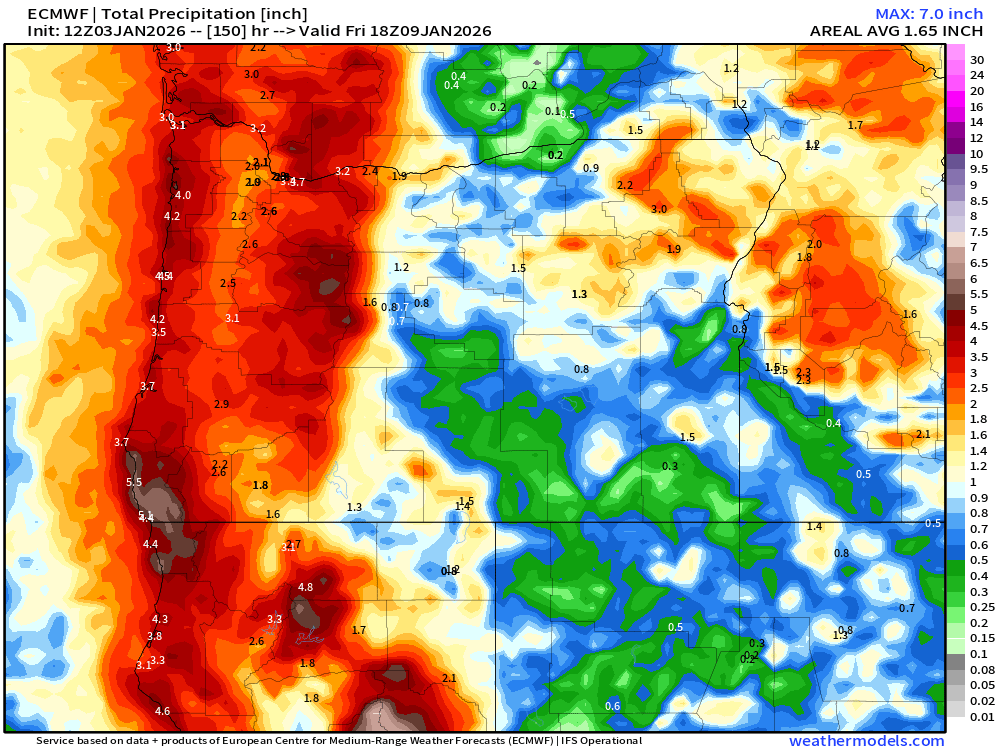
This next image illustrates why I think Salem will be wet Tuesday – Thursday of this week, but not a total washout. These are 234 hour rain totals ending early Thursday morning, and notice the steep increase as one heads north of Salem. This has Salem receiving 0.5″ (half an inch of rain), but well over an inch for Vancouver, Longview, and Kelso.

The final image shows 24 hour rain totals ending 10PM Friday night. You can see the shading is spotty and there are more greens and less blues and orange colors. This tells us we will see scattered showers and downpours Friday, but once again, I see no huge soakings for the Salem area.

I have slightly lower confidence in the forecast for the weekend, but I can tell you it will be cooler. Currently, I’m going for scattered showers Saturday, and then dry Sunday. By Monday morning (December 1st) I expect low temperatures will dip into the upper 20s for the first time this winter. Despite the cool weather, Monday should be mostly sunny and dry with highs in the lower 40s.

The Cascades

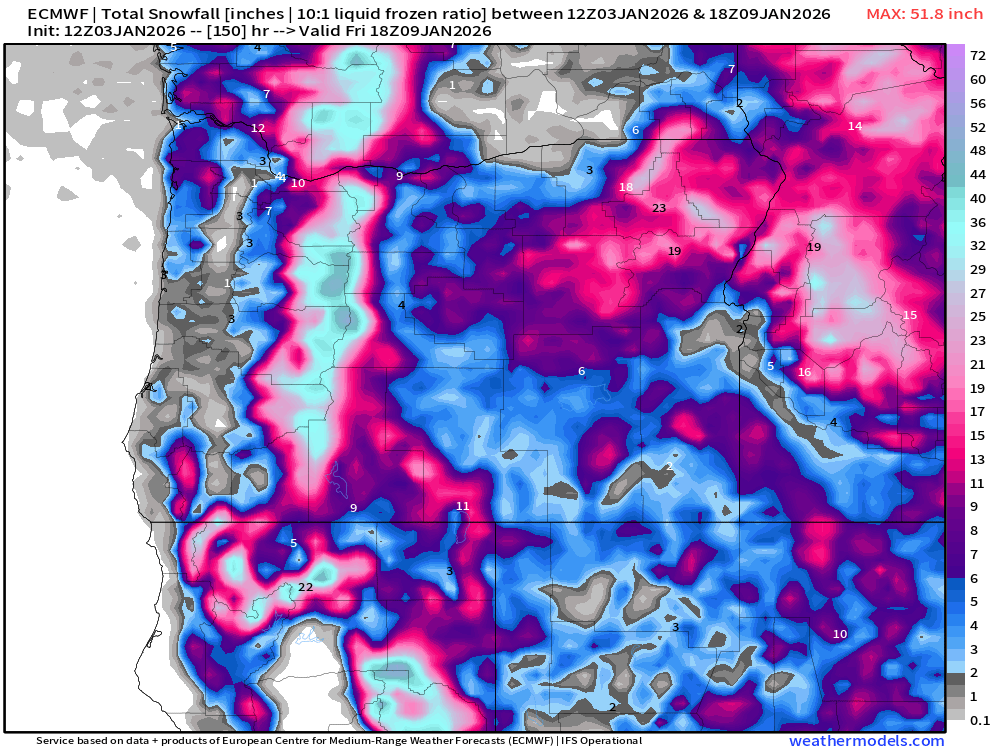
Other than some brief snowfall Friday, there should be no travel concerns for the Cascades this week. Good for travel, but not so good if you’re waiting to hit the slopes. Still very early in the season and remember, warm Novembers don’t necessarily lead to warm winters. Take a look at this post here for some evidence regarding the topic of Warm Novembers.

For now though, no big mountain snowfalls this week.

Have a great and safe week!

Looking towards Thanksgiving

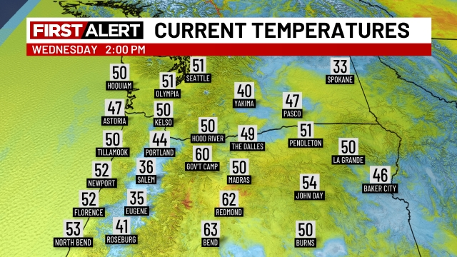
Things have been real mellow around here, and up until the past couple of days, it’s been quite mild too. Salem achieved a record high of 65° this past Saturday. The only thing that has really changed from this week compared to the previous week are the cooler temperatures. We hit the 60 degree mark eight days this month, but since that record high on the 15th, we have been in a cooling trend. Salem finally got down to 32° this morning for the first time this fall, and we never broke out of the 40s. Inversion season is definitely here!

The main message is that there are still no big storms on our horizon. No flooding scenarios, strong winds, chances for snow etc. Just more of the same: a little rain at times, some fog, and a few sunbreaks. The riveting details are below:

Tonight: Light rain switching over to scattered showers overnight. Chilly with temps in the mid to low 40s. Brrrrr!

THU: A few showers early. Dry afternoon and evening. High of 54°.

FRI & SAT: Dry. Fog seems very likely both days with a few sunbreaks possible during the afternoons. Highs in the upper 40s.

SUN & MON: Some rain both days, but nothing big or major that would cause significant issues for our day to day lives.

Looking ahead to the days leading up to Thanksgiving, and Thanksgiving itself, I continue to see no big storms. Maybe some mountain snow to deal with, but will have more updates again as we get closer to the holiday. The main message is that this rather calm weather pattern appears to continue for another week.

Warm Novembers

We have had a very warm November so far running almost 4 degrees above normal! Check out this map showing temperature departures from average so far this November.

Very warm in the west, and cooler along the east coast. Well I’m here to tell you that warm Novembers do not correlate to warm winters. In fact, maybe quite the opposite. Below I’ve charted temperature departure maps from four different years. All four of these years had similar La Nina conditions to what we have now, and all four of these years had very mild November temperatures – also very similar to what we have seen so far this November.

Looks similar right? Very warm out west and cooler along the east coast. Well, what happened after each of those warm Novembers? This next chart shows temperature departures for December through February from all four of those same years.

As you can see, the rest of those winters actually ended up on the cooler side. In some cases significant cooldowns occurred which lead to valley snowfall. How many of you remember December 2008 when it snowed several times in the weeks leading up to Christmas? Or December 2016 when it snowed several inches leading to an early Christmas break. Point is, a warm November does not equal a warm winter. If you could only see some of the comments in the weather forums I’m in then you would be laughing yourself to sleep. People claiming winter is over, others saying things like it’s difficult to imagine even the ski resorts getting enough snow to open this winter, and other super ridiculous nonsense.

We could end up with a dry and mild winter (has happened before, and it will happen again), but I’m not real worried considering it’s only the 19th of November, and again, the data I just shared indicates that warm Novembers do not necessarily lead to warm winters. Let’s see what happens…

Enjoy the rest of your evening and stay safe out there!

Weak sauce storms

As predicted, the “storms” the past couple of days have been extremely weak. Plenty of clouds, but only 0.19″ of rainfall this entire week with a few sunbreaks – just not enough clearing to really see the aurora borealis earlier this week. :/

It has been very mild lately. We are running 4 degrees above average for the month so far! So, what’s ahead? Well, the short answer is not much. Just a cooler version of what we have been seeing:

  1. No big storms through Friday.
  2. No strong winds or heavy rains through Friday.
  3. No big dumps of snow for the Cascades through Friday.

Looking beyond next Friday, I see the potential for cooler weather, maybe a chance for some bigger rain producers, and a higher chance for mountain snow. More details to come as time goes on, but it does appear our very mild November weather will be ending.

SUNDAY: Lots of clouds with scattered showers. High of 54°.

MON – WED: A few light showers Monday, and then dry. Similar to what we have been seeing only cooler: lots of clouds and a few sunbreaks here and there. Lows 35 to 40°, and highs in the mid 50s.

THU: The “strongest” storm of the week will affect us Thursday bringing steadier rain, breezy winds (nothing big though), plus a few inches of mountain snow. Morning low of 44° and an afternoon high of 54°.

Have a wonderful rest of your weekend and as always, stay safe!

Wet weather

We basically have three separate storms rolling through our region, but these storms are very small, and the energy with them is sort of splitting. What does that mean for us? Well, I thought about writing a whole paragraph trying to explain it, but let’s use some visuals instead. 🙂

This first image shows what a healthy consolidated jet stream looks like. This is from last week when we experienced strong gusty winds and heavy showers.

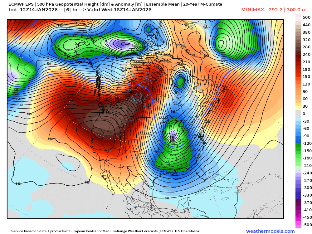
Notice the nicely packed lines butting up right into Oregon (indicated with the arrow). This consolidated jet stream directs most of the energy in the atmosphere into the same spot allowing stronger storms to develop. Think of this stronger and more consolidated jet stream as like being a train directing all of its force into one location. Now, take a look at the forecasted pattern for this Thursday.

What a mess! There are three separate pieces of energy hitting the west coast. This splits up the energy resulting in several weaker storm systems versus one large consolidated storm. Think of this setup as producing a bunch of spinning tops. Compared to a train, there is very little weight or force behind these spinning tops making it tough to forecast the details of where showers will hit, when they will occur, and how much rainfall will fall at any given location.

Forecast

Expect showers at times Thursday through Saturday with sunbreaks mixed in between. Best chance for dry weather during these three days will be on Saturday. By Sunday, the jet stream will sort of have its act together and should deliver a slightly stronger cold front to the region.

I see no strong winds, prolonged heavy rain events, arctic blasts, snow, or ice storms on the horizon for us. The next 7 days look pretty calm – just a little wet at times. Maybe a stronger storm next Thursday, but plenty of time for those details later.

Enjoy the rest of your week!

Dry until Thursday

We had plenty of rain this past week. Salem picked up almost 3 inches of rain just in the first six days of the month, so a break in the rain feels deserved. What’s even better is we have already broken free of the morning fog and low clouds and we are in the midst of a nice sunny Saturday, in November! 🙂 Enjoy! Sunday looks great too, although the fog might last longer on Sunday, but still nice and dry.

MON: Still dry, but cloudier. I could see a few sprinkles or light showers falling in the northern Coast Range and Cascade Range, but the valley should stay dry. A much gloomier day though.

TUE: Morning fog returns and may be slow to burn away. Partly cloudy afternoon. High of 56°.

WED: Partly cloudy. Increasing clouds late in the day. High near 60°.

Lows during the next several days will range from 38 to 43°. Nothing out of the ordinary.

THU: Rain returns. High of 55°.

An easy forecast for the most part. The morning fog is really the only weather related issue that could influence our lives a little between now and Thursday.

Enjoy the beautiful weather!! 🙂

Wild Wednesday weather

Headlines

  • Steady rain lasts all night long adding up to around half an inch.
  • Winds turn gusty Wednesday – 30 to 40mph.
  • Thunderstorms with stronger gusty winds and very heavy downpours are likely through Wednesday night. An additional half inch or more of rain is possible from these heavy showers.

Details

Sometimes in my forecasts I casually reference weather events from past dates, but then I have to remind myself that most normal people don’t keep such detailed weather records as me lol… Well, this time I’m only asking you to remember back two Saturdays ago which was the day we experienced gusty winds, heavy downpours, a few power outages, and some lightning. I think this Wednesday will be very similar.

Where and exactly when the heaviest showers and thunderstorms hit is impossible to know, but once again I’m relying on this estimated radar image (valid for 2pm) to give us a general idea of what we are looking at. Take a look!

Bright orange and red colors indicate heavy rain, and this clearly shows a good chance for numerous heavy showers/storms across much of western Oregon Wednesday. Storms could cause winds to briefly gust higher than 40mph, dump very intense/heavy rainfall, and even put down some lightning strikes. Watch for ponding on local roadways as well due to clogged drains.

The Coast

Coastal locations even have a slight chance of a funnel cloud or, if it touches ground, a tornado. This is the time of year is when the coast can see some of these weak funnel clouds or tornados. Rare, but they do happen more often in fall here. I’ll bee keeping an eye out for reports from the coast. Of course, this storm is also lining up perfectly with our first round of King Tides for the winter season. This makes it easier for large waves to travel higher up the beaches. Storm watching is a TON of fun here. Just be careful out there! 🙂

The rest of the forecast

Thu: More rain much of the day.

Fri: A few leftover showers.

Sat & Sun: Completely dry.

Mon & Tue: Slight chance for a little rain, but no big storms.

Highs ranging from the mid to upper 50s.

Still no real threat for mountain snow at the pass level this week, so I’m not worried about that affecting your travel plans.

Okay, enjoy the rainy night, and stormy Wednesday!

October 2025

Good evening! We cover a lot in this post. Here’s a super short “table of contents” for you:

  1. October 2025 temperature and precipitation stats.
  2. Highlights from October.
  3. Our extended forecast.

October 2025

October 2025 brought to an end a string of 6 months with warmer than average temperatures. We ended pretty darn close to average, but officially 1.1 degrees below normal. This image shows how high temperatures panned out for the month.

A lot of slightly cooler than average days, but nothing super wild. This next graph shows the same data, but does a good job of showing just how close to normal many of those cool days were.

That graph does an excellent job at showing just how dramatically our temperatures drop in October. I like it!

Zooming out to see the big picture, we can see how this October was really warm across much of the country with the west coast and a small corner of the southeast being the exceptions.

This next image shows precipitation per day for Salem for the month of October. In the bottom right corner you will find the total for the month and percentage of normal. Remember you can always click on images for a larger view.

Highlights from the month

October 2025 goes down as a mostly uneventful month. Our coldest low occurred on the 30th with a temperature of 34°. The most interesting weather events took place on the 25th when we saw widespread wind gusts above 40mph (45 in Salem), lightning & thunder, and heavy rain showers. The coastline experienced high surf as well. Nearly a foot of snow fell at the ski resorts the following day.

Our forecast

Mon: Showers in the morning turning into a steady rain during the afternoon. A chilly high of only 53° with around a half an inch or rain. A great day for warm layers and a rain jacket!

Tue: Lots of mid/high level clouds with a few peaks of sunshine. Mainly dry. High of 57°.

Wed – Fri: Frequent periods of rain and breezy too. Wind gusts 30 – 40mph Wednesday and again late Thursday afternoon and evening. Over an inch of rain spread over the course of these three days. Potential for some heavier downpours and maybe another thunderstorm or two Wednesday afternoon.

Sat & Sun: We might finally have a dry weekend (both days)! I mean today was great, but the very first weekend in October is the last time we have seen a totally dry Saturday/Sunday combo. Highs in the upper 50s. Rain appears to make a return next Monday or Tuesday.

Have great first week of November!!