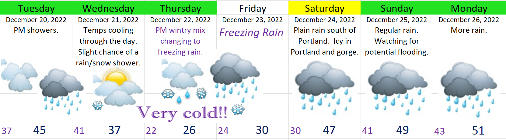
It’s been a very chilly month with Salem dropping to 22 this past Saturday morning making it the coldest temperature we have seen so far this winter and it’s going to get even colder. Tonight my confidence has dramatically increased for the mid that a fairly significant winter storm will impact the Willamette Valley Thursday – Saturday morning. Here’s the extended forecast and then details below.
Nothing exciting or special for Tuesday. Showers will increase later in the day, but that’s really it.
Wednesday morning an arctic airmass will begin to descend from the north bringing extremely cold weather. We will actually be right on the edge of this arctic airmass; however, its’ so cold that even a glancing blow will drop temperatures considerably. Slight chance of a snow shower this day, but odds favor the snow would not stick here in town.
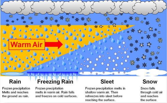
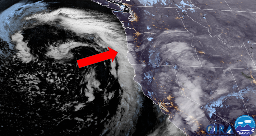
Plan on Thursday and Friday (maybe Saturday too) having awful weather and horrible travel conditions with widespread freezing rain here in Salem, and snow and ice in the Portland metro and gorge. The combination of extremely cold temperatures in the lower part of the atmosphere and the moist pacific storm poised to move in Thursday and Friday is going to cause a big wintry mess. Reference this graphic to see why freezing rain is possible even though temperatures will only be in the 20s. It’s not about how cold it is at the surface as much as what is going on further up in the atmosphere.
Thursday: Frigid arctic air continues to pour in all day long while a storm approaches from the west. At some point during the day a wintry mix of snow, sleet, and freezing rain will begin before quickly changing to just freezing rain. Here at the surface icy winds from the gorge will keep us in the 20s which means roads will also freeze up. Best guess would be precip starts during the afternoon hours.
Freezing rain will continue on and off through Friday night before Salem finally moderates above freezing early Saturday morning. This is the plan at least.
Things still up in the air
1.) How cold do we actually get before the storm hits? The colder it is the longer it will take to “warm up.”
2.) How much moisture falls while we are below freezing? Right now I’m going with somewhere around half an inch of freezing rain which while is far less than the Feb ’21 storm, but is still enough to bring down power lines and tree limbs. Closer to an inch is possible near Portland.
NEED TO KNOW POINTS
1.) Be prepared for power outages to last through Christmas day or beyond. I know this sucks, but half an inch of ice to an inch of ice is expected to accumulate between Albany and Portland with the gorge having even more. This storm will cause a lot of outages and work crews will only be able to work so fast.
2.) PLAN ON I-84 THROUGH THE GORGE CLOSING THESE DAYS. In fact plan on a number of road closures Thursday through Saturday morning all across our region.
3.) Honestly this is why it’s good to have supplies at home as stores will be running low on things for a few days. Just keep that in mind and be gentle and kind when out and about this week. I imagine stores will be busier than usual thanks to Christmas shoppers and people preparing for the storm.
4.) A warmup should take place on Saturday, but ugh….. This is honestly the part that has me the most worried. There is no real good push of onshore wind expected to help wipe out the cold air. What will happen is eventually the inversion should break and we warm up from above. *Refer to graphic above showing freezing rain setup. If the cold air is stubborn and slower to leave then we could have issues Saturday too, but for the moment I’m planning on Saturday being okay here in Salem.
Let’s not even worry about possible flooding after the ice storm, but keep it in the back of your mind that the week between Christmas and New Year’s Day is looking very stormy.
Phew!! I plan to update frequently this week. Stay tuned and stay safe and healthy out there!