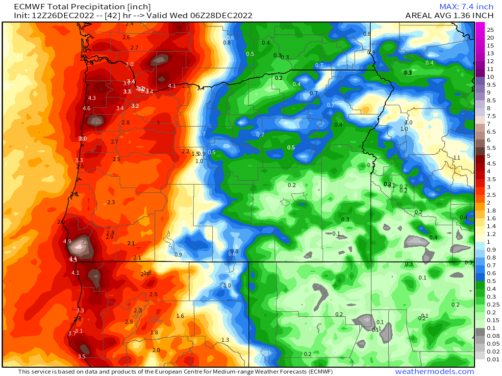
Thanksgiving week

This forecast should contain all the info you need to know regarding weather conditions for Thanksgiving and the Thanksgiving weekend. Let’s start with the basics. Here’s how the next 7 days are shaping up here in the mid valley.

Salem and the Willamette Valley

Wed – Sat: Dry. Clouds, areas of fog and sunbreaks at times. Maybe a few sprinkles Friday night/Saturday morning, but nothing big or of any concern.

Sun: Cool, rainy, and breezy.

No real issues over at the coast. Very similar weather to what we will see here in the valley with the minor exceptions being slightly more rain and at times stronger breezes, but again, nothing too crazy. There are no big storms on the horizon.

The Cascades and Central Oregon

Passes stay nice and dry through Saturday.

Sunday: The only day this week that will have some travel issues. Expect several inches of snow to accumulate in the passes throughout the day Sunday as a cold front sweeps through the region. Be prepared for snowy passes if your travels take you across the mountains Sunday.

Now a quick look at how the month has played out so far.

As of the 22nd, Salem has seen 12 days with temperatures at or below freezing. We are quite literally running polar opposite of the sizzling warm temps we experienced back in October. Currently for the month we are sitting 5.5° below normal. Brrrr! Check out how the entire country is looking as of the 21st. Very chilly/cold in the west – a stark contrast to October for sure!

As far as precip goes, we had a real wet start to the month with 5 inches falling in the first seven days, but since then we’ve been mostly dry with the rain today breaking a 9 day dry streak – not bad for mid November! The rainfall today and the rain expected Sunday through next week will help Salem end the month above normal for precipitation.

Happy holidays! Be safe, stay healthy, and enjoy this festive time of year!!

Stormy weather

Well it’s been several days since I had time for an update as it’s been a busy stretch with work. I was bummed out how last weekend’s forecast turned out, but that’s how it goes sometimes. On to our extremely busy forecast!

Tonight and Friday: Very windy and rainy. Around 1.5 to 2 inches of rain is forecast through early Saturday morning. This will lead to localized flooding especially along creeks and locations adjacent to clogged storm drains. In addition to the rain and possible flooding, winds could gust up to 45mph. I suspect we will see a number of power outages as well throughout the day.

Saturday: Scattered showers and sunbreaks including a chance for hail and brief but intense downpours similar to the ones we saw earlier this week.

Sunday: A chilly rain transitioning into showers. Highs in the low 40s. Brrrrrrrrrrr!!!!

Monday: Cold showers. A few sunbreaks at times.

Next week looks cold – especially for this time of year. No signs of any snow yet, but be sure to stay tuned for updates! Right now Tuesday and Wednesday are looking especially cold with lows in the upper 20s and highs in the low 40s, so prepare now for a solid freeze next week!

The Cascades

Our mountain passes and ski areas are going to get washed out with the wet and mild storm we have coming in now. Don’t let the “no snow” forecast trick you. Travel conditions through Friday night will be downright awful in the passes with heavy heavy rain and gusty winds. Nasty weather for sure.

Then the colder air moves in. Expect snowy passes Saturday through Monday with 12 to 20 inches falling above 2000 feet.

That’s all for now. Stay safe out there!

Weekend forecast

Okay, it’s been a week since we saw a big pattern change from warm & dry to cool & wet, and for the most part things have gone according to plan. The first 20 days of the month featured not one drop of rain, but now 7 of the last 8 days (including today) have seen measurable rainfall. The Cascades have also undergone change with several inches of snow blanketing the volcanic peaks. I really like these before and after pics of Mount Hood with the first picture taken on the 19th and the 2nd pic taken during the early morning hours on the 27th.

By the way, yesterday was just awesome (my opinion) with sunny skies, and comfortable temps. Anyway, here’s the extended forecast for Halloween and the week to follow:

Highlights

1.) Saturday will be mostly dry. It’s just probably going to stay cloudy for much of the day.

2.) Sunday looks great! Classic dry fall day. Fog is likely through the morning hours, but afternoon sunbreaks will follow with temps reaching 60 degrees or higher. 🙂

3.) Halloween starts off dry; however, rain moves in for the late afternoon and evening. It’s unlikely this will change, so plan for a wet evening.

Looking ahead, next weekend (Nov 4th and 5th) could be very wet/stormy, so if you’re hoping for dry weather I would take advantage of this weekend. Just a little heads up.

Have a wonderful and safe weekend!

Incoming

It’s awful that we are having to deal with fires and smoke in the middle of October, but here we are. Of course some of these fires were human caused, so they are not so “wild.” With that in mind, it is true that regardless of the cause, fires would not be burning out of control like this if our regular early fall rains had showed up on time.

I’ve been mentioning it for awhile now, and it’s finally almost here. The transition from warm, sunny, and dry weather to cool, stormy, and rainy weather will be quick and it’s coming this weekend! Before we dive into anymore details, take a look at how the entire country is doing in regards to temperature so far this month.

Map showing temperature departures for the month of October compared to average.

The pacific northwest is both metaphorically and literally on fire with the majority of locations running 8 to 10 degrees warmer than normal! Meanwhile the east coast has already started winter. Do you realize that parts of Florida dipped below freezing this morning? Back here in Salem we haven’t even cracked 40° yet…..

This next chart is one I enjoy using during the fall and winter months. Time moves from left to right with each horizontal line representing a possible outcome. In this case it’s showing how much rainfall is expected here in Salem. What really stands out is that after Thursday we are done with the days and days on end of reliably dry weather. The rainy season is definitely upon us meaning our prolonged summer is nearly over. There will be no gradual transition into wet season this year. It’s arriving late, but arriving in full force very soon.

Here’s the next 7 days

Highlights

Wed & Thu: Smoke will continue to plague our air quality both days as we continue to stay in a dry and warm pattern.

Fri: Dry with increasing clouds. Rain moves in late afternoon/early evening.

Sat & Sun: Showers and periods of rain with a few sunbreaks. Could see some hail and maybe a rumble of thunder too. Meanwhile the Cascades will actually see their first dumping of snow over the weekend with 4 to 8 inches falling by Sunday night. Sunday will be much drier with sunbreaks and just a few isolated showers around.

More storms roll in next week continuing the stormy weather pattern.

Lastly, it is going to be yet another La Niña winter meaning I expect our winter to overall trend wetter than normal with elevated chances for both flooding and valley snow. Not guarantees; however, La Niña winters favor rainier, snowier, and stormier weather than a typical winter. We will see what happens. Here’s a look at the current sea surface temperature anomalies. The classic La Niña signature of cooler than normal waters off the coast of South America really stand out on here.

Late season fire and heat

It’s super late in the year to be seeing 90s, and yet here we are. Salem set a record high temp today 27 degrees above normal at a “scorching” 92°. The stretch of heat we are having is historic, and it’s tragic too in that wildfires continue to burn across the state of Oregon. Here’s a temperature map from 4PM showing the extremely hot temps around the region. Keep in mind it’s October 15th…

The forecast for the coming week is for more sun, more warm temps, more smoke in the air at times, and of course, still no rain. The “coolest” day this coming week will be Monday with highs reaching about 70 which is still warmer than normal by several degrees. We warm back up into the 80s Wed and Thu.

Now if you read my previous post, then you probably remember how optimistic I was that a switch to wetter and cooler weather was coming, and indeed it is still on schedule to arrive right around the 22nd. It can’t come soon enough though as I feel many of us are tired of the warm smoky air. I will happily update you all later this coming week with more details regarding our big and overdue change in the weather, but in the meantime I suppose we should all try our best to enjoy this very warm weather.

Our Extremely warm fall

I admit I’m stating the obvious when I tell you that our fall season so far has been both extremely warm and dry; however, the part which sticks out the most is the warmth. We have been in record setting territory, but does this mean we might have a warm and mild fall/winter season too, or is there any correlation at all? We’ll take a look in this post. If you’re hoping for a forecast I can tell you that basically it’s looking dry for at least the next 7 or 8 days, so nothing new or exciting, and sadly nothing to really help put out the fires which continue to burn across the PNW.

This past September ended up 3 degrees above normal with only .29″ of rain (just 20% of normal) making for an extremely dry month! In addition to that, September 2022 also recorded seventeen 80+ degree days making the past month feel like an extension of summer. Look at how warm the western half of the country was during September.

Much of the western U.S. was 3 to 5° for the month.

October has also started out extremely warm with 6 out of the first 10 days reaching the 80 degree mark vaulting Salem to 6 degrees above normal for the month! Here’s the temperature anomaly map for the month so far:

The entire state of Oregon and Washington are currently running 6 to 10 degrees warmer than normal for October.

What’s really bizarre though is we have seen years in the past with extremely warm and dry Septembers and even Octobers during La Nina conditions only to flip to stormy weather. Currently we are experiencing (for a third year in a row) La Nina conditions – something to keep in mind.

Let’s look at September 1974. It was a La Nina year and a mere .28″ of rainfall for the entire month which is almost identical to the amount we saw this September. September 1974 was also extremely warm with a whopping 21 days above 80 and 11 days at/above 90°!

So what happened in 1974 after such a warm and dry early fall? Well over 14 inches of rain fell in November and December alone coupled with tons of mountain snow. Let’s look at a few more examples.

Exactly one year later in 1975 (La Nina year), Salem recorded its driest September on record. Not a single drop of rain fell the entire month. It was also very warm with eighteen 80+ degree days. The second half of October through December brought over 16 inches of rain though, and even some pre Christmas snowfall.

How about one more example? September 1998 was very dry as well with only 0.68″ of precip and plenty of mild days to boot. The following November and December dumped 20 inches of rain here in Salem resulting in widespread flooding. Worth noting that this was also a La Nina winter…

Bottom line is a warm and dry first half of fall can easily switch to a very wet, cool, and stormy second half. To be honest, that’s exactly what I expect will happen this year within the next 2 weeks. Watch for updates as the rainy season draws near and enjoy the warm and dry weather while it lasts, because it won’t last for much longer. Winter and the rainy season is coming, it’s just taking it’s sweet sweet time to arrive, but remember this post and know that you’ve been warned. It is coming…. It won’t be long before everything is all soggy, puddles everywhere, the rivers flowing high, and we will start wishing for sun again.

Out of the blue

After a loooong long stretch of not posting, I’m back with a helpful update for you all.

I’ve seen a number of various forecasts for the coming days all disagreeing on whether or not it is going to rain here the next several days, and I figured it was time to leap back into action. I have all the details below.

Basically we are on the northern edge of very moist storm which is aimed for California. This is GREAT news for bringing the wildfires under control plus a good soaking rain like this should help prevent any new late season fires from starting. This satellite image from around 1:30PM does a good job of showing the storm’s location as it prepares to hit California.

Highlights

A round of showers and maybe even some thunderstorms roll into our region later this evening through the early morning hours of Sunday from the south/southeast – a fairly unusual pattern for western Oregon.

Monday: Mild and dry with highs in the low 80s.

Tuesday: Mainly dry here in Salem with the exception being locations just south of us roughly from Albany and Corvallis southward. Showers are much more likely down there.

Wed & Thu: Showers both days with highs in the low 70s.

Fri: Back to regular dry and mostly sunny early fall weather! 🙂

The rain coming up from the south should also help significantly with Oregon’s major fires too including the Cedar Creek fire. I fully expect much better news on the fire front come mid week.

Take care and stay tuned for more updates! 😉