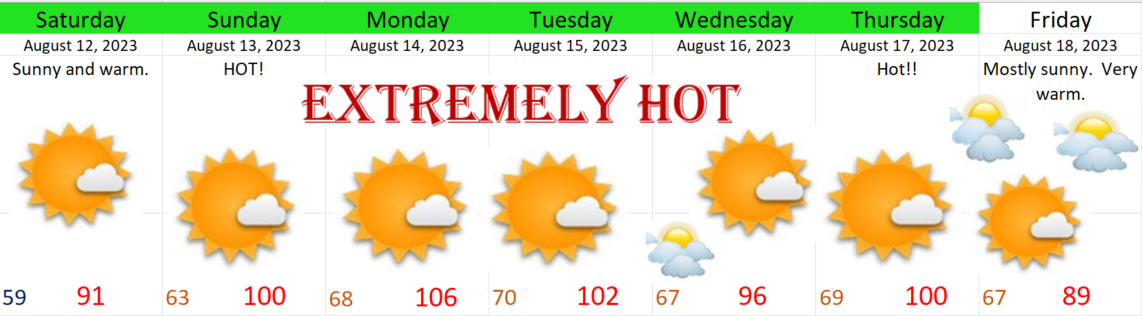
Mid April update

I’ve been taking a little break from providing you all with wonderful forecasts. Life has been busy with work, taxes, and everything that else that’s been popping up lately. Of course you absolutely do not need a forecaster to inform you this spring has been both very chilly and wet. If you’re looking for a forecast then skip to the “Look Ahead” section; otherwise, here’s a quick recap of spring so far.

Salem ended the month of March 4.5° below average making it one of the coldest Marches since the mid 1980s! Precip was a little above normal with just over 5 inches of rain. Fast forward to April, and we are currently sitting 3.8° below normal, and have 3.63″ of rain so far which is drastically above where we should be for precipitation at this point in the month. In case you need any more evidence our spring has been cool and wet, check out the snow water equivalent map for Oregon. This map essentially measures how much water is stored in the snowpack compared to average for this time of year.

Look Ahead

Rest of today: Dry through the evening.

Sunday: It’s back to “normal” with rain and breezy winds at times with gusts 20 to 30mph.

Mon – Thu: This will be a pretty chilly and wet stretch of days with periods of rain, occasional downpours, more hail likely, maybe a thundershower, and gusty winds at times. The Cascades will pick up another 2 to 3 feet of new snow this week adding to the snowpack up there. The trickiest days to travel the Cascade passes will probably be Mon – Wed.

That’s it for now. Still waiting to hit 70 degrees though.

Can’t catch a break

I thought my forecasts have been turning out so well lately, and then yesterday happened. “Upper 50s” turned into a high of 47°. Brrrrrrrrrr! Sure, it was dry outside – small victory, but we couldn’t shake the clouds which kept the cold air from the night before trapped. Here are Monday’s high temps from the region.

I mean check out Seattle almost topping 60°. I’m thrilled to death for them lol, but what a huge bummer for us. Now I’m having to downgrade Wed – Fri too. These 3 days were suppose to be “nice and dry with highs in the 60s,” I looked back and that’s actually what I said, but sadly that is no longer the case.

Both Wednesday and Thursday should still see a fair amount of sunbreaks with Wednesday being the sunniest day, but temps will probably top out just shy of 60°. The other bad news is that there is a slight chance of a PM shower both days. Most of us should stay dry each day, but our totally dry days are now threatened by a few isolated showers. With that said, Wednesday and Thursday are your best bet for dry weather for the foreseeable future, and the majority of the region will in fact be pretty dry, so make the most of these two days.

Friday’s forecast really went down the drain. Showers and light rain will increase through the day keeping temps in the upper 40s.

If you were hoping for dry weather than you should have stopped reading a long time ago haha. Saturday and Sunday look very similar to what we just saw this past weekend with breezy winds, downpours, hail showers and heavy snow in the mountains. Travel through the Cascades Friday evening through the first half of next week looks to be very snowy. Tons of new snow on the way for the mountains beginning on Friday.

So, enjoy the “mostly dry days” and the “almost 60 degree highs,” on Wednesday and Thursday lol, and find time to relax, smile, and remind yourself that warmer weather will eventually return. Look for another update later in the week with more details regarding our return to cold and stormy weather.

Snow and wild weather

Well that was fun! Many of us have seen hail, graupel, rain, and snow today with some short lived sunbreaks in between. I hope you enjoyed the exciting weather because we basically do it all over again Saturday with some minor differences. Here’s the plan:

Saturday: Anyone could wake up to a coating of wet snow. Chances for morning snow is slightly higher than what we saw this morning which means more neighborhoods could wake up to snow this go around. Snow will melt quickly however, so don’t panic or cancel plans if you wake up to a winter wonderland, because it won’t last long at all. During the day expect the same routine with sunbreaks, hail showers, and downpours.

Sunday: One final chance for early morning snow. The daytime hours will see more sunbreaks than what we saw today. Heavy downpours will also remain possible for all locations, but to a lesser extent meaning more dry times than wet.

Monday: Chilly frosty morning with afternoon sunshine pushing us into the upper 50s

Tuesday: Cloudy, wet, and chilly. This is actually a tough forecast as we will be right on the edge of a large storm; however, at this time I’m going with light rain much of the day based off of past experiences in this setup.

Wed – Fri: Looking nice and dry with highs in the 60s!!! 🙂

Cascade passes will remain very snowy overall through Sunday morning before things finally calm down up there. Lots and lots of new snow in our mountains lately!! 🙂 I see Hoodoo Ski Area has a 92″ base!!!

Take care and happy Friday!!

Stormy weather

I hope you all are having a nice day and have enjoyed the nicer weather we have had lately. For too long we were locked into a chilly pattern which brought multiple chances for snow to the mid valley. Those snow events made for some challenging forecasts, and while I enjoy the snow and I’m happy with how most of the forecasts turned out, I’m glad to see nicer weather and a much needed break. 🙂

Of course it’s springtime here in western Oregon which usually means the breaks don’t last long, and indeed, our beautiful weather will come to an end this afternoon.

FORECAST

Today: Sunny until 4 or 5PM at which time showers and thundershowers will roll in from the west putting an end to our sunny and mild weather. In this particular pattern, the east side of the Willamette Valley has the highest chance of seeing downpours and thundershowers this evening; however, anyone could get soaked. Very hit and miss with the showers today, and that’s just the nature of this type of pattern. Whether you get a downpour or not, the mild weather will end today.

Thursday through Sunday

Expect the same type of weather all 4 of these days. Heavy downpours, sunbreaks, and hail showers. I’m also thinking anyone could see snow in the air (not really sticking that much) during the nights and early morning hours as cold air returns with this storm stystem. Locations in the higher hills outside of town have a better chance of waking up to a dusting of wet snow.

What seems more likely is significant hail accumulations. With an unstable airmass and very cold air aloft (up in the atmosphere), I’m thinking some of these downpours and thundershowers will drop quite a bit of small hail enough to briefly cover roadways which could lead to treacherous travel conditions.

This map shows total snowfall in inches through Sunday evening. Both the Coast Range and the Cascades will see plenty of snow. The Cascades in particular should pick up some 2 to 3 feet of new snow with more on the highest peaks. This map also shows Salem getting about a trace of snow which in reality means nothing more than snowflakes in the air.

Again, there is a larger threat that hail could cover the streets and surfaces this week than snow.

Lows each morning will be 33 to 36 degrees and highs will likely stay in the upper 40s, and coupled with the hail and downpours, it should be a wild few days.

I’ll have an updated forecast later this week with any updates as well as a look at our spring break.

Take care!! 🙂

Late night special

It’s late, but for those who are still up I have a quick update for you all. Just got home from some very enjoyable family time – don’t miss out on the things that matter 🙂 and it’s looking like we will have yet another brush with winter Friday morning. Right now as I write this, very cold air up in the atmosphere is approaching the coastline of Oregon and will be over us by 3 or 4AM. Heavy showers will accompany this cold air and the heavy precip will drag that cold air and consequently the snow level down to the valley floor in some locations. We have seen this time and time again over the past 3 or 4 weeks now. Each time someone in the Willamette Valley scores some heavy wet snow while other areas got nothing.

Highlights

I expect lots of snow in the air Friday morning with accumulating snow in locations which see heavier snow showers. Anyone could see a slushy 1 to 3 inches of snow with more the higher up in elevation you go. Roads will be just fine by 10 or 11AM at the very latest even for areas which receive snowfall as we will transition right back into our regular routine of sunbreaks and showers. I think this simulated radar image for 6AM shows my thoughts the best with hit and miss areas of heavy wet snow and areas in between that see very little at all.

Tons of snow for the Cascades and of course the Coast Range too.

Saturday will feature more dry time than wet with lots of sunbreaks and only a few showers.

Expect more rain on Sunday.

Okay, take care!

Another chilly and busy week

We are having a hard time shaking the cold and wintry weather this year. I mean, it seems to be like that a lot of years, but this year we are having an especially difficult time. Our average high this time of year is 55°. We won’t even be close. In fact, we will likely barely scrape 50 degrees this week.

We are in a cold and showery pattern, and last night was a perfect example of what could happen any night this week. Late Saturday evening a band of showers moved over Newport and Lincoln City dropping the snow down to sea level in both locations. Here’s a traffic cam pic from around 8:30PM showing fairly heavy snow falling over Highway 101.

Much of the city ended up getting a nice coating of snow. Many residents down in the Eugene area also woke up to snow this morning. We remain locked in this same chilly and stormy pattern for the rest of today, Monday, Tuesday, and Wednesday. Keep in mind today will almost certainly be the cloudiest day of the next 4 days.

HIGHLIGHTS

Each day will feature sunbreaks (perhaps quite a few), but each day will also feature downpours of rain, graupel, and hail. Thunder is possible as well. The tricky part is that should an organized group of heavier showers move through during the evening/overnight hours, anyone could see an inch or two of snow. Lows each morning will be around 30 to 33 degrees, and highs should reach the upper 40s.

This chilly and showery pattern is depicted well on these simulated radar images. Basically this model (which I like to use often) guesses exactly where precipitation will occur, how heavy it will be, and what type of precipitation will actually be falling. The greens, yellows are light to moderate rain, and the oranges and reds indicate very heavy rain. Blue represents snow with the darker blues standing for heavy snow.

This first image is for 6AM Monday morning.

This shows a big snow shower moving directly over Salem just prior to the morning commute. Of course if that band of snow shifts slightly to the north or south then we end up with nothing. Very similar to last week in that where the bands of snow setup will determine who does and who doesn’t get accumulating snowfall during the overnight hours.

This next image is for 6PM Monday evening.

This gives a good indication of what our afternoons each day this week will look like. Notice the strong line of convection (heavy showers) stretching from Portland down to around Eugene. I imagine hail, graupel, and heavy rain occurring with this line of storms all thanks to the very cold and unstable air up in the atmosphere fueled by sunbreaks earlier in the day. The rule of thumb in this pattern is: the more sunbreaks you get with a chilly and moist unstable atmosphere in place, the more likely you are to “pay for it” later with heavy showers/downpours or even a thunderstorm.

Hopefully you’re catching my drift here. Lots of showers and sunbreaks with heavier showers increasingly likely during the afternoons and early evenings. Showers will remain possible at all times of the day and night and that’s where are chance for snow comes in.

Any snow that falls would not add up to more than an inch or two at the very most, and it would melt very quickly as the days are growing longer, the sun sits higher in the sky, and we have no arctic air to keep us really cold during the daytime hours.

Looking further ahead

Thursday through next weekend could end up being quite stormy with some potentially strong systems effecting our region. The main impacts at this time look to be heavy rain in the valley, and lots of mountain snow. Too early to know how low snow levels will be and how much rain we get etc. Just keep in mind that some bigger storms could be aimed at us the second half of this week.

The Cascades

The mountains are doing great with all this chilly and wet weather. Tons of snow up in the Cascades right now. I believe Hoodoo Ski Area is a little over 81 inches at their base. According to this chart it appears the snowpack in every region in Oregon is doing really well with more on the way and again, no sign of warm weather yet.

Expect snow showers over both the Cascades and Coast Range this week with sunbreaks at times. Should be great skiing weather! I’ll keep an eye on the forecast for the end of the week as there could be a lot going on then. In the meantime enjoy this cold showery pattern and stay safe out there! 🙂

Snowy landscape

Lots of beautiful pics from around town of the snow this morning. Very wintry out there with heavy snow falling early this morning. Here are a few snowy pics from earlier today.

Do you realize our average high temps for this time of year are in the mid 50s? We are running way below average. Here are regional temps as of noon.

Forecast

The rest of today and tonight: Snow showers will pick up this afternoon and early evening. Anyone could see another coating of snow on all surfaces at all elevations (even the valley floor) with this final band of enhanced snow showers. Locations on the east side of the valley like Stayton, Sublimity, Turner etc. stand the highest chance of seeing a fresh dusting of snow before we dry out. Lows tonight are headed for the lower 20s which means any location with snow or slush on the roads still will freeze solid.

Wednesday: We start off frozen and cold, icy in places, but dry. Highs in the mid 40s.

Thursday: A cold rain with lots of mountain snow. 4 to 8 inches of snow in the Cascades above 1500′. 2 to 5 inches of new snow in the Coast Range. Highs in Salem in the mid 40s.

Friday: A chilly morning with lows right around freezing. At this time not anticipating big problems this day, but I’ll watch it closely. A batch of showers this morning could spell issues again.

Saturday: This looks to be our next real shot at widespread snowfall. This is several days away still; however, it has potential to deliver, so I’m watching it closely.

Okay stay safe out there!