Hopefully you all have had chances to enjoy the great outdoors and the wonderful early October sunshine! We have a much wetter week ahead, but there will still be a few dry times here and there. Details below!
Highlights
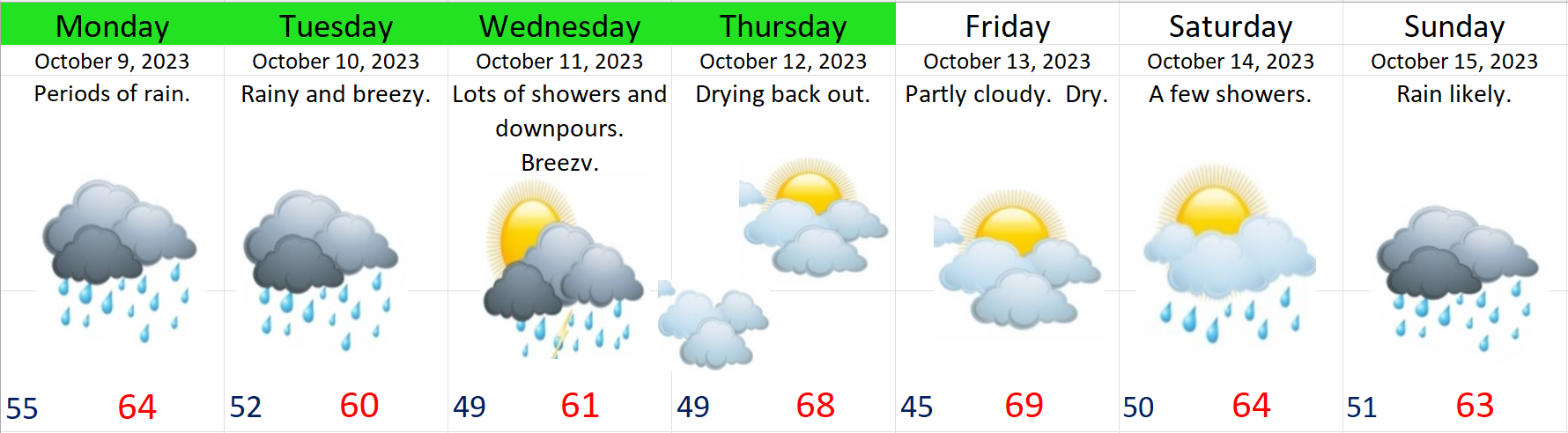
Monday: Periods of rain.
Tuesday: More rain, and breezy.
Wednesday: Stormy with heavy downpours and gusty winds at times.
Thu & Fri: Both these days should be dry starting out with morning clouds and fog before transitioning to sunbreaks during the afternoon hours. Highs should warm up close to 70°.
Saturday: A weak system will bring a couple light showers. Expect sunbreaks to mix in between showers. Not washout by any means with more dry times than wet.
Sunday: The rainy weather returns with a stronger storm.
The Coast
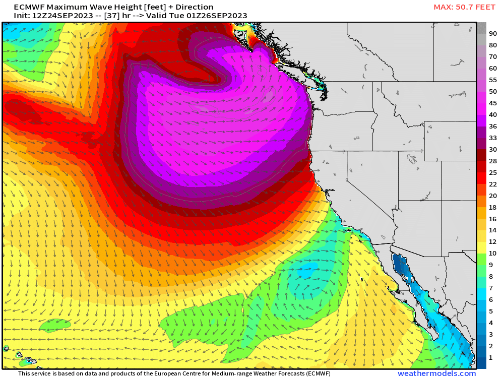
The coast will see increasingly large waves over the coming days. With maximum wave heights reaching 30 to 40 feet Tuesday night through Wednesday morning before slowly relaxing as we head towards Thursday.
The Cascades
It’s not quite that time of year yet, but some of the highest peaks will see a dusting of snow Tuesday night and early Wednesday morning. No big travel concerns though as passes will be rainy and breezy.
Okay, have a wonderful week and stay safe out there!!
Life has been much busier than usual, so tonight it’s a short and sweet update.
Monday: Wet and cool. Highs in the upper 50s. Lots of clouds.
Tuesday through Sunday: Dry. Tuesday should be the coolest day, the rest of the days should feature mostly sunny days, maybe some morning fog. Highs in the upper 70s to near 80 for Thursday, Friday, and Saturday! Some wonderful late season warmth!!!!!!
Rain looks to return the following week, so enjoy the sunny and dry weather (after Monday of course lol).
The forecast is very much on track; however, I do have a quick update on the storm moving in tonight. The mid Willamette Valley should see widespread wind gusts of 20 to 30mph tonight through the early morning hours on Wednesday. We get stronger winds every year in fall, so this won’t be a big deal; however, considering it is the first wind “event” of the season and trees are still full of leaves, I suppose we could see a few branches down and maybe a power outage or two. Downpours are also likely tonight as the storm moves through. Don’t be surprised if you hear the rain in the middle of the night.
Thu & Fri: A few showers, but not as intense as what we have seen lately, or what I expect us to see tonight and Wednesday.
Sat – Mon: AM fog, PM sun. Three very nice mostly sunny fall days. In a typical fall like fashion, lows will dip to the lower 40s at night, and highs should range from 65 to 70° depending on how long the fog sticks around.
Showers look to return either Tuesday or Wednesday of next week.
Hopefully you all are enjoying the fall weather. Have a great night!
Welcome to fall! We’ve had some really nice September weather the past couple of weeks, but now we are shifting gears into a much wetter and stormier fall pattern. Lots to cover, so let’s dive in! 🙂
Details
This will be the stormiest stretch of weather we have seen since April, and with trees just beginning to lose their leaves, I think local ponding on roadways will be one of the largest threats in the coming days. Lightning, thunder, and small hail are also possible this week with some of the downpours.
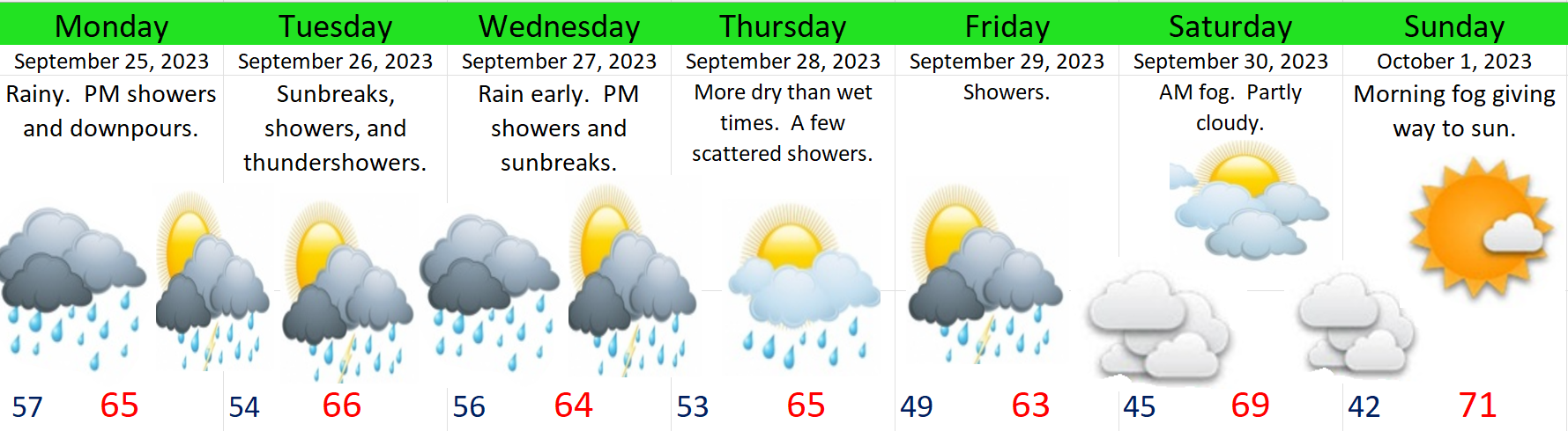
Monday: A very wet day with frequent periods of rain. Late day showers and downpours. Watch for street ponding.
Tuesday: Sunbreaks, showers and afternoon thundershowers. A stormy fall day for sure! Watch for street ponding. Gusty winds 20 to 30mph are possible Tuesday night as another batch of steady rain moves onshore. Nothing too wild, but notably breezier than what we have seen lately.
Wednesday: After a rainy night, most of Wednesday will feature scattered showers and thundershowers with sunbreaks mixed in. Small hail possible. Watch for street ponding.
Thursday and Friday: We should end up seeing more dry times than wet times during these two days. Thursday should only see a few scattered showers with plenty of dry breaks in between. Friday might be slightly wetter with a few more showers, but not a big storm by any means.
Saturday and Sunday: We will end September and kick off October with a beautiful fall weekend. Both next Saturday and Sunday should be excellent days for outdoor events. Morning fog is likely, but with plenty of afternoon sun. Slight chance for showers Saturday, but the vast majority of the day will be dry. Sunday should stay 100% dry, and actually, next Monday will probably stay dry too. Chilly overnight lows though. Lows 42 to 46°.
The Oregon Coast
Waves will dramatically increase in strength and size tonight through Wednesday. No tiptoeing into the storm season this year out along our beaches and headlands. Wonderful wave watching weather, but dangerous if you find yourself too close to the surf. This map shows the maximum wave heights (in feet) expected Monday evening. Looks like 30 plus foot waves out there near the coastline with higher waves out at sea.
The Cascades
No need to worry about snow in the Cascades yet. For now snow levels will remain WELL above our mountain passes.
Okay, enjoy the stormy weather and have a wonderful week!!
We are more than half way through September, and after a rather warm stretch of weather, we are back to a cooler and cloudier pattern.
Highlights and forecast details
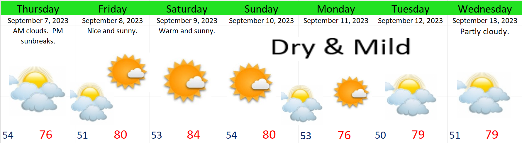
Tuesday: Cool and partly sunny. Basically lots of clouds, some sunbreaks, and highs around 73°. Dry.
Wednesday: Expect a few light showers, but nothing real major by any means, with dry weather for the later afternoon and evening hours. Lingering showers will hang around a little bit longer in the Cascade foothills, but again, nothing real heavy. Highs only around 70°.
Thursday & Friday: More sun, highs in the upper 70s, and dry. Cool overnight temps into the mid to upper 40s. Fall is near….
We have a chance at seeing more widespread showers Saturday, but details are a little “fuzzy” still. For now plan on some wet weather Saturday.
Sunday and next Monday are both still very much up in the air. While the details are still unresolved, what seems certain is next week will be much wetter and stormier. I hope to have time for another update later this week as things clear up, but for now keep in mind that next week will be much wetter.
That’s all for now. Have a safe and wonderful week!!!!!!!!!!! 🙂
We have yet another beautiful week ahead, and I have the forecast right here, but if you have some extra time, I would appreciate if you could read some thoughts I felt like sharing. I steer clear of politics in my forecasts, and to be straight forward with you, I don’t believe I am stepping into politics all that much even in this post. In general it is forecasting weather and getting outside to enjoy it which I love so much; however, I’m not oblivious to the things going on around me, and as we approach the anniversary of 9/11, I feel it is important to share some thoughts as to why America is such a wonderful country to live in.
Here’s the next 7 days
22 years ago already. Do you remember 9/11? I wish to share a few pictures to spark our memories, because it should be more than just a saying. Let us truly never forget the loss of life and the sacrifice our brave and selfless fellow Americans displayed on that day as they tried to save others. It is good for us to feel emotional sometimes about these things in order to help us never forget.
When I see those images, and when I replay things in my mind, I ball my eyes. I cry thinking about the selflessness actions took by so many that day and the huge loss of life. The moms, dads, spouses, brothers, and sisters who never came home that day due to this evil attack. The stories of people showing love and compassion that day are also countless. Heroes on that day didn’t ask people who they voted for first before deciding if they would help. Nor did they ask what their religion was, who they were attracted to, or if they were vaccinated, or what their race was, or any other prequalifying bullshit like we see all too often today. No, they acted like regular decent human beings, and they put other people first with a touch of American heroism and selflessness. On that day we saw people helping other people out. Many people sacrificed their lives for others that day, and we honor them by learning from them, looking up to them, and remembering them.
It is important to me that we remember several things this year on the anniversary of 9/11. Let us remember those things which make America such a wonderful place to live for millions and millions of people. The next time you hear someone ripping on how awful America is, be sure to remind them how for every bad story there is out there, there are a hundred good stories of success, redemption, sacrifice for the common good, and dreams being fulfilled right here in the United States of America.
No other nation tries to do what we do. No other nation has the amount of diversity that we have. No other nation offers the same freedoms, vast tracks of beautiful wildernesses, opportunities, and potential as we have. Show me a nation that has people from all corners of the world living together with freedom like we have here. Do we muddle in world affairs too much and do we have our issues? Most certainly, but do you know what else we do as Americans? We sacrifice, we protect, we care, and we help people in need. When other countries cry out for help or when disaster strikes, we are there to help. Not only our brave men and women in uniform, but volunteers in church groups, non profits, The Peace Corps, and on and on. We are a generous nation. We don’t always get it right, but if you’re focusing only on the bad, then you are missing the whole picture.
This country for many years has been blessed, and if we stop praying for protection and if we stop thanking God for what we have both in the good times and bad, and if we turn our back on what made this country a great place in the first place, then we will fall. If we stay divided arguing over silly things or even serious things alike without ever being able to put those differences aside so we can work together, then we will fall.
We must remember to pray for our nation, pray for our leaders, support our local businesses, be friendly towards people we disagree with, and we must remember it is freedom of religion, freedom of speech, and freedom of expression which are found at our nation’s core.
We hold the power to make our country a better place. We hold more power to affect change than any government policy or politician could ever do. A friendly face, a kind word, a thoughtful tip, and a patient attitude for someone like a busy cashier or waitress can go a lot further for an individual than anything the government could ever do for that same person. It is things like those which help unite us together making us strong, but if we dwell on our differences and the negative things only, and if we continue to fight amongst ourselves, then we will fall.
It makes me so happy to go to a place like the Oregon coast and see people living their best lives enjoying nature and enjoying family, friends, and freedom. It’s in those moments when all of a sudden all those things we argue about in anger endlessly online seem to disappear. Let’s remember each of us are flawed and in need of grace. Let us also remember we all desire some of the same basic things in life: life, liberty, and the pursuit of happiness. Let us focus on those things we have in common and let us remember there really is an evil in the world hell bent on destroying us, and how can we defeat such an evil force if we ourselves are constantly fighting and divided?
A house divided cannot stand. I think it is time we as Americans stand up united again before it is too late for this incredible land we have been blessed beyond measure to call home.
I do pray for God’s hand of protection on this land and its people. As we start a new school year, and as we enter into a new fall and winter season here in the beautiful Pacific Northwest, let us remember to pray, let us never forget how costly freedom is, and let us remember how important it is for us to be responsible with the freedoms we still have.
It’s a great time of year with sunny and mild days, but nice cool nights. I think this is the exact type of weather so many of us Oregonians have grown to love. The forecast is very straight forward with no more thunderstorms or anything wild on the horizon for now, so I say we enjoy the calm weather while it lasts. Here’s the next 7 days: