If you want the forecast, then read this top portion, but if you’re in a reading mood than check out the rest of this post. It’s always an exciting time of year as a forecaster around here. Fall is upon us, we are entering into our storm season, and soon we will be entering into the time of year when snow and cold also become possible. I have a wide gamut of details and fun facts below, but first, the forecast.
Expect showers and sunbreaks on Thursday with increasing amounts of sun later in the day. Highs in the upper 50s to 60°.
Friday looks dry and partly cloudy. High of 59°. Saturday should be a super nice fall day. Patchy fog to begin the morning followed by afternoon sunshine and highs in the low 70s.
Sunday should also be quite mild and nice, and will likely top 70 degrees again. This weekend will probably be our final set of 70 degree days for the season, so enjoy them!! Rain moves in Sunday evening and lasts through Monday. Highs on Monday in the mid 60s.
Tuesday and Wednesday of next week look dry, with sunny afternoons, but chilly and possibly foggy mornings. Lows will also be the coldest they have been all fall down to the upper 30s.
No big storms, no major cold spells, and nothing unusual for the time being.
Weather statistics and the winter ahead
October 1st is the beginning of the new “weather year,” also known as our “water year” for most locations in the western US. It makes sense to have our rainy season fall into one “year” for record keeping as opposed to interrupting our rainy season every January 1st at the start of our calendar year.
To begin with, I wanted to see how this past year compared with previous years in regards to both precip and temperatures. I also wanted to provide a few thoughts for our upcoming winter season.
Let’s start with the precipitation. Check out this graph showing total precipitation for each water year in Salem Oregon going back to the winter of 2003/2004.
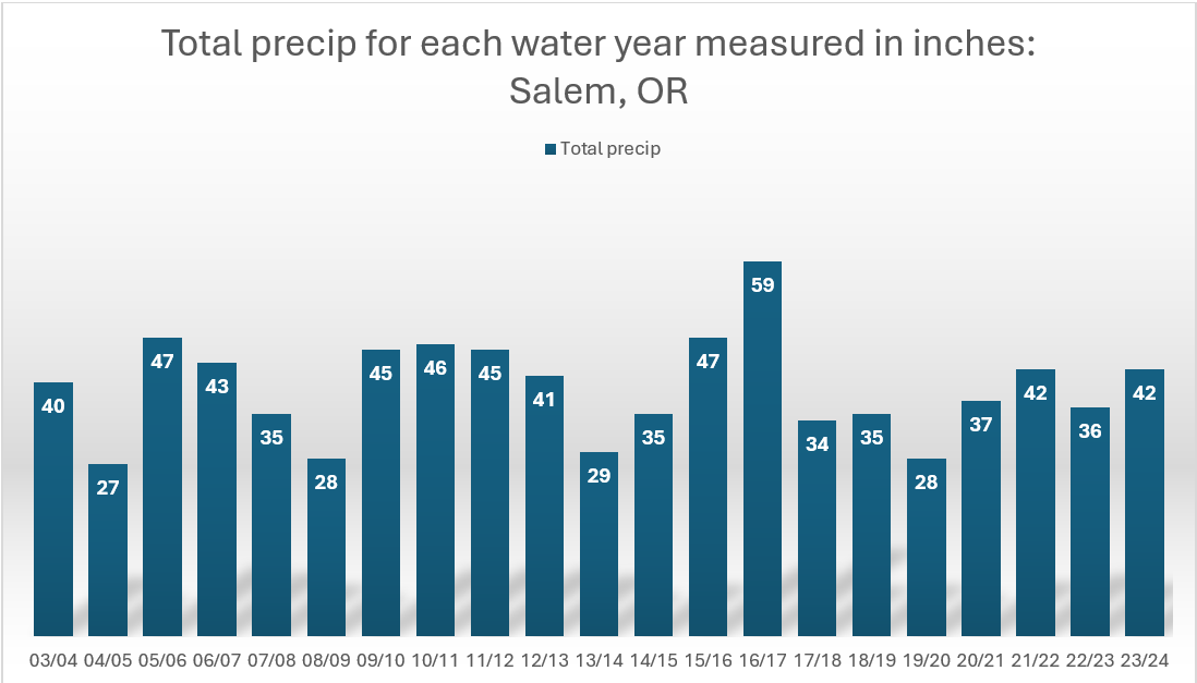
The primary take away is that Salem is rainy lol! It is interesting though how we get our rain one way or another year after year after year regardless of how much the climate may be changing. In fact, one could go back to the late 1800s and early 1900s when our official records began, and you would see extremely similar totals.
For the time being, there is no trend in any direction with precip. There are a few dry years mixed in where we didn’t reach 30 inches, but notice how they are always proceeded by and or followed by a wetter year. Our rain is what keeps this area so beautiful, so remember that later this winter when the rain starts to grow old.
Next let’s look at the total number of days per winter where highs stayed below 40°.
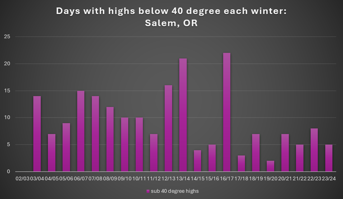
The first thing to point out is the data for 02/03 is not missing. That sad, sad winter really did not have even a single sub 40 degree day. I remember that pathetic winter as a kid. Not even one snowflake fell at our house the entire winter. A huge disappointment for someone who loves snow so much.
The second thing I noticed was how it’s been awhile since we have had a really cold winter, and by that I mean a winter where we experience at least 10 or more days below 40 degrees. Sure, last winter provided us with some extreme cold; however, looking at the total number of days below 40 reveals just how brief and isolated the cold spell was in what was actually a very mild winter. Compare last winter to the winter of 2016/2017 which delivered snow and ice multiple times from December through March, and had a grand total of 22 days with highs below 40°. Perhaps this winter is the year we finally see some prolonged cold again.
The third item I wish to point out is the fact that three of the four lowest totals on the chart were El Nino winters. Currently, we are entering a weak La Nina (more on that below), so I believe we will see at least several days this winter where the thermometer does not reach 40 degrees.
Overall there’s definitely more variability when it comes to cold weather around here than with the precip, but now it’s time to unburden ourselves from what has been. Did I use that phrase correctly??? Anyway, time to talk about what could be in store this coming La Nina winter.
Our up coming winter
We are entering a weak La Nina which means the waters off the west coast of South America are cooler than normal. There are a few other regions of the ocean I look at when finding analog years to compare to. Generally, I look for past winters which had similar ocean conditions as it’s the oceans which really drive our weather.
The map below is a composite of surface temperature anomalies for all the years which had similar ocean surface temperatures. Darker blues are much colder than normal areas, and the red and oranges are much warmer than normal areas.
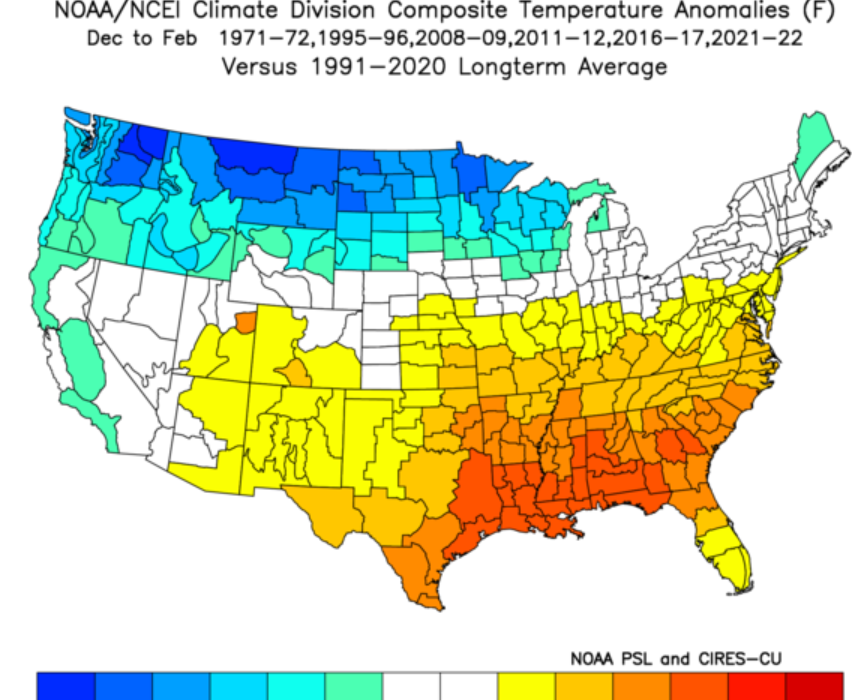
There is a clear signal for colder weather in the pacific northwest during December through February. This tells me we have an elevated chance for colder weather and longer lasting cool weather too. No guarantees, but the deck is stacked in our favor for cooler weather.
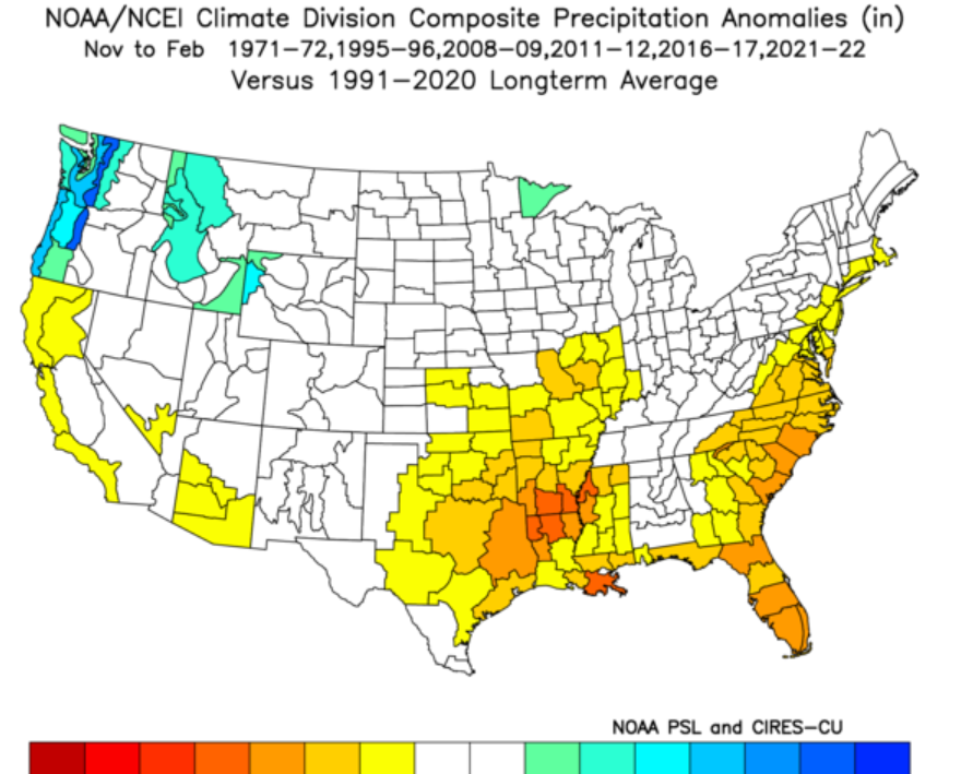
Next we have precip anomalies for the same set of previous winters. There is a clear trend for western Oregon to experience a wetter winter when all is said and done.
Big take aways
I expect our upcoming winter to provide more opportunities for lowland snow. This is something which can be misleading. More opportunities doesn’t always equal lots of snow for a given location in the Willamette Valley. It just means you will likely see snow in the forecast more often than compared to last winter (an El Nino winter), and with those increased opportunities comes increased chances of scoring some decent snowfall.
Last winter really was quite mild with only one big exception. That exception of course being the extremely cold and intense winter storm we saw in January. For nearly 5 days our temperatures stayed below freezing. During that time frame we experienced the sleet/ice storm followed by a few days of very cold weather and then a brief freezing rain event that Tuesday; however, the rest of the winter was fairly mild both in the months leading up to that storm, and in the weeks to follow. I distinctly remember sharing this photo at the end of last December revealing the dismal snowpack at Timberline due to the warmer weather.
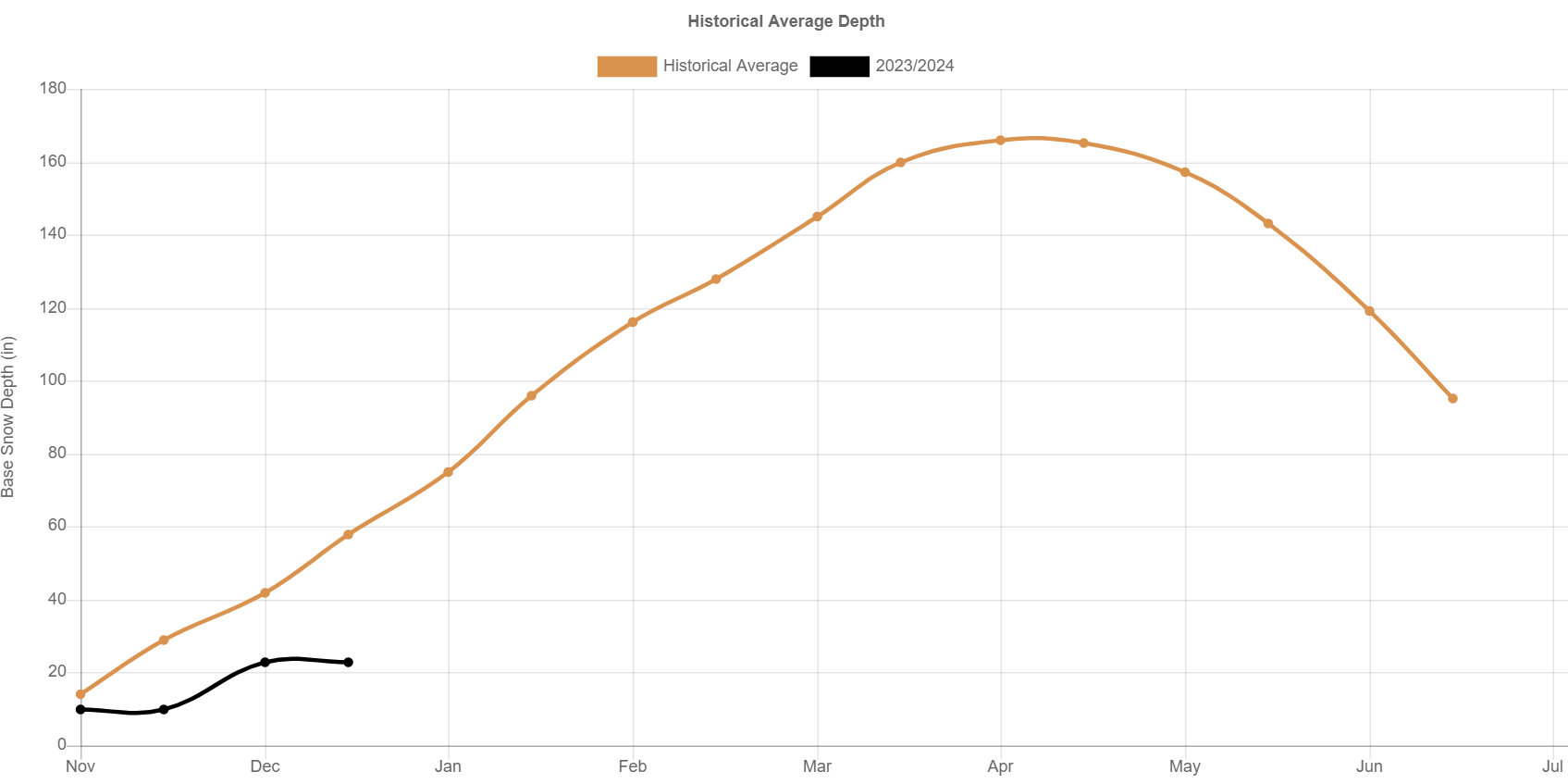
This leads directly into my second point which is I expect the ski season and mountain snowpack to do fairly well this winter. La Nina keeps us on the cooler side of the jet stream more often allowing the snowpack to build up at a better rate. The chart above reminds us just how awful the snowpack was for much of last winter, and that was due to us being on the warmer side of the jet stream for a majority of the ski season.
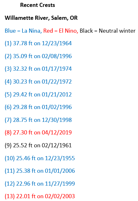
The final piece (which I’ve shared before) is how a La Nina winters often provide us with the correct setup for major flooding on the Willamette River. I’m not predicting it, but it’s also not a coincidence that the vast majority of our highest river crests on the Willamette have occurred during a La Nina winter. I have shared this before, and it’s still up to date I believe.
It’s also a really good reminder to be ready and prepared for a natural disaster as much as possible, and assume you may be on your own for a period of time following a flood or any other type of disaster for that matter.
The main message is expect more opportunities for snow, higher chances of seeing cold weather, a decent ski season and mountain snowpack, and an elevated chance at seeing major flooding.
Stay safe, stay healthy, and enjoy the weather regardless of what it brings! 🙂