
March has always been a battleground month. Just look at today. The first half of the day was so nice with ample sunshine and mild temperatures. At 3:30pm we were at 57°, but then clouds thickened up, winds shifted direction, and a few showers moved through. Temps are down to the mid 40s as of 10pm, and will continue to drop through the night. I’ve got a look at the week ahead, plus another update for the Cascades below that.
Details
Mon: Showers with sunbreaks. A few heavier showers possible including showers with small hail. Morning low of 37°, high of 49°.
Tue: Very similar to Monday, but slightly colder start to the day. Low of 34°, high of 47°.
Wed – Fri: Frequent periods of rain, and cloudy even when it’s not raining. This will be a gray and gloomy three day stretch. Steady rain and thick cloud cover will keep temps in the mid 40s at night and low 50s during the daytime hours. Terrible weather for outdoor sports, activities, practice, etc. The rain will have a sharp south to north gradient. Locations further north will see more rain this week whereas the south Willamette Valley may actually stay fairly dry.
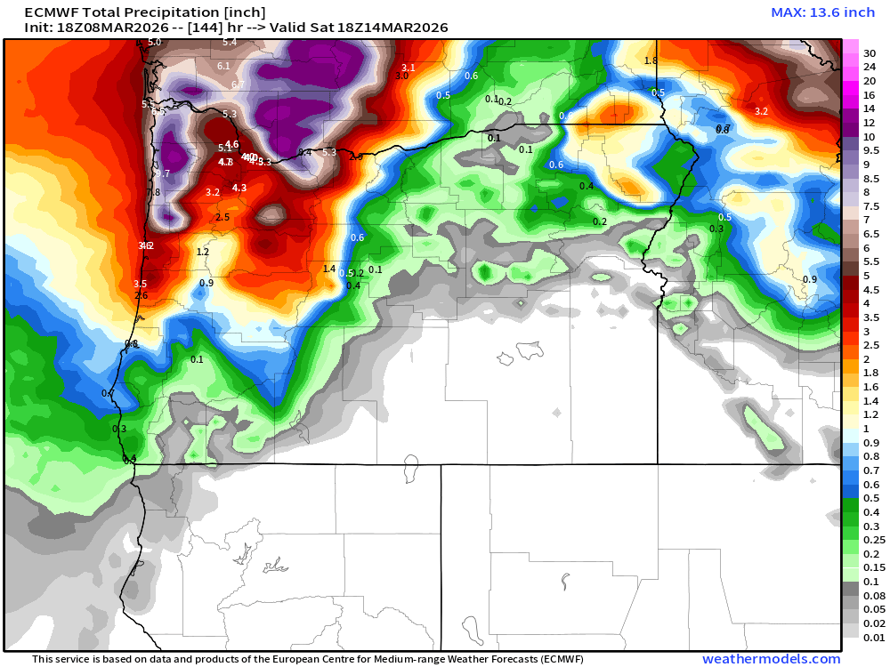
The map below shows precip totals through 11AM Saturday morning. Eugene coming in with just under an inch of rain. Salem at 2.5″, and the Portland metro around 4+ inches!
Wet weather continues right on through the weekend. Saturday afternoon and evening could be mostly dry and even sunny, so not all hope is lost, but rain seems likely for Sunday.
The Cascades
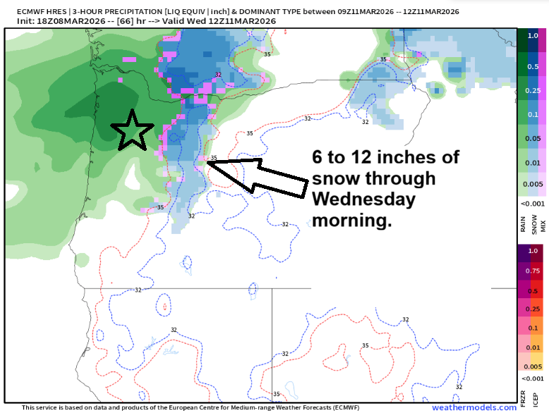
The first half of the week looks great for the northern OR Cascades with low snow levels, and frequent snow showers adding up to 6 to 12 inches of snow through Wednesday morning. Plan on snowy roads through at least mid day Wed. The map below shows us 5AM early Wednesday (green is rain, blue snow, and the star is roughly our location in Salem) artistic, I know. 😉
But then the jet stream lifts north Wednesday afternoon and remains north through Friday night. Periods of light rain will fall at our ski resorts Thursday and Friday leaving the passes wet. Saturday could be rainy too, but there’s hope on some of the weather models that the cold air will push south again turning the precip back into snow up there just in time for the weekend. Hoodoo is back down to just 18″ at their base as of Sunday evening. My goal is to update you all midweek with better details concerning the weekend.
For now, have a safe and great week!
