Did you enjoy the warmer/hotter weather? It’s getting to be that time of year where we have more and more warm and sunny days and fewer rainy days. Our toasty high temperature of 91° on Friday actually fell short of the record for the day. Back on April 28th, 1926 Salem reached a scorching (for April) high of 93°. Of course, if you’ve been outside or had any windows open then you know we are done with the heat for now.
The forecast for this week is a bit tricky as a cutoff low is expected to send waves of showers over the area at sort of random times throughout the week making my job difficult. I’ll do my best to provide details, but keep in mind that timing of these showers will be extremely hard to pinpoint.
Main message
Monday through Friday: Same routine almost every single day with a period of rain or showers, but with lengthy dry breaks in between. This type of pattern is a decent thunderstorm producer too, so don’t be surprised to see a storm at some point this week. I have details for each day below:
Today and Monday
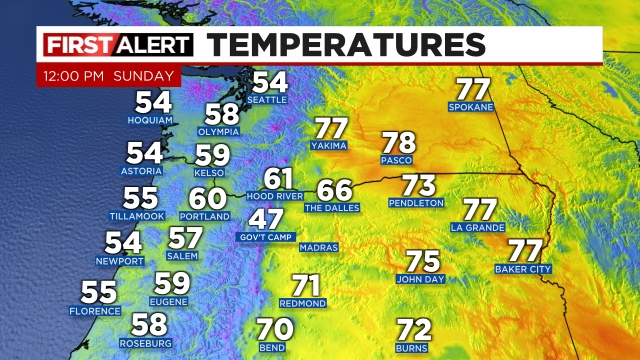
A lot of clouds, noticeably cooler, but should stay almost completely dry. Theses two days have the smallest chance for rain of all the days this week. Highs in the low 60s. As of noon today most places west of the Cascades are still in the upper 50s. Nice and warm east of the mountains though. 🙂
Monday night/Tuesday
This timeframe will feature our first real shot of seeing rain or thunderstorms. Highs on Tuesday should reach between 70 and 73°.
Wednesday
This day is currently looking mostly – if not totally dry. Expect highs in the low 70s. 🙂
Thursday
I’ve seen a lot of signs indicating this day will feature more showers with an elevated threat for thunderstorms. Highs in the mid 60s.
Friday
Cooler and cloudy with showers likely. Highs barely reaching 60°.
Expect similar conditions for next weekend too. Not a washout, but not totally dry either. Meanwhile, up in the Cascades it will be too warm for snow this week, so no concerns for snowy roads; however, heavy rain at times from thunderstorms could still cause travel issues if you find yourself up there this week.
Have a great rest of your day!!!