
We are wrapping up day 2 of what will be one of the longer heatwaves we have seen in a few years. No, not the hottest (that title will likely remain with June 2021 for quite awhile), but it will be a very prolonged heatwave. Yesterday Salem reached a high of 94°, and as of 5PM today, we have reached 100°. Phew! Check out the toasty hot temperatures dominating the Pacific Northwest.
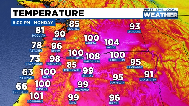
There is relief right along the coastline; otherwise, the rest of the northwest is baking (and will continue to bake) under the hot July sun. The sun below pretty much sums up the extended forecast. There are just a few highlights I wish to share with you before wrapping this post up.
1.) Nights will be unusually warm due to increasing humidity which will make it really tough to cool your house down with just open windows. Lows will bottom out 62 – 65° tonight through Monday morning of next week! Yes, it’s really going to be a long stretch of extremely hot weather!
2.) The length of the heat is my 2nd highlight. Highs anywhere from 96 to 102° are likely through Saturday with lower 90s continuing into early next week.
3.) Hang in there because much cooler weather should be arriving sometime around August 2nd or 3rd.
Stay cool, check up on people who may not have AC, and keep hydrated!!
