Thunderstorms today

We have a fairly decent shot at seeing thunderstorms during the late afternoon and evening hours here in the mid valley.  Between now and roughly 4pm partly to mostly cloudy skies & increasingly mild temps will rule the day.  The warmer we get today the better chance we have at seeing thunderstorms later on this afternoon/evening.  You can keep track of  how warm our temps are getting right here on this handy dandy link provided by Fox 12’s Mark Nelson. 
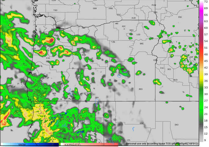
Next I have an image of the simulated radar good for 4pm local time.  The oranges and reds indicate storms right over the valley.

thunderstorm chances 5.18

As is typically the case around here, not everyone will see an actual thunderstorm; however, chances are high you will at least get some heavier rain and possibly gusty winds.  Best guess at timing of storms is 3 to 5pm.

In the meantime enjoy the dry weather!

Unusually cold tonight

We have some chilly temps coming for us tonight which means you might want to cover up or bring inside your warm weather plants.  Temps should fall down into the mid 30s with some spots approaching the freezing mark.  It’s most likely a one shot deal as low temps modify slightly for the rest of the week staying closer to 40 – 43°.

Don’t be fooled

It’s nice and dry right now, but don’t let that fool you.  Showers and maybe even a thunderstorm or two are beginning to develop to our south and will head into our area later this afternoon lasting through the early evening hours. 

If you’re bored and have absolutely nothing to do, or if you are a weather geek like me, then feel free to track the showers on the radar as the develop and head our direction. 

Quick update

It’s cold outside and getting colder, but it’s super dry.  I’ve checked both the radar and satellite loops and neither one shows a lot of moisture at all.  This means very little ice or snow tonight and tomorrow morning.  It doesn’t take much to make roads icy, so still be careful tomorrow morning and be ready for delays just in case, but I’m really not expecting very much to fall.  My updated forecast for now through 10am: nothing to 1 inch of snow and ice tops.

Wednesday afternoon and evening:  Precip will increase dramatically during the afternoon hours and much of that will fall as either a rain/snow mix or wet snow.  As stated in my previous forecast: no sticking snow until 5 or 6pm at the soonest due to the warmth of the day.  After sunset anyone could pick up a dusting or so.  More snow the further east in you live  (ie. Stayton, Scio, Silverton ect.)

Snow moving in

Reports coming in now of snow falling in Corvallis, and even southern portions of Salem.  Eugene is well on its way to having another snowstorm with moderate to heavy snow falling there.  All of this will push northward through the evening.  Temps are generally 32 to 35 degrees and will fall below freezing soon.  I’m feeling more confident we all see somewhere between 1 and 3 inches, and maybe even more as I see a healthy stream of moisture feeding into the storm.  So we will see…

Enjoy the “storm” and be safe!

Another snow event

First off a quick little demonstration on how a little bit of elevation can make a huge difference in weather conditions. This first pic is from roughly 200′ in elevation.  The next pic is my neighborhood at 475′ in elevation.  Both pics were taken Monday morning.


Moral of this story is that snowfall totals can vary quite a lot even right here in Salem/Keizer which is just another reason why predicting snowfall is such a pain.


Moving on, I’m tracking another snow event heading our way with some factors working against us seeing a bit of snow and some factors working in our favor if you’re rooting for more snow.

One factor working against a lot of snow tonight would be this dry air.  Dry air means precip has a tougher time reaching the ground.  Another factor to consider is this storm has less moisture than the last storm which again equals less snowfall potential. 

Working in our favor for a bit of snow are the cold temps.  Across the region we are a solid 3 – 6 degrees colder than this exact time Sunday.  This means it will not take long at all for snow to begin sticking this go around.  The second factor working in our favor for more snow is the trend.  They say “the trend is your friend,” and the trend on the weather models today has been increasing the precip tonight.  This of course means the opportunity exists for us to exceed current snow forecasts including my own.

With all that said I expect many of us will receive somewhere between 1 & 3 inches of snow.  Sadly, there’s almost always a “loser” when it comes to snowfall in these parts, and I imagine some of you will see less than an inch.  Either way be prepared for area roads tomorrow morning to be icy, slushy, and or snowy.  It’s late February though and the roads should be just wet by mid to late morning thanks to the increasing sun angle and longer days.

I should have an updated look ahead and a quick update on tonight’s storm later this evening.

Be safe

Wet night. Wet weekend.

Rain is moving into the Salem area and it’s going to be a damp evening. 

No fancy graphics tonight, but keep your eyes peeled for a nice detailed updated tomorrow morning/early afternoon.  I’m sure you have heard more rumors of snow, and there’s a lot to cover, and there’s a lot of possibilities.  Just know that Monday through Thursday of next week look very chilly and very wet, and there is a decent chance we see some sort of snowfall.

Again stay tuned for a nice updated tomorrow!

Oh and one more thing…   The Cascade passes and the Gorge will be very snowy pretty much now through uhhhh well for a long time, so be prepared when traveling in those parts.