Thunderstorm chances increasing

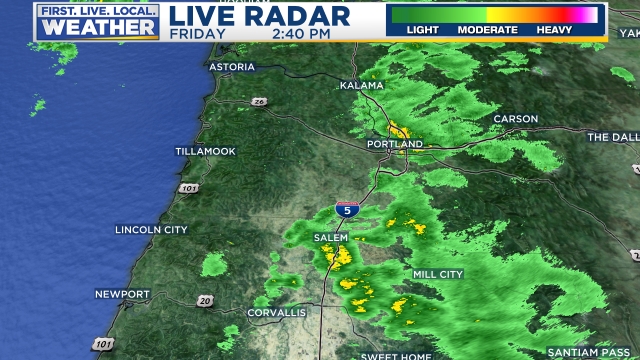
As expected the sunbreaks today are destabilizing the atmosphere enough that we are seeing some hefty showers and thunderstorms forming around the region.  No guarantees we see a storm as they will be scattered in nature, but our chances are definitely much higher than usual.

I have a couple of links to help you keep track of the storms today.  This first link tracks lightning strikes:

https://www.lightningmaps.org/?lang=en#m=oss;t=3;s=0;o=0;b=2.31;ts=0;z=6;y=40.2236;x=-116.0707;d=2;dl=2;dc=0;tr=0;

This second link is to the radar which updates every ten minutes.  Click on the map for a closer look.

Tomorrow should be a near repeat of today with the only difference being a few more sunbreaks, but still a chance for showers and storms.

Have a fantastic Sunday and be safe!

Thunderstorms

If you have lived here any longer than say a year or so then you know how difficult thunderstorms can be to forecast around here.  Take for example this evening.  Right now we have one isolated/random thunderstorm NW of Salem.  Looks like another one SW of Salem may be popping up, but you get the idea.  Some of us will score a nice storm and some will not.

5.10.20 thunderstorms one

Details

To keep it short, we have a fairly decent shot at seeing thunderstorms now through Monday night.  Monday won’t be a washout, in fact there should be plenty of dry breaks mixed in, but if you find yourself under one of the stronger storms rolling around then you will see a brief period of heavy rain.

Tuesday – Thursday will feature plenty of showers, sunbreaks, and additional opportunities for thunderstorms.

Fri & Sat:  The driest days this week with highs around 72°.

Sun:  A return of stormy weather looks likely at this point.


I hope you all had a wonderful Mother’s Day and a great Monday!!

Oops!

Showers today were not in the forecast I gave a few days ago.  OOPS, and sorry!  What else can I say?  Yes, even the best forecasters mess up every now and then… This is how the radar looked around 2:40PM showing a number of showers roaming around.

uh oh 5.1.20

FORECAST 

Moving on from today’s little fiasco I see Saturday has the potential to be rather stormy with a cold front moving through during the morning hours bringing gusty winds, heavy rain, and even the possibility of lightning and thunder.  Behind the front a few sunbreaks should pop up along with additional showers and thunderstorms.  Some of these thunderstorms could be quite strong for our corner of the world.  Something to keep in mind if you are out and about tomorrow.

Sunday.  Currently I suspect much of the day will be dry and even sunny, but a few afternoon showers and thundershowers will pop up again giving anyone the chance at seeing a brief downpour.

Next week could feature our warmest weather of the year specifically towards the second half of the week, but more on that another day.

Have a wonderful rest of your Friday!


Fun times

A quick Saturday afternoon update.  It appears as though most everyone received at least a little bit of slush last night and some of us had a solid dusting of snow.  Here’s what our backyard looked like in south Salem around 7:10 AM.

20200314_071144

For the remainder of the day we will see more cold rain showers and sunbreaks with plenty of ice pellets and snow mixed in at times, and maybe even a flash of lightning.  In fact there have already a few strikes down south of Salem.  Here’s a link to the latest radar image:

Tonight:  Anyone could see an isolated snow shower or two.  The other thing to watch for is icy roads.  With showers falling today and colder air moving in I expect icy roads across the Willamette Valley this evening, so use caution while traveling tonight.

Sunday:  Other than some isolated spots of snow, the day should end up mostly dry with plenty of sun.  Slight chance for an evening shower.  Highs close to 50 with a chilly breeze.

Monday:  Temps will start out in the mid 20s which is cold enough to possibly set some new record lows, but it’s mid March which means even with the cold start we will still warm up into the upper 50s by the afternoon.


Slight chance for snow

We have mostly clear skies, a cold atmosphere, and moisture is expected to move in between 3 and 6am tomorrow morning.  This setup could give anyone a quick coating of snow.  I’m not expecting a lot (or any at all), but the possibility exists and I figured I would mention it.  Icy roads are also possible this evening.  I see that temps are already around 35°F and will likely be below freezing by 8pm.  After a disappointing lack of snow this week it would be nice to at least score a slushy dusting (maybe more) tomorrow morning.

By 11am we will likely be too warm for any more snow, so this will be a quick hitter if it even hits at all.

We will see what happens,

Happy Thursday night!!

Watch for icy roads

First off, we had the world’s shortest snowfall Saturday night.  For roughly 20 – 30 minutes it snowed in Salem.  Some nice big flakes, but the snow didn’t really stick, and within an hour it was nothing more than a cold rain.  Regardless it was still exciting if you had the chance to see it.

Moving on I see the chance for some icy roads Monday morning IF we clear up tonight.  We are currently at 37 degrees with cloudy skies.  If we clear up overnight temps will have no trouble dropping below freezing which means the wet pavement from the showers we had this evening would likely ice over.  Something to watch for as you head out the door in the morning.

I’ll likely have an update on the extended forecast in a day or two, but honestly it’s not looking exciting at all…  Mostly dry and cool weather will dominate this week with very little rainfall.

Have a great Monday!!!