For the first time in over 40 days, we finally have rain and showers in the forecast. Western Oregon has been incredibly dry with locations like Los Angeles having seen more rain than we have since May! Anyway, things are finally changing.
Here’s a look at the next 7 days.
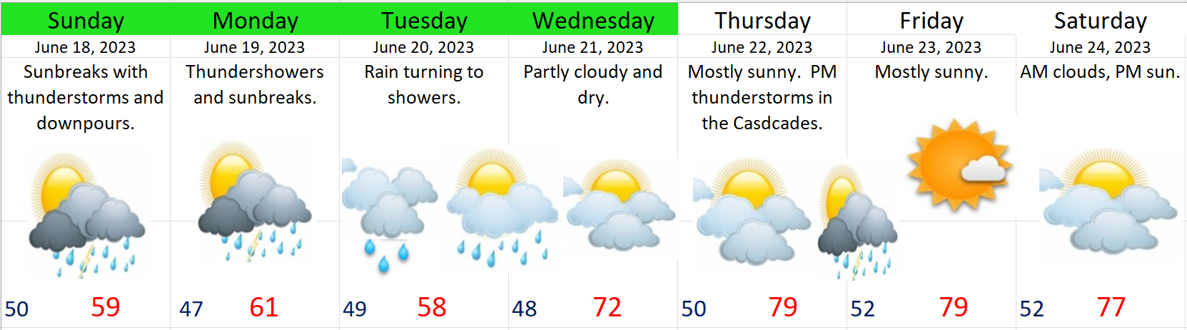
Today: Mostly dry. Probably not much more than some isolated sprinkles.
Sunday: WET. The action picks up a bit with showers and even some thunderstorms moving through the region. Some really nice downpours. Unfortunately, they will be just in time for Father’s Day…
Monday: WET. More thunderstorms and downpours with sunbreaks in between.
Tuesday: WET. Steady rain morning rain will transition into a few afternoon showers.
Wednesday: DRY. Temps should climb back into the lower 70s with partly cloudy skies.
Thursday – next weekend: DRY. Lower confidence for this time frame as we will be on the edge of a pesky upper level low. In “English” that means we could see some thunderstorms drift over our region if the low sets up in the right spot. Too far away to know yet. For now I’m going with a mostly dry forecast, but still hanging on to a slight chance of thunderstorms. Temps will be warm with highs close to 80. Chance for thunderstorms will be highest up in the Cascades. Even if we do see a storm during this period of time, the majority of these days will still be dry.
Happy weekend, happy end to the school year, and happy Father’s Day! 🙂