We have a more springlike pattern setting up today, and I figured it was well past time for at least a quick update. 🙂
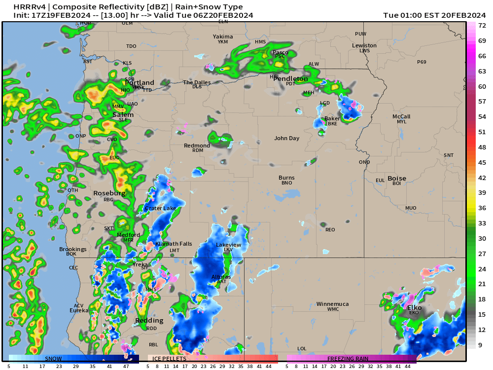
For the remainder of today expect mostly dry weather. This evening heavier rain showers and even some thunderstorms are likely as we are on the northeast side of a strong upper level low. This is a classic summertime thunderstorm pattern, but being that it is only February, I’m not sure how strong the storms will be. Regardless, expect heavier rain at times this evening. Here’s the estimated radar image for 10pm tonight showing some of those stronger storms pushing through the region.
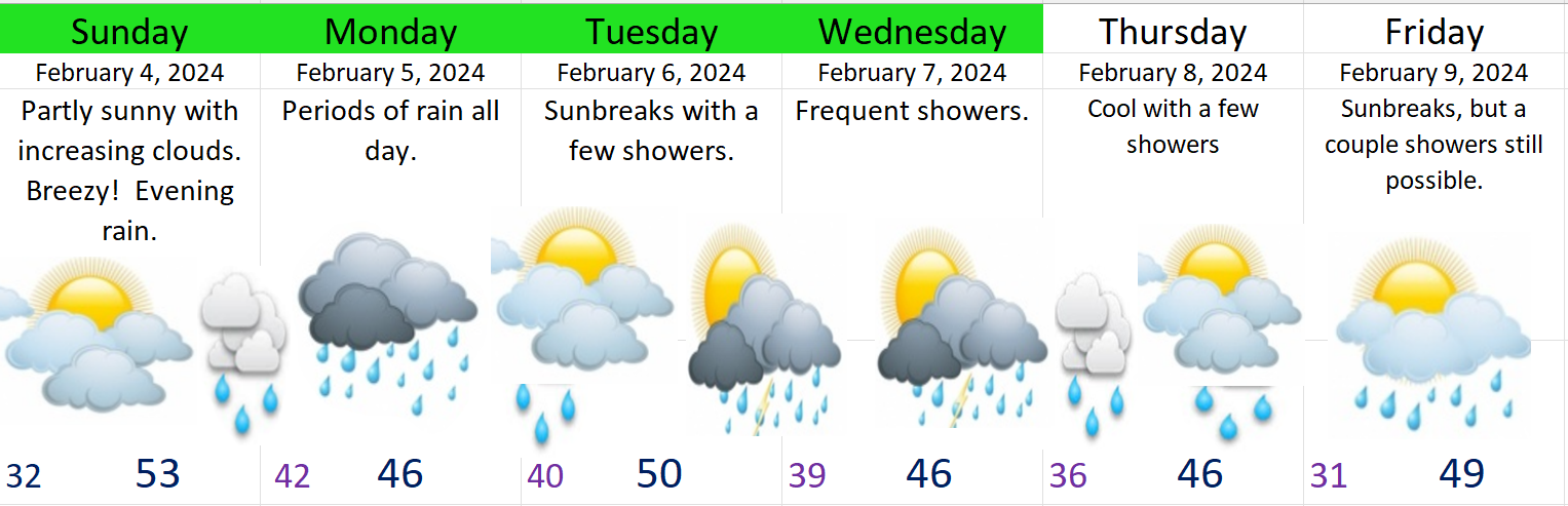
Both Tuesday and Wednesday will be showery with sunbreaks mixed in. Some fairly heavy showers still possible both these days as well.
Thursday should be mostly – if not completely dry with highs in the mid to upper 50s.
Friday & Saturday are looking great for late February. Dry and partly cloudy with highs around 60°.
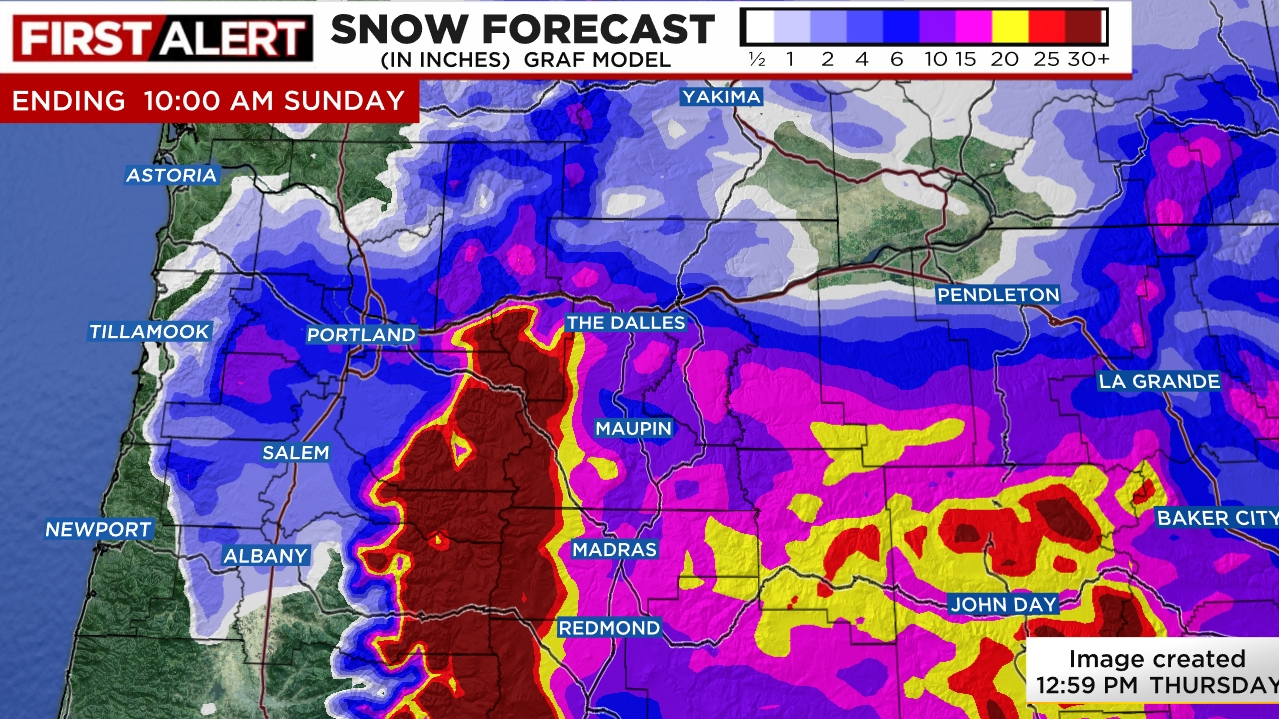
Next Sunday a powerful cold front moves onshore ushering in cooler weather and bringing heavier rain and lots of mountain snow.
January was a wild month, but things have calmed down lately. We have seen some really nice days with the tail end of January being especially mild. Salem set a new record high of 66° for the date of January 28th missing the all time January record of 68°. Today turned out to be a fantastic day as well. It honestly felt like March rather than the beginning of February.
Sunday is looking nice, but not quite as amazing as today was due to two reasons: 1.) Gusty winds of 20 to 30mph develop as the day goes on which will provide an extra chill to the air. 2.) Clouds will be slowly moving in all day long with rain arriving by dinner time (5 to 7pm).
Here’s the next several days with details below.
Monday: Drippy and gray with periods of rain throughout the day.
Tuesday: Sunbreaks with a few showers or downpours possible.
Wed & Thu: Both these days will likely be on the showery and cooler side. Downpours of rain and even some hail likely both these days.
Friday: Slight chance for showers as we stay in a cooler pattern.
The Cascades
Snow levels will remain at or below pass levels Monday through Friday. Not a lot of snow, but anywhere from 2 to 6 inches each day should add up helping out the snowpack a little and making for some nice skiing weather really all week long and into next weekend too. Snow levels will be at their lowest Wednesday and Thursday. Perhaps down to 1500′.
What a soggy stretch of days we have had lately. LOTS of rain and some big time downpours earlier this week – most notably on Wednesday. For the entire month of January we are closing in on almost 9 inches of rain here in Salem. That’s a lot, and a little more still to come.
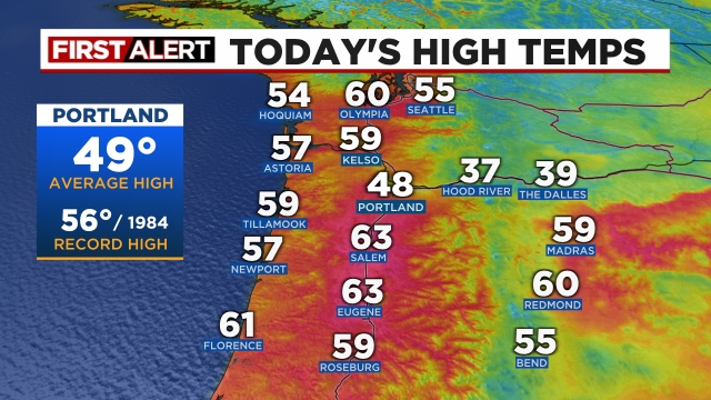
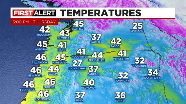
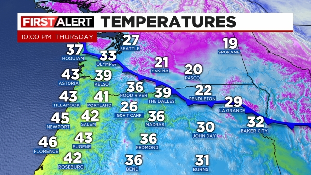
Temperatures have become increasingly mild as well, and anyone outside today surely noticed. Take a look at the high temperatures across the Pacific Northwest for Saturday.
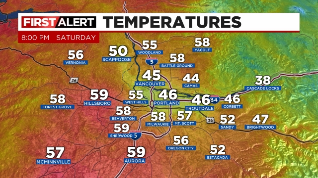
Next take a look at the local effect the Columbia River Gorge is still having on the Portland area. As of 8pm a “cool” easterly breeze is still keeping PDX, Troutdale, and locations right near the gorge cool while the entire rest of the region is in the upper 50s. Kind of neat to see the effect the gorge has on the area.
Both Sunday and Monday look to be about as nice of days as you can get this time of year in regards to both temperature and lack of precip. Sunday will feature a chance for a couple isolated showers, but for the most part ample sunbreaks SHOULD rule the day. Highs Sunday will likely top out in the mid to upper 60s! :) Monday will be similar, but slightly cooler with highs closer to 60 degrees which is still plenty warm for the end of January. By the way, our warmest January temperature ever recorded was 68° in 1899. Will we break that record? Time will tell, but it will definitely be mild.
Enjoy it, after all it is still winter, and we know for certain cooler and wetter weather will return with time. In fact we know that time will be later this upcoming week lol… :) Tuesday might have a shower or two with highs in the mid to upper 50s, but the rain returns in full force Wednesday. By Thursday cooler temperatures will also return accompanied by mountain snowfall.
The Cascades
Terrible skiing weather through Wednesday, but all signals indicate a return to much cooler weather along with fresh mountain snow and low snow levels Thursday through next weekend. So hang in there because good skiing weather will return shortly!
I hope you all can make the most of the nice weather!! :)
We have had some extremely cold and wild weather lately, and I can recap that all another time, but for tonight I want to make sure you all are aware of the freezing rain potential on Tuesday. This will create more problems; however, we are expected to warm back up by Wednesday morning as regular rain and milder winds move through the region, so the end to this bitter arctic airmass is in sight.
Tuesday: At some point early Tuesday afternoon flurries and ice pellets will begin falling. It won’t take long to convert over to freezing rain though, and by 2 or 3pm freezing rain will be falling across the mid valley. Freezing rain should last here in Salem until at least 9pm, but it could go on for even longer. It’s always tough trying to figure out exactly when those “warmer” southerly winds will reach us, and sometimes cold air is stubborn and slow to leave.
The further north you go and the closer to the gorge you get, the longer the frozen precip will last.
It’s been a full weekend for me, and I may or may not post tomorrow. So for now plan on freezing rain disrupting your lives beginning early tomorrow afternoon and lasting through the evening hours, and prepare for some power outages as well.
In case you are short on time, here are the most important headlines:
The Salem area freezes up late Friday morning or early afternoon at the latest with snow showers turning roads snowy and icy.
A major winter storm will effect us Friday night through Saturday night brining widespread snow and freezing rain along with power outages for many.
Very cold (sub freezing) air remains in places through at least Tuesday or Wednesday of next week.
Details
We are closing in on what will be one of the largest winter storms we have seen in years. This storm will likely bring both ice and snow to the Salem area with an intense cold as well, and will continue to effect your life for several days to come.
Friday: This is important!! It is increasingly likely that Salem freezes over during the late morning or early afternoon hours. We will probably see snow showers here in Salem while the bitter cold arctic air begins to move in. Roads could turn snow covered fairly suddenly which will quickly make travel very difficult. Even if we don’t get snow initially, roads will turn icy as the temp drops. Our high temperature Friday will occur in a few hours when we hit midnight. Temperatures will continue to drop from there on out.
Here’s the forecasted radar for Friday at 2pm showing snow showers around Salem and even points south already:
Check out the progress of the cold air. I have the 3 and 10PM temperature maps from the PNW. You can see the progress of the cold air advancing southwestward toward us with Seattle now under the influence of the arctic airmass.
Friday night through Saturday night:A major winter storm rolls across the entire region. Freezing rain, sleet, and snow will fall between Eugene all the way up to Portland and out along the coast even for locations north of roughly Waldport or Newport. Eugene and Newport up to about Lincoln City and Albany will probably be in the freezing rain zone most of the time. Albany, Salem and Woodburn will probably see a “good” mix of freezing rain, sleet, and snow. That will be a real mess!! North of Woodburn should mostly be snow the whole time. This storm should end during the overnight hours early on Sunday. Temps will hold fairly steady in the lower 20s all day long. That’s right, temperatures 20 to 23 degrees coupled with breezy north winds plus snow and ice falling all day long will make for the coldest day we have seen in years.
How much snow or ice? This is always tough as the exact depth of the cold air and how much moisture falls ultimately determine this, but here’s my best guess for Salem specifically. I’m thinking 2 to 6 inches of snow and a quarter of an inch to 3 quarters of an inch of freezing rain. In general, the more snow we get the less freezing rain we will receive and vice versa. If we end up getting more snow (like 4 to 6 inches), then we may avoid significant power outages here in Salem. Either way, Salem will be shutting down for a few days as roads will be covered with snow and ice.
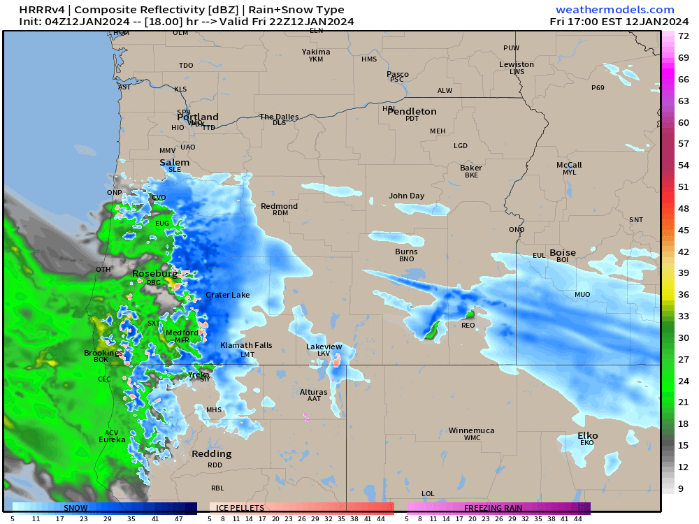
This estimated radar image shows the various wintry weather precip types for Saturday at 11am. Blue is snow, and the salmon like color is a mix of snow and ice, and the purple represents freezing rain.
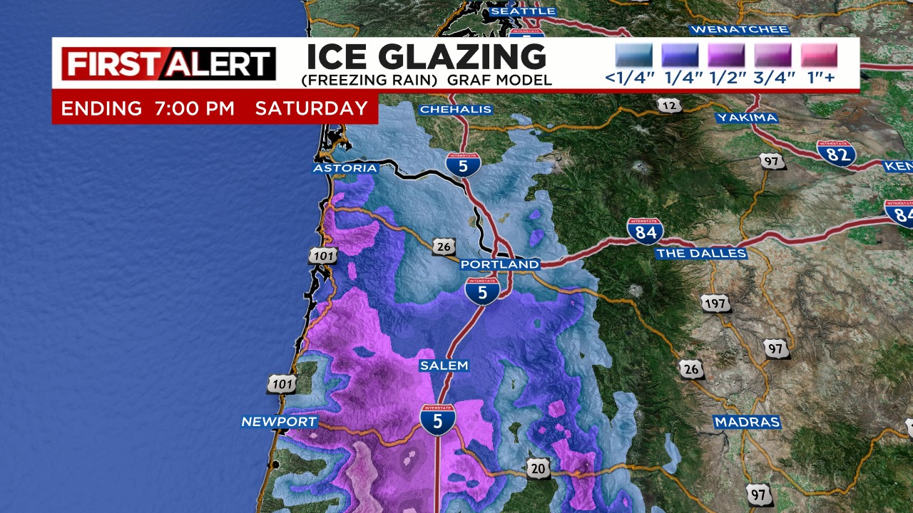
This next image shows estimated ice accumulation. Those purples south of Salem are totals over half an inch. Not good for those areas.
This next image shows total snowfall for the storm. This shows Salem receiving several inches of snow, but a small shift in things could give us either more ice or more snow. Put those maps together and you can see why we have a big frozen mess on the way!
Sunday: Frigid! Highs 27 to 29° Lows Sunday night into Monday morning 13 to 16°.
Monday: Clear skies and sunny and super cold. A high around 30 to 32° and a low temp Monday night around 10 degrees F.
Tuesday: We SLOWLY “warm up to freezing after an absolute frigid start to the day. Highs might even crack freezing this day, but not by much. I’m going with a high of 32°.
Extremely short post. Fun charts, graphics, and details in a post later tonight.
We have a major winter storm heading our way for the entire Willamette Valley.
Here in Salem expect frigid arctic air to move in at some point during the late afternoon hours. If you can work from home, tomorrow would be a great day to do that. There is a decent chance much of the day is fine; however, this arctic airmass has teeth to it, and once it hits, things will freeze over with snow expected across the entire region.
Like I said, more details tonight, but plan on today being the last “regular” day for quite some time. Snow, freezing rain, and sleet are all expected here in Salem. Expect snowy and ice covered roads and significant and widespread power outages to begin late Friday afternoon/early evening. These nasty conditions and power outages will last at least through Monday or Tuesday. This storm its self is really big and frozen precip will continue to fall through Saturday night. Temperatures will not rise above freezing probably until Tuesday at the soonest meaning this will be a very SLOW thaw.
Make preparations, run errands today or first thing tomorrow and be ready for a wild several days.
Last night’s cold front was intense. Salem observed an official wind gust of 41mph, and several local stations reported gusts up to 45. Over half an inch of rain fell last night too. Many locations picked up a little bit of hail today, and NE Salem up through Silverton even had a brief thunderstorm. My students got pretty excited when they saw they lightning strike earlier today. :) Meanwhile, the mountains have picked up feet of new snow and will continue to do so for basically the rest of the week.
The forecast for tonight
What’s going on tonight? There is a low pressure tracking right towards us. Typically this would be no big deal as it would usually just bring rain to people both north and south of the low pressure. However, since the atmosphere is cooler than normal, plus it’s the dead of winter still, the exact track has large implications on what happens here. Currently, this is what I’m expecting.
Heavy rain or a rain snow mix in Salem and Keizer with gusty winds at times. Maybe slush in the highest hills, but we should stay all clear as far as impact on our roads.
A brief period of heavy wet snow will fall from roughly Wilsonville northward. Bullseye seems to be right around Portland. All locations from Wilsonville north through Portland could see anywhere from 1 to 5 inches of heavy wet snow beginning around 9:30PM, and should be done by 1AM or so. Any valley locations that receive snow will actually warm back above freezing probably as soon as the storm ends. This is not a long lasting storm.
Even if the storm tracks further south, I still see Wednesday as being a regular cool and wet day with showers, downpours, and sunbreaks. Any snow that falls will melt away quickly. No big impact on your Wednesday is expected.
Thursday: More showers and sunbreaks. Brief downpours, maybe some hail, or wet snow mixed in, but nothing too wild.
Friday – Sunday: Plan on cold arctic air moving in Friday afternoon or early evening. This will set the stage for what could be a major snow or ice storm. Let’s get through tonight’s action first, but I’m telling you now, expect snow and ice to disrupt your plans Friday evening through Sunday. The snow and ice this weekend will likely cover all areas from at least Salem northward.