Rainy and cold weekend

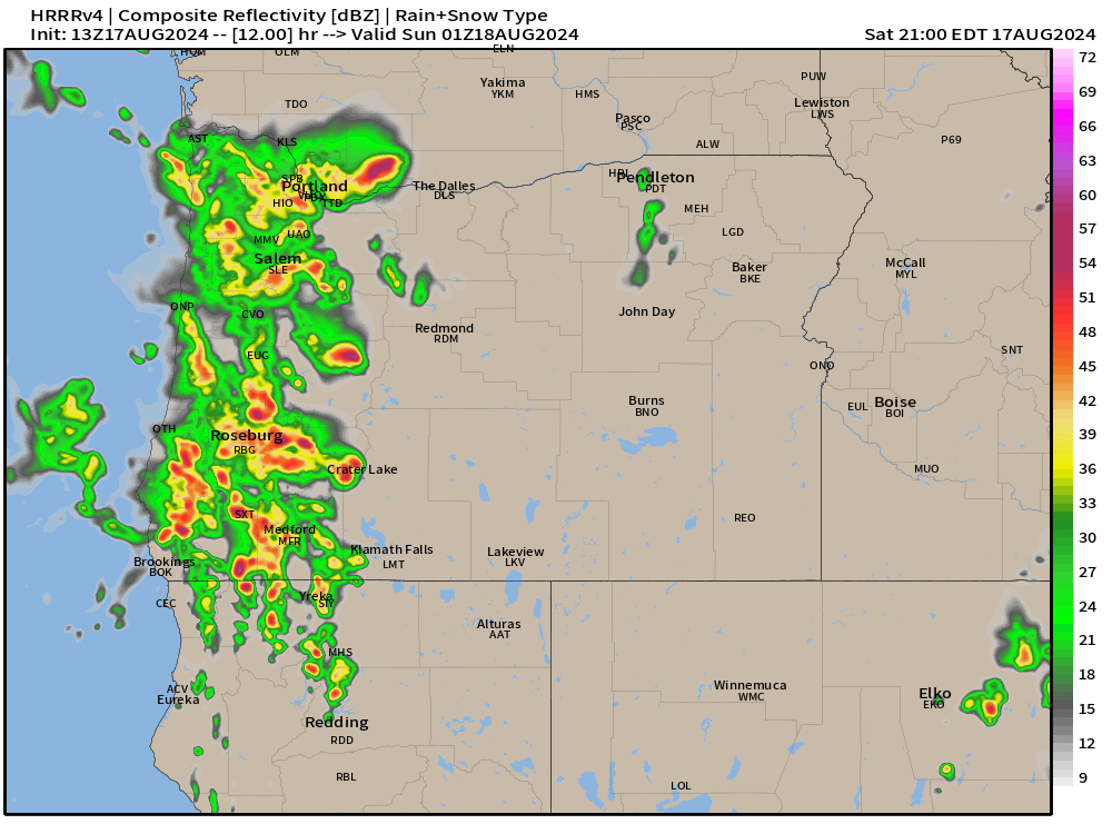
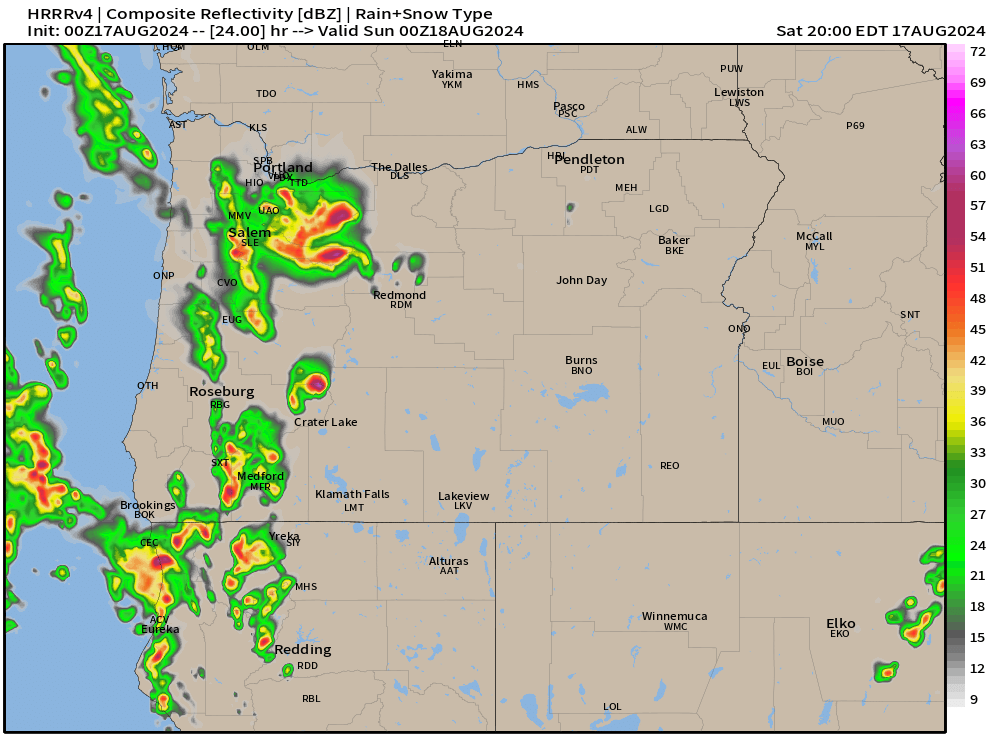
We have a full on washout occurring right now, and the chilly rain continues basically through the entire weekend with only brief breaks Saturday afternoon (maybe), and some breaks in the rain at times on Sunday. Roughly an inch and a half of rain will fall between now and Sunday night. Highs Saturday in the upper 40s to near 50°, and Sunday won’t be much better with highs around 54°.

Monday: Heavy showers with a few sunbreaks. High of 54°.

Tuesday: Showers and sunbreaks but with more sunbreaks than Monday. High of 58°.

Slight chance for a thundershower both Mon and Tue.

Wednesday: The showers end Tuesday night, and partly cloudy skies will lead to highs in the low 60s.

Thursday: Things start warning up with highs in the low 70s.

Fri – Sun: This might seem crazy, but each of these three days should end up with high temperatures around 80°. This means plan on a great three days of weather for outdoor activities next weekend.

The Cascades

It’s almost that time of year where we don’t have to worry about mountain snowfall affecting travel, but we are not there quite yet haha! Expect 12 to 18 inches of new snow up in the Cascades tonight through Sunday evening. Several more additional inches will fall Monday, and then again on Tuesday a few more inches of snow before things calm down up there.

That’s all for now. Thanks for sticking with me as your weather guy even though posts have been sporadic lately.

I hope you all have a good and safe weekend making the most of the rain. Remember, it might seem like too much rain, but it is the rain which makes things so beautiful here. 🙂

Out of the blue

I’ve been missing in action for many reasons. Extremely busy with school, work, life, preparing the garden for the growing season, but also nothing real exciting has been going on with the weather. One exception would be the big downpours last Sunday which contained hail, thunder and heavy rain. That was exciting!

Today is beautiful right now, and most of today will continue to stay beautiful; however, I feel the threat for evening showers and possibly even a thunderstorm has been underplayed by apps and other forecasts, so let’s take a look.

Showers will become increasingly likely this evening probably after 5 or 6pm which means we still get a mostly dry day. Keep in mind showers means not everyone will see rain, but the threat is clearly there. Thunder is also possible with these showers. Thunder chances increase the further east and south you go. Eugene up to Corvallis both stand a higher chance for storms. Storms will be moving in a east/southeast direction which is rear for our region, and as storms travel westward, they should slowly start to dissipate. The map below gives us a general idea of what to expect later this evening.

We are right on the edge of a storm heading into central California; however, it is large enough that we could see some “surprise” rain showers or rumbles of thunder tonight, so stay on guard 😉

Highs today should reach the lower 70s. Keep in mind the warmer we get, the more unstable the atmosphere will become to help support thunderstorms in the valley, and again, thunderstorm risk increases both the further south you are and the further east you are today.

Looking ahead

Sunday should be nice and dry with plenty of sunbreaks. Highs in the mid 60s.

Monday and Tuesday will feature a lot of clouds, but not much action. Maybe a little drizzle or a few sprinkles, but honestly that is about it. Cooler days with highs in the upper 50s.

Wednesdays kick off a trend of increasingly warm temperatures. By Thursday highs return to the 70 degree mark. Next weekend is still up in the air. For now plan on it being mostly dry. Just a little cooler, and possibly a slight chance for a few showers. I will try and give an update as we approach.

Have a wonderful weekend (for those who have Saturday and Sunday off), stay safe and enjoy the weather! 🙂

Spring Break Outlook

Life’s been busy, and the weather fairly uneventful other than our record breaking warmth last week with highs in the mid 70s! Anyway, I figured a spring break outlook was in order. So, here’s a quick forecast for our week ahead.

Rest of today: Plenty of clouds and maybe a few more showers.

Mon: Plenty of clouds, a few showers – especially during the afternoon hours.

Tue: A mostly dry day with a decent amount of sunbreaks. Slight chance for a shower. Overall a mostly dry day.

Wed: Rainy and breezy all day long.

Thu: Frequent showers. A few sunbreaks mixed in, but overall a fairly wet and stormy day.

Fri: Plenty of sunbreaks. Sight chance of a PM shower.

Saturday and Easter Sunday: Dry with plenty of sun. Highs in the mid 60s for Sunday!

Monday and Tuesday will have a decent amount of dry weather if you really want to get outside the first half of the week; otherwise, you will need to wait until Friday if you wish to stay dry while out and about.

Happy Spring Break to those who are fortunate enough to have it and stay safe!! 🙂

Two more stormy days

It’s been stormy lately, and more noticeably – windy. Salem officially recorded a top gust of 48mph around 11pm Saturday night. The breezy and gusty winds have continued, but at slightly “calmer” rate. We have two more stormy days on tap before we transition into a much drier and milder spring time pattern. A few quick details below:

Mon: Rainy and windy. Winds will peak during the later afternoon and early evening hours (3 to 6pm). Expect gusts 35 to 45mph similar to what we just experienced. Rain totals of around half to three quarters of an inch.

Tue: Showers and sunbreaks. A few showers could contain small hail and even a rumble of thunder with the downpours.

Wed: It’s possible a shower or two are leftover early, but honestly my gut is telling me this is a dry day with increasing sunshine and the start of a multi-day dry stretch.

Thu & Fri: Dry and mild. Highs in the mid 60s after chilly starts in the lower 30s each morning.

Sat – Mon: Ready for the fun part? All three of these days could reach a balmy 70° 🙂 Yes, it’s going to feel really nice outside. A real treat considering 2019 was the last time we reached 70+ degrees in the month of March.

Based on many of the charts I look at including this one below, I feel it is safe to say the dry weather will stick around for quite some time. Remember when looking at these charts that each horizontal line is a possible outcome being predicted. In this case we are looking at precipitation totals for Salem, OR.

Seems clear there won’t be any rain until at least the 21st, but maybe even longer than that. So hang in there! Just two more really stormy days before we have a nice stretch of sunny and mild weather.

Take care and have a safe work week!!

Wintry weather update

Two days down, with at least 3 (maybe 4) more days of possible slushy wet snow still to go. So far things have gone fairly close to plan. The estimated radar images have actually been doing okay, so I will continue to reference them. Again, just take these with a grain of salt as they do a good job showing the general idea, but they are simply guesses.

This time I thought it would be helpful to show a comparison with the estimated temperature map for the same exact time. Both these maps are for 5am Saturday morning.

Notice the nice batch of snow moving right over the Willamette Valley with temps 32 to 34°. This would be a couple degrees colder than what we saw this morning which could increase the amount of locations that see accumulating snowfall.

Southerly winds should also be lighter tonight, which in this specific pattern allows colder air to travel down to the surface easier – far different from the January setup when northeasterly winds were bringing us frigid arctic air.

In a nutshell we have a slightly higher chance for a brief dumping of wet snow tonight/early Saturday morning. Still random exactly where the snow accumulates, and even if you do get snow, roads in the valley should be clear by 10am at the latest.

The rest of Saturday will feature showers, sunbreaks, and afternoon downpours which could contain graupel, hail, and rain.

Same story both Sunday and Monday.

Recap

That’s the end of the forecast for tonight. Below is a simple recap of events for my own benefit. It’s nice to reference and see how things turned out in reality versus what was predicted. 🙂

First off, I would say Thursday slightly under delivered. Many locations saw snow fall Thursday morning; however, south winds were just strong enough to keep the lowest part of the valley “too warm” for it to accumulate. I was happy with today’s (Friday’s) outcome. This morning was much closer to being a 50/50 split for the amount of locations receiving or not receiving snow. “Winners” included the higher hills of west and south Salem, the hills just east of Salem near Corban University, Corvallis, and believe it or not, Newport right along the coast. Goes to show how random and difficult it is to predict snowfall when it’s a bunch of random batches of showers roaming around with temperatures so close to freezing.

I hope you all enjoy this weather as much as I do. I love a good snowstorm, but these snow shower setups are also exciting and fun to watch unfold.

Take care and stay safe!

Wild weather update

We have some fairly wild and active weather on tap for the remainder of the week. Keep in mind that small changes in storm tracks could lead to potentially much different outcomes which is why I plan to keep the updates rolling in through the course of the week.

Tonight: Winds are picking up out there and honestly, this will be a fairly significant period of gusty winds. Expect gusts 25 to 30mph overnight.

Wed: Winds continue and will even increase the second half of the day with the strongest gusts reaching 35 to 45mph. Rain will also increase in intensity during the afternoon and evening hours.

Thu: During the overnight hours Wednesday into early Thursday morning heavy rain, light winds, and a fresh batch of colder air will combine to drop snow levels close to the valley floor. This will be an exciting morning for some of you. Please pay close attention to the details.

– Any valley snow that does stick will melt quickly Thursday morning. This will be a very short lived event with regular driving conditions for most of the day.

– Locations further east (regardless of elevation) stand the best chance for seeing accumulating snowfall in this type of set up. Stayton, Sublimity, Amity, Fruitland) maybe the Hayesville neighborhood even) all stand a slightly higher shot at seeing snow accumulating briefly Thursday morning.

I hesitate to use these maps as it can be tempting to take them too literally. I use these to see the big picture. This shows the estimated radar for Thursday morning. Take a look first and then I’ll share my two cents. 🙂

The strip of rain showing up just west of Salem down through Corvallis is just one indicator this event favors east locations. The snow level during this event will be running about 500 to 1000 feet, but where the precip is heavier and where it stalls out longer (east Willamette Valley), the snow level could reach the valley floor for a few hours dumping heavy wet snow.

The rest of Thursday is easy. Chilly rain with lots of mountain snow.

Friday: Low snow levels coupled with showers could result in slushy snow falling down to sea level again. In this scenario anyone could see snow if a heavy enough shower hits your neighborhood during the nighttime and morning hours. Elevation will also aid in your chances at seeing snow.

Rinse and repeat both Saturday and Sunday. During the daytime hours expect hail, graupel, and heavy rain with the showers along with sun breaks mixed in between.

Keep watching for updates. It is possible nothing happens Thursday; however, it is a close enough call that it is worth mentioning.

Stay safe out there! 🙂

The usual

Winter almost always makes a usual “come back” in February, and it appears this winter will be no different. We have an active week ahead, so let’s jump into the details!

Details

Mon: Showers and sunbreaks. Downpours of rain, hail, graupel, and maybe even some sloppy wet snowflakes are all possible Monday along with a rumble of thunder or two. It will be an exciting day for sure!

Mon night – Tue: Leftover showers Monday night could bring a dusting of snow to anyone. Keep in mind the odds are very low, but do increase the higher up in elevation you are. Tuesday will be fairly gray with light rain at times and chilly with highs in the lower 40s.

Wed: Rainy and windy. Winds will likely gust 30 to up to 40mph.

Wed night – Thu: I’m watching this time frame for the potential for lower elevation snow as heavy rain stalls over the region along with cooling temperatures, and light or even calm winds. If things work out right, someone in the Willamette Valley could end up with a few inches of heavy wet snow early Thursday morning. Check for updates this week as time draws closer. For now plan on a cold rain.

Friday – Sunday: Chilly with low snow levels continuing. Showers and sunbreaks by day, and chances for some wet slushy snow at night. Any given location could pick up some snow; however, the best opportunities favor locations with some elevation.

Cascades

The map below tells the whole story. We have feet of snow coming up beginning right now and lasting all week long. Expect snowy weather when crossing the Cascades every day this week.

This map shows upwards of 5 plus feet of new snow in the Cascades now through next Sunday!!

Coast Range

Snow will effect the Coast Range quite a bit especially Monday and then again Thursday through Sunday. These passes won’t be nearly as bad as the Cascades; however, you still need to be prepared for a few inches of snow up there each of those days. Referencing the map above, I see roughly 1 to 2 feet of snow in the Coast Range this coming week.

Recap

Currently there are no slam dunks for valley snow, but we will have multiple shots at seeing wet slushy snow – especially if things line up just right. So as mentioned, keep an eye for updates as it will be a “fun” (my opinion) and wild week of weather!

Stay safe out there. 🙂