A pretty great couple of days

What a soggy stretch of days we have had lately. LOTS of rain and some big time downpours earlier this week – most notably on Wednesday. For the entire month of January we are closing in on almost 9 inches of rain here in Salem. That’s a lot, and a little more still to come.

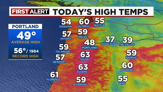
Temperatures have become increasingly mild as well, and anyone outside today surely noticed. Take a look at the high temperatures across the Pacific Northwest for Saturday.

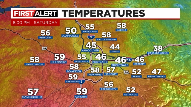
Next take a look at the local effect the Columbia River Gorge is still having on the Portland area. As of 8pm a “cool” easterly breeze is still keeping PDX, Troutdale, and locations right near the gorge cool while the entire rest of the region is in the upper 50s. Kind of neat to see the effect the gorge has on the area.

Both Sunday and Monday look to be about as nice of days as you can get this time of year in regards to both temperature and lack of precip. Sunday will feature a chance for a couple isolated showers, but for the most part ample sunbreaks SHOULD rule the day. Highs Sunday will likely top out in the mid to upper 60s! :) Monday will be similar, but slightly cooler with highs closer to 60 degrees which is still plenty warm for the end of January. By the way, our warmest January temperature ever recorded was 68° in 1899. Will we break that record? Time will tell, but it will definitely be mild. 

Enjoy it, after all it is still winter, and we know for certain cooler and wetter weather will return with time. In fact we know that time will be later this upcoming week lol… :) Tuesday might have a shower or two with highs in the mid to upper 50s, but the rain returns in full force Wednesday. By Thursday cooler temperatures will also return accompanied by mountain snowfall. 

The Cascades

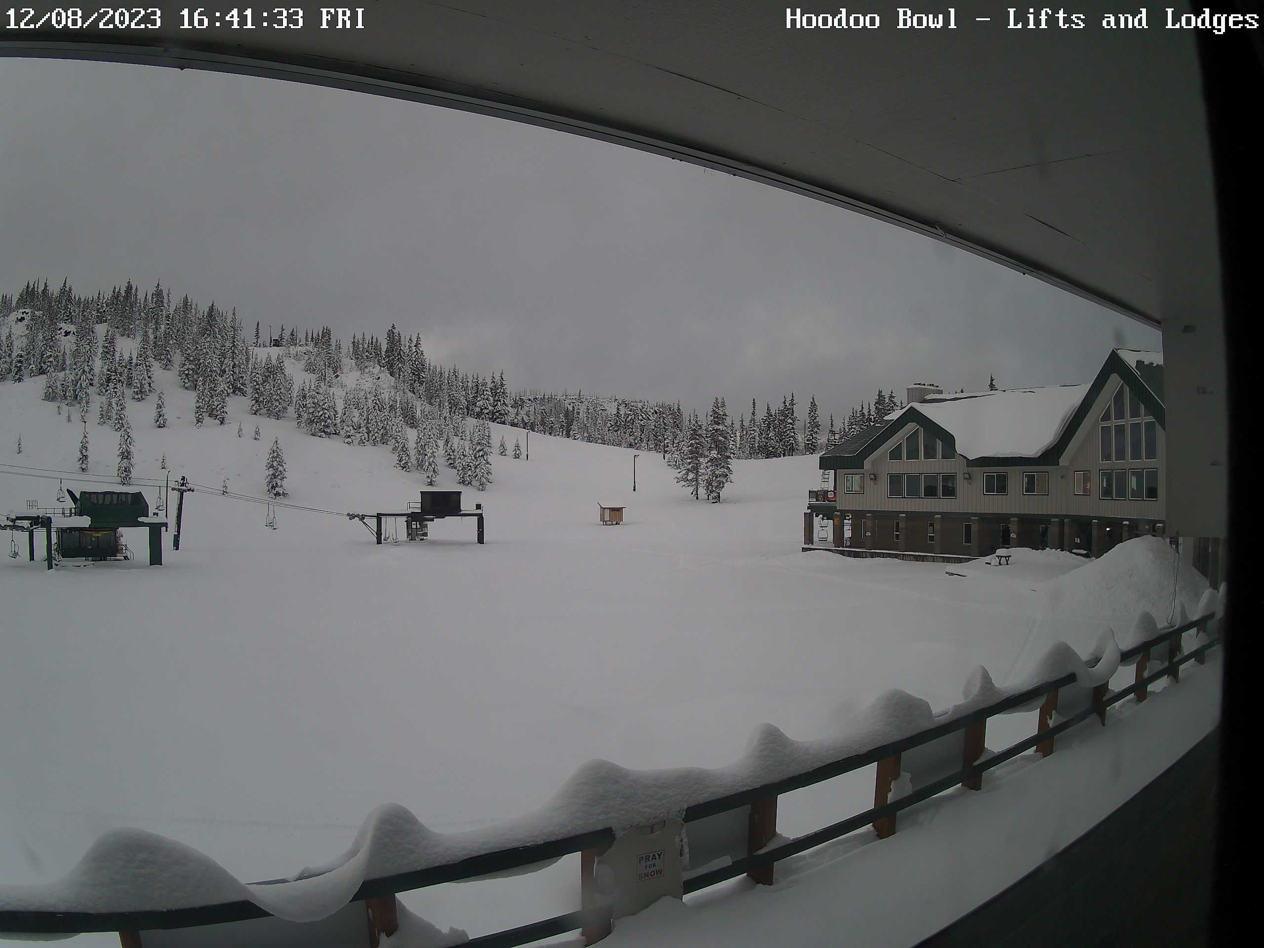
Terrible skiing weather through Wednesday, but all signals indicate a return to much cooler weather along with fresh mountain snow and low snow levels Thursday through next weekend. So hang in there because good skiing weather will return shortly!

I hope you all can make the most of the nice weather!! :)

Thursday night update

In case you are short on time, here are the most important headlines:

  • The Salem area freezes up late Friday morning or early afternoon at the latest with snow showers turning roads snowy and icy.
  • A major winter storm will effect us Friday night through Saturday night brining widespread snow and freezing rain along with power outages for many. 
  • Very cold (sub freezing) air remains in places through at least Tuesday or Wednesday of next week.

Details

We are closing in on what will be one of the largest winter storms we have seen in years. This storm will likely bring both ice and snow to the Salem area with an intense cold as well, and will continue to effect your life for several days to come.

Friday: This is important!! It is increasingly likely that Salem freezes over during the late morning or early afternoon hours. We will probably see snow showers here in Salem while the bitter cold arctic air begins to move in. Roads could turn snow covered fairly suddenly which will quickly make travel very difficult. Even if we don’t get snow initially, roads will turn icy as the temp drops. Our high temperature Friday will occur in a few hours when we hit midnight. Temperatures will continue to drop from there on out. 

Here’s the forecasted radar for Friday at 2pm showing snow showers around Salem and even points south already:

Check out the progress of the cold air. I have the 3 and 10PM temperature maps from the PNW. You can see the progress of the cold air advancing southwestward toward us with Seattle now under the influence of the arctic airmass.

Friday night through Saturday night:A major winter storm rolls across the entire region. Freezing rain, sleet, and snow will fall between Eugene all the way up to Portland and out along the coast even for locations north of roughly Waldport or Newport. Eugene and Newport up to about Lincoln City and Albany will probably be in the freezing rain zone most of the time. Albany, Salem and Woodburn will probably see a “good” mix of freezing rain, sleet, and snow. That will be a real mess!! North of Woodburn should mostly be snow the whole time. This storm should end during the overnight hours early on Sunday. Temps will hold fairly steady in the lower 20s all day long. That’s right, temperatures 20 to 23 degrees coupled with breezy north winds plus snow and ice falling all day long will make for the coldest day we have seen in years. 

How much snow or ice? This is always tough as the exact depth of the cold air and how much moisture falls ultimately determine this, but here’s my best guess for Salem specifically. I’m thinking 2 to 6 inches of snow and a quarter of an inch to 3 quarters of an inch of freezing rain. In general, the more snow we get the less freezing rain we will receive and vice versa. If we end up getting more snow (like 4 to 6 inches), then we may avoid significant power outages here in Salem. Either way, Salem will be shutting down for a few days as roads will be covered with snow and ice.

This estimated radar image shows the various wintry weather precip types for Saturday at 11am. Blue is snow, and the salmon like color is a mix of snow and ice, and the purple represents freezing rain.

This next image shows estimated ice accumulation. Those purples south of Salem are totals over half an inch. Not good for those areas.

This next image shows total snowfall for the storm. This shows Salem receiving several inches of snow, but a small shift in things could give us either more ice or more snow. Put those maps together and you can see why we have a big frozen mess on the way!

Sunday: Frigid! Highs 27 to 29° Lows Sunday night into Monday morning 13 to 16°.

Monday: Clear skies and sunny and super cold. A high around 30 to 32° and a low temp Monday night around 10 degrees F.

Tuesday: We SLOWLY “warm up to freezing after an absolute frigid start to the day. Highs might even crack freezing this day, but not by much. I’m going with a high of 32°.

Hang on and stay safe!!!!!

Important forecast updates

It’s Sunday evening, and it’s the perfect time to do another update. We have a highly active pattern, and I will continue to update fairly regularly all week long.

Highlights

Monday: Showers. High of 49°. Heavy rain late at night with increasingly strong winds. Winds overnight Monday into early Tuesday will gust 40 to almost 45mph

Tuesday: An extremely stormy day with strong gusty winds continuing through much of the afternoon along with heavy showers and downpours at times. Highs in the mid 40s.

Tue night/Wed morning: Well, this time frame continues to look more and more interesting. A very dynamic low pressure system carrying lots of moisture is set to move directly over Oregon. Locations to the south of the storm will see strong gusty winds again leading to another chance at some power outages. Meanwhile, locations to the north could actually see a brief period of heavy wet snow down to near the valley floor. This would be a short lived event and would not last long, but it would make for an exciting start to Wednesday for those who do end up seeing snow. The exact track of this storm is super important and slight shifts north or south will change the zone where snow does/doesn’t fall, so stay tuned, but this storm has “surprise snowstorm” for someone in the Willamette Valley written all over it.

Wed: Showers with sunbreaks. Locations that do see snow Tue night/early Wed morning should see a bit of melting as temps warm back up to the lower 40s with rain showers.

Thu: More rain showers; however, the atmosphere will be cold enough that anyone could see a little slushy snow during the morning hours. PM showers and sunbreaks. Highs around 40°.

Fri – Mon: Increasing confidence that much colder air will at a minimum brush by the region. This is a bitter lobe of arctic air, so even a quick drive by would send temperatures down quite a bit. Should it get any closer and we would could get even colder. By Tuesday things should be a lot more clear, and I’ll provide another update at that time. Same thing for snow. Currently, it appears our high temps over the weekend will remain at the warmest in the 30s which is much colder than anything we have seen this year. Chances for snow or ice over the weekend also are much higher than usual. So for now, plan on the possibility for snow or ice to disrupt your regularly scheduled events this coming weekend.

The Cascades

Mon: Okay day to travel as periods of light snow fall near the summits of our mountain passes.

Tue: Passes may end up closing this day. Some of the worse weather conditions possible will be present all day long on Tuesday. Winds will be gusting 40 to 50mph and snowfall rates will be nearing 2 inches per hour, and total snowfall for the entire day will exceed 30 inches at the to of the passes.

Wed: Another rough day for mountain travel; although things should lighten up some during the late morning and afternoon hours. Expect 8 to 12 inches of snow this day.

Thu: 10 to 15 inches of new snow with snow levels around 1000′.

Have a great Monday, and stay safe and healthy out there! 🙂

Wild winter weather!

There is a lot going on in the weather world right now, and so much to cover. Phew! I’m both excited and exhausted just thinking about it all, so let’s begin!!

The forecast

The rest of today (Saturday): Showers, downpours, maybe a rumble of thunder, and a few more sunbreaks before night comes.

Sunday: A slightly sunnier version of today’s weather with a few more sunbreaks between showers. Really a not too bad of a day minus the occasional shower or brief downpour. High of 46°

Monday: Periods of light rain. High of 49°

Tuesday: An extremely stormy day with strong winds and heavy rain at times. Winds will gust up to 45mph which is strong enough to bring down a few branches or weak trees. Highs in the mid 40s.

Wednesday: More rain and showers with breezy winds of 20 to 30mph. Overall, a very stormy day and a chilly day too. Highs only around 42 to 45°.

Thursday: Chilly with showers and sunbreaks. Snow levels should stay close to 1000′ which means the higher hills around town could see some slushy snow during the morning hours. Highs 41 – 43°.

Fri – Mon (Jan 12th – 15th): As we stand right now, this entire stretch of days appears to have a pretty high chance for widespread snowfall along with very cold temperatures. Too far out to know specifics, so look for more details in updates to come. Currently, I’m calling for highs in the lower 30s with lows in the teens or 20s. I think most of us see at least 1 to 3 inches of snow at some point during this time frame, and don’t be shocked to see things change further. We will be dealing with a bitterly cold arctic airmass, and depending on how close it gets to us, we could be looking at some significant winter weather in terms of not only snowfall, but extreme cold as well. It could also warm up too… Just stay tuned for more updates in the coming days as a lot can change when we are looking 6 plus days out.

I rely a bit on charts like this one below to help with forecast confidence. The best way to look at this chart is to first notice the dates on the bottom. Time goes from left to right (just like how we read). Next, we have the horizontal lines which also are read from left to right. Each line represents a possible outcome in terms of snowfall for Salem. These are 24 hour running totals. The basic concept you should look for is agreement. The more horizontal lines showing snowfall around the same time frame, the higher the chance is we actually get snow. I’ll try and share an updated edition of this chart in a day or two to help compare and see if things are trending snowier or not so snowy. By the way, ignore the grays for the most part. I usually interpret gray to mean 1000 foot snow levels – so snow maybe in the hills, but not likely in Salem. Look for the blues, purples, and pinks.

The Cascades

As mentioned in the previous post, the Cascades are getting hammered, and will continue to get hammered with feet of snow by the time next week ends.

The Coast and Coast Range

Waves will peak in intensity Tuesday. Maximum wave heights look to be 35 to 45 feet that day along our coastline! Wednesday they should still be going strong coming in above 30 feet. The rest of the week should feature more typical wave heights, but with the “King Tides” later next week, the chance for coastal flooding is certainly higher than normal. Be extra careful if you are out along the beaches next week.

Meanwhile, snow could fall in the Coast Range both Wednesday and Thursday mornings. Travel over the Coast Range should be mostly snow free during the daylight hours though.

So much going on, and a ton of wild wintry potential, so look for more updates regularly as things unfold.

Stay safe, and happy weekend!!

2024 and stormy weather ahead

Happy new year to you all! We have endured a pretty gray and dreary winter so far. Plenty of rainy days, and when it hasn’t been raining, it feels like fog has ruled the day. Very few clear crisp winter days for sure. It’s also been a pretty boring month weatherwise. No big storms, no snow, cold, ice, wind, floods – nothing really, but this is about to change. I’m watching multiple storms which are set to impact us beginning on Saturday and lasting through next week. I’m also watching the potential for much colder weather. Nothing for sure yet, but we will be in the correct type of weather pattern for valley snow if things line up just right. A far cry from the damp and foggy weather we have seen the past 5 weeks.

Highlights

1.)  Thursday will be a damp/gray day. Maybe a few sunbreaks mixed in, but for the most part it will be a cloudy with showers at times.

2.) Friday stands the best shot at being totally dry. Maybe even a few sunbreaks during the afternoon as we sit in between storms. Highs 46 to 50°.

3.) The storm moving in early Saturday morning will have some heavier rain with it along with gusty winds. PM showers, downpours, and sunbreaks. Overall a stormy day.

4.) Sunday will feature showers and sunbreaks with some heavier downpours at times and maybe some hail mixed in with some of the heavier downpours.

5.) Additional showers Monday.

6.) A stronger storm system rolls in Tuesday through Wednesday bringing more rain, downpours, and gusty winds.

7.) The really juicy and wild news is we have the potential to see snow at some point between Thursday and Sunday of next week here in the Willamette Valley and even along the coast. Too far away to know details, but it is clear that much colder air will be dropping in from the north later next week and moisture might come with it. I’m watching things like a hawk, and will of course have more updates as time goes on. 

The Cascades

All these colder storm systems will finally bring some good, heavy snowfall for our mountains, and with the added bonus of no warm rainstorms in sight afterwards to wash it all away. Great news for the snowpack and for snow recreation! :) Hoodoo has a base of 8 inches as of Wednesday night, so let’s see how much more they have by next week….

Fri:Good travel day. Dry passes, and nothing much going on.

Sat: Very snowy with gusty winds. Terrible travel day. 12 to 18 inches of snow above 2000′.

Sun & Mon: Snow showers both days: Not real great travel days, but improved over Saturday. 12 to 16 inches for the two days above 2000′.

Tue & Wed: Heavy snow returns to the mountains along with gusty winds making for two more terrible travel days. An additional 18 to 24 inches of snow up in the Cascades above 2000 feet. Snow levels could drop low enough to impact the Coast Range Wednesday, but still too far out to know for sure.

Thu – Sun (Jan 11th – 14th): A long ways out, but expect a good chance for at least some snow over this time frame as colder air moves in. Excellent skiing conditions for the 3 day weekend!!! 🙂

Stay tuned!!!

Christmas forecast

We’ve had some pretty tame weather lately, and looking ahead, I still don’t see much weather action for us as we head into Christmas. All the riveting and exciting details below. ;)

Fri: Morning rain will transition into a few PM showers. Chilly. Highs in the mid 40s. Mountain snow in the Cascades through Friday night.

Sat: Improving travel conditions in the Cascades with afternoon sun. Highways like Santiam Pass should quickly clear up making for a good travel day. Lows will start out close to freezing, and highs around 45° here in Salem.

Christmas Eve: Another chilly day with lows starting out below freezing, and highs topping out around 42 – 44°. Dry during the day with rain chances increasing around sunset and lasting through the night. There is a chance for some ice in the Columbia River Gorge along highway I-84. Keep an eye on road conditions this day if you have to travel through there. 

Christmas Day: A chance of showers with temps in the 40s.

Next week: No large storm systems for the moment. Currently, it appears this will be a mild week with highs in the 50s and chances for some rain each day. Again, no big storms necessarily here; however, powerful storms off our coast will make for some fun wave watching as maximum wave heights bounce between 25 and 35 feet beginning Christmas Day and lasting through next week.

Enjoy this time of year the best you can, and remember what is really important! Don’t stress over the little worldly things. 

Stay safe! :)

Rainy weather recap

Well we made it through several really rainy days earlier this week, we briefly dried out, and now we are staring down another hefty rainstorm for this weekend. Details in a minute, but first, a quick glance at how we did in terms of total precip during our stretch of rainy weather.

Rainfall was persistent, but rarely was it real heavy, and certainly never for very long which allowed Salem to escape any big flooding issues. There was some flooding of parking lots, a few streets, and a couple parks around town, but nothing significant. In the end it honestly felt like regular rainy Oregon weather, but with a mild touch to it. This past Monday and Tuesday both saw highs in the low 60s here in Salem which is WAY above normal for this time of year!

Flooding was more severe out in the Coast Range and along the coast specifically areas near both Tillamook and Seaside.

A typical 7 day stretch this time of year would give us around 1.65″ of rain, so receiving over 5 inches of rain over the same time frame is definitely on the excessive side of things. However, for you “old timers” (this includes me haha), the major floods of February 1996 gave Salem over 8 inches of rain in only 4 days, so it puts our recent deluge into perspective a little.

Here are three pictures from the flooding this past week. One is of some minor street flooding here in Salem, another is of a flooded house near Garibaldi along the coast, and the other is of a landslide which occurred in Portland.

The forecast

Saturday: A cool and cloudy day with rain much of the day. Temps in the upper 30s to low 40s all day long with rain at times. Chilly and rainy – the best of both worlds… 😉

Sunday: Rainy. Expect a full inch plus of rainfall between Saturday and Sunday. Yes, the rain is returning in full force, and it will be on the heavier side at times.

Mon – Wed: Dry. Fog is likely in some areas, especially locations away from the Columbia River Gorge. If we don’t see fog, then expect beautiful sunny skies, and chilly nights. Highs in the upper 40s and lows around freezing.

Thu: Some rain overnight Wednesday will last into Thursday morning. Dry during the afternoon.

Fri: Dry. Highs in the upper 40s and lows around 30 to 32°.

The Cascades

The Cascades and our local ski resorts are having a rough go of it so far. It’s definitely early in the season still, but the warmer rainstorms we keep on seeing are making it tough to hang onto a good snowpack. Hoodoo went from no snow on the ground on November 29th, to 2 feet of snow on December 2nd, back down to an inch this past Wednesday, and now they are back up to having nearly 20 inches! Phew, what a ride, but wait, there’s more haha!! The rain coming in this weekend is associated with a very warm airmass which means more rain in the mountains. It will be interesting to see how much snow survives this incoming storm. I snagged a cam shot showing how it looked late this afternoon.

That’s all for today. Once we get through the storm this weekend I really don’t see anything overly interesting for awhile. Stay safe, and enjoy the weekend! 🙂