The week ahead

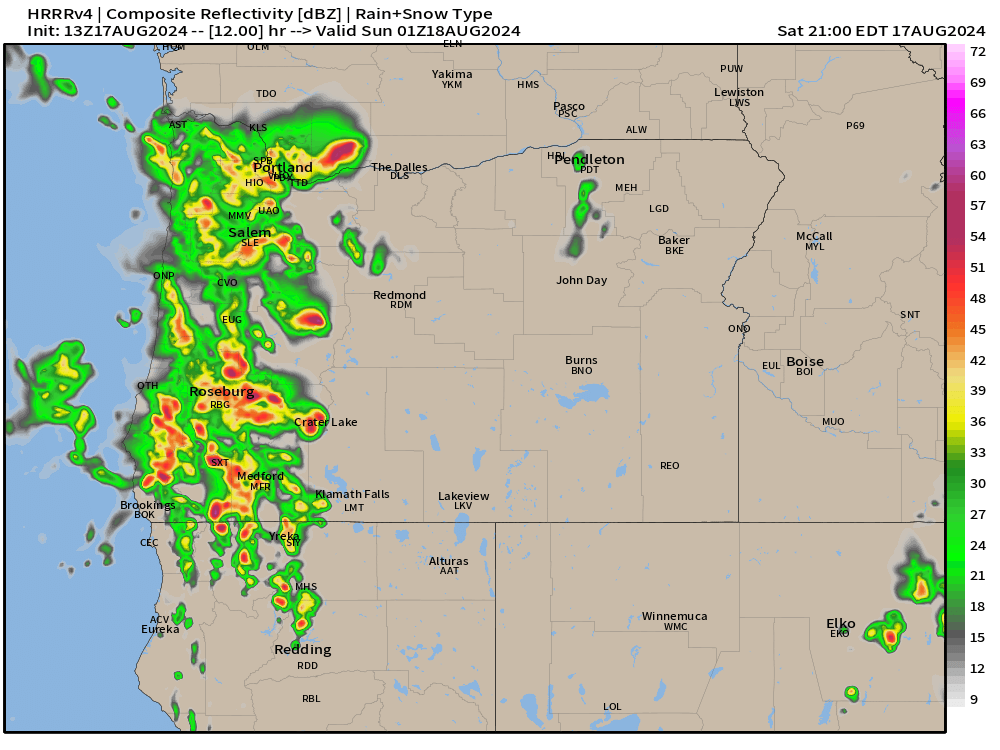
Greetings again! 🙂 A very short update tonight. The brief period of light rain we are seeing this evening will end tonight leaving us dry come Wednesday morning. This is a weak and fast moving storm, and really it’s just brushing us on it’s way to California.

The rest of this week will be nice and dry. In fact, dry weather is likely through next Tuesday or even next Wednesday (the 25th). Patchy fog some mornings, and lots of warm afternoon sunshine. Lows each morning in will begin in the upper 40s to near 50° and highs will soar into the mid to upper 70s. In my opinion it will be near perfect early fall weather.

The other nice thing is the rain has really brought our wildfire season to a crawl. It’s extremely unlikely we will see any new outbreaks of fires this season, and if you look at this map showing total precipitation over the past 30 days then you will see why it’s so unlikely.

The majority of the Cascades have picked up 2 to 3 inches of rain over the past few weeks with more falling this evening. The fires will certainly continue to burn, but at an incredibly slow rate. Their days are numbered.

Knowing we can enjoy the sunny weather and not fret over new fires is really nice. So take advantage of the beautiful warm afternoons and nice crisp mornings while it lasts, because we all know the rain will return again.

Have a great Wednesday and stay safe!!

Wild weather part two

Well, last night’s post is already off track a little. Thunderstorms and showers are already rolling up the valley. Clearly, the very unstable atmosphere is doing its thing.

This does NOT change the forecast for later. Stronger storms are still expected to hit later this afternoon and last through the evening. I’ve basically copied and pasted the update I did last night down below. Just wanted to acknowledge that we are having storms earlier than predicted, and that the bigger and more widespread storms are still on track for later today. Updates different from last night’s post are highlighted in green.

At some point between 2pm and 5pm powerful storms will roll up the valley from the south/southeast. Storms could last well through the evening with some weather models hinting at a second round of storms sometime shortly after sunset. Impacts will include gusty winds above 40mph in some locations, heavy rain, localized flooding, and numerous lightning strikes. Hail could be present in these storms too. This is about as close as we can get to a mid west type of storm. Here’s an updated estimated radar image for 6pm today showing more widespread storms rolling through the valley.

By Sunday morning we will see a return to calmer weather. It will be cooler with more clouds at times with a slight chance of a shower, but no thunderstorms or anything wild.

Mon – Sat: Much of this coming week will be dry, but clouds will be more frequent and highs will generally stay in the upper 70s to near 80°. Additionally, there will be a slight chance for showers almost each day. The majority of this coming week will be dry, but the risk for a shower will be present. Best chance for more significant rain will be Thursday and Friday.

Stay safe!

Wild weather

The weather is about to take a turn to the wild and even dangerous side if you will. This will be a quick post, but the threat for intense and possibly even severe thunderstorms here in the Willamette Valley warrants a post.

Details

Saturday will start off like a usual summer day with plenty of sunshine and warm temps. Temperatures should climb into the lower 80s. An upper level low spinning off of our southwestern coast will put into play all the ingredients necessary for strong thunderstorms to form: high moisture content, warm temps, and strong forcing throughout the atmosphere.

At some point between 2pm and 5pm powerful storms will roll up the valley from the south/southeast. Storms could last well through the evening with some weather models hinting at a second round of storms sometime shortly after sunset. Impacts will include gusty winds above 40mph in some locations, heavy rain, localized flooding, and numerous lightning strikes. Hail could be present in these storms too. This is about as close as we can get to a mid west type of storm. Below is the estimated radar for 5pm. Don’t get caught up looking at the exact locations of the storms in this image, but take in the big picture here which is showing very strong storms throughout the Willamette Valley and Cascades Saturday afternoon and evening.

By Sunday morning we will see a return to calmer weather. It will be cooler with more clouds at times with a slight chance of a shower, but no thunderstorms or anything wild.

Mon – Sat: Much of this coming week will be dry, but clouds will be more frequent and highs will generally stay in the upper 70s to near 80°. Additionally, there will be a slight chance for showers almost each day. No all day washouts, and the majority of this coming week will be dry, but the risk for a shower will be present.

Take care, and stay safe Saturday with the storms out there!

Much more comfortable

After 13 days straight of 90 plus degree weather (which is the 2nd longest stretch in recorded history), we finally have a much more comfortable summer weather on the way with one exception.

Details

Thu & Fri: Some morning clouds. with cool temps each morning. Lows both days will start out around 55° and highs will be close to 90 degrees.

Sat: This is the one exception to our more comfortable weather. Highs will once again soar into the upper 90s which is a little too hot in my opinion.

Sun: There is a chance for showers and possibly thunderstorms again on Sunday. I’m watching this day closely as there is still a lot of disagreement regarding the track of the storm. Rain or no rain, highs Sunday should end up in the low to mid 80s.

Mon – Wed: Highs in the mid 80s and lows between 53 and 56°. Very nice summer weather.

That’s all for now. Last night’s brief thunderstorm excitement put on quite the show for some of you. East valley locations like Sweet Home, Molalla, and Scio all had a good lightning display. Corvallis on the west side of the valley had a notable thunderstorm roll through as well. Unfortunately, the storms also ignited dozens of new wildfires. Hopefully the impact from these new fires can be minimal.

Rainy and cold weekend

We have a full on washout occurring right now, and the chilly rain continues basically through the entire weekend with only brief breaks Saturday afternoon (maybe), and some breaks in the rain at times on Sunday. Roughly an inch and a half of rain will fall between now and Sunday night. Highs Saturday in the upper 40s to near 50°, and Sunday won’t be much better with highs around 54°.

Monday: Heavy showers with a few sunbreaks. High of 54°.

Tuesday: Showers and sunbreaks but with more sunbreaks than Monday. High of 58°.

Slight chance for a thundershower both Mon and Tue.

Wednesday: The showers end Tuesday night, and partly cloudy skies will lead to highs in the low 60s.

Thursday: Things start warning up with highs in the low 70s.

Fri – Sun: This might seem crazy, but each of these three days should end up with high temperatures around 80°. This means plan on a great three days of weather for outdoor activities next weekend.

The Cascades

It’s almost that time of year where we don’t have to worry about mountain snowfall affecting travel, but we are not there quite yet haha! Expect 12 to 18 inches of new snow up in the Cascades tonight through Sunday evening. Several more additional inches will fall Monday, and then again on Tuesday a few more inches of snow before things calm down up there.

That’s all for now. Thanks for sticking with me as your weather guy even though posts have been sporadic lately.

I hope you all have a good and safe weekend making the most of the rain. Remember, it might seem like too much rain, but it is the rain which makes things so beautiful here. 🙂

The usual

Winter almost always makes a usual “come back” in February, and it appears this winter will be no different. We have an active week ahead, so let’s jump into the details!

Details

Mon: Showers and sunbreaks. Downpours of rain, hail, graupel, and maybe even some sloppy wet snowflakes are all possible Monday along with a rumble of thunder or two. It will be an exciting day for sure!

Mon night – Tue: Leftover showers Monday night could bring a dusting of snow to anyone. Keep in mind the odds are very low, but do increase the higher up in elevation you are. Tuesday will be fairly gray with light rain at times and chilly with highs in the lower 40s.

Wed: Rainy and windy. Winds will likely gust 30 to up to 40mph.

Wed night – Thu: I’m watching this time frame for the potential for lower elevation snow as heavy rain stalls over the region along with cooling temperatures, and light or even calm winds. If things work out right, someone in the Willamette Valley could end up with a few inches of heavy wet snow early Thursday morning. Check for updates this week as time draws closer. For now plan on a cold rain.

Friday – Sunday: Chilly with low snow levels continuing. Showers and sunbreaks by day, and chances for some wet slushy snow at night. Any given location could pick up some snow; however, the best opportunities favor locations with some elevation.

Cascades

The map below tells the whole story. We have feet of snow coming up beginning right now and lasting all week long. Expect snowy weather when crossing the Cascades every day this week.

This map shows upwards of 5 plus feet of new snow in the Cascades now through next Sunday!!

Coast Range

Snow will effect the Coast Range quite a bit especially Monday and then again Thursday through Sunday. These passes won’t be nearly as bad as the Cascades; however, you still need to be prepared for a few inches of snow up there each of those days. Referencing the map above, I see roughly 1 to 2 feet of snow in the Coast Range this coming week.

Recap

Currently there are no slam dunks for valley snow, but we will have multiple shots at seeing wet slushy snow – especially if things line up just right. So as mentioned, keep an eye for updates as it will be a “fun” (my opinion) and wild week of weather!

Stay safe out there. 🙂

February

January was a wild month, but things have calmed down lately. We have seen some really nice days with the tail end of January being especially mild. Salem set a new record high of 66° for the date of January 28th missing the all time January record of 68°. Today turned out to be a fantastic day as well. It honestly felt like March rather than the beginning of February. 

Sunday is looking nice, but not quite as amazing as today was due to two reasons: 1.) Gusty winds of 20 to 30mph develop as the day goes on which will provide an extra chill to the air. 2.) Clouds will be slowly moving in all day long with rain arriving by dinner time (5 to 7pm).

Here’s the next several days with details below.

Monday: Drippy and gray with periods of rain throughout the day.

Tuesday: Sunbreaks with a few showers or downpours possible.

Wed & Thu: Both these days will likely be on the showery and cooler side. Downpours of rain and even some hail likely both these days. 

Friday: Slight chance for showers as we stay in a cooler pattern.

The Cascades

Snow levels will remain at or below pass levels Monday through Friday. Not a lot of snow, but anywhere from 2 to 6 inches each day should add up helping out the snowpack a little and making for some nice skiing weather really all week long and into next weekend too. Snow levels will be at their lowest Wednesday and Thursday. Perhaps down to 1500′.

Have a great rest of your weekend!