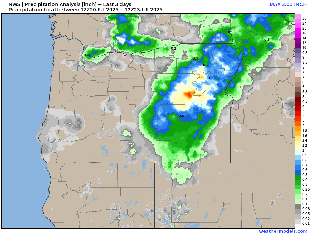
Rain in July is very rare, light, and often times scattered in nature. The showers we saw Sunday and early Monday morning were no different with the Portland metro area being the big winner as you can see from this rainfall chart below.
Some fairly hefty downpours across parts of eastern Oregon in addition to the Portland area seeing rain. Much of the coastline and the central and southern Willamette Valley remained mostly dry, but now it’s back to regular summertime weather.
Forecast highlights
The next several days should be rather pleasant with highs ranging from the low 80s to low 90s through this coming Tuesday. A very typical summertime forecast with varying amounts of low clouds during the morning hours, lots of afternoon sunshine, and dry.
Cool nights stick around. I don’t see any morning lows warmer than 60° on the horizon, and in fact, lows should make it down to the lower 50s most evenings. I’ve been thoroughly enjoying the fresh air and cool evenings, so I’m happy to see that continue!
Saturday and Sunday in particular both look cloudier and cooler, but dry. Highs upper 70s to low 80s.
Watching for a shower/thunderstorm chance next Wednesday and Thursday. Despite being several days out, the chance is high enough to be mentioned. I’ll keep an eye on that threat and will do my best to update you as time gets closer.
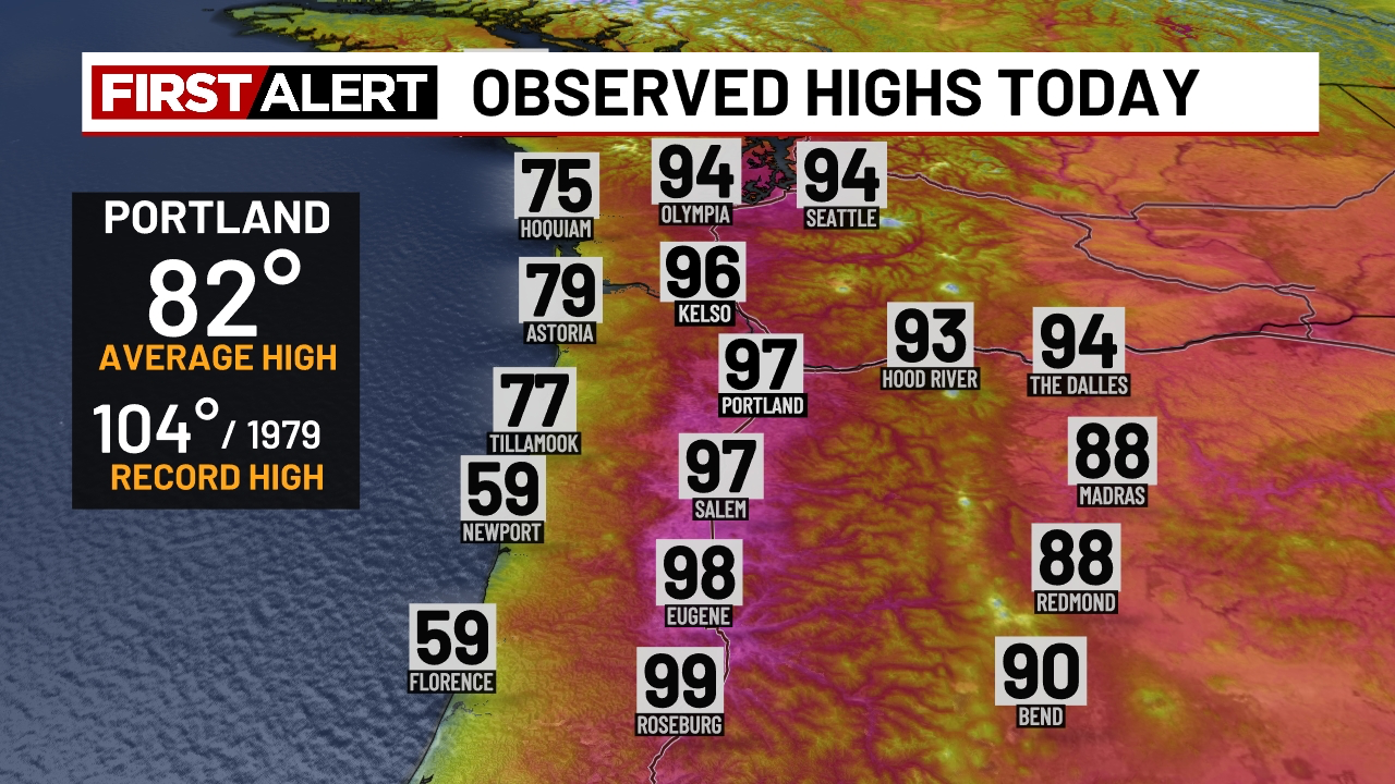
We had a scorcher today! Highs ended up in the upper 90s up and down the I-5 corridor this afternoon.
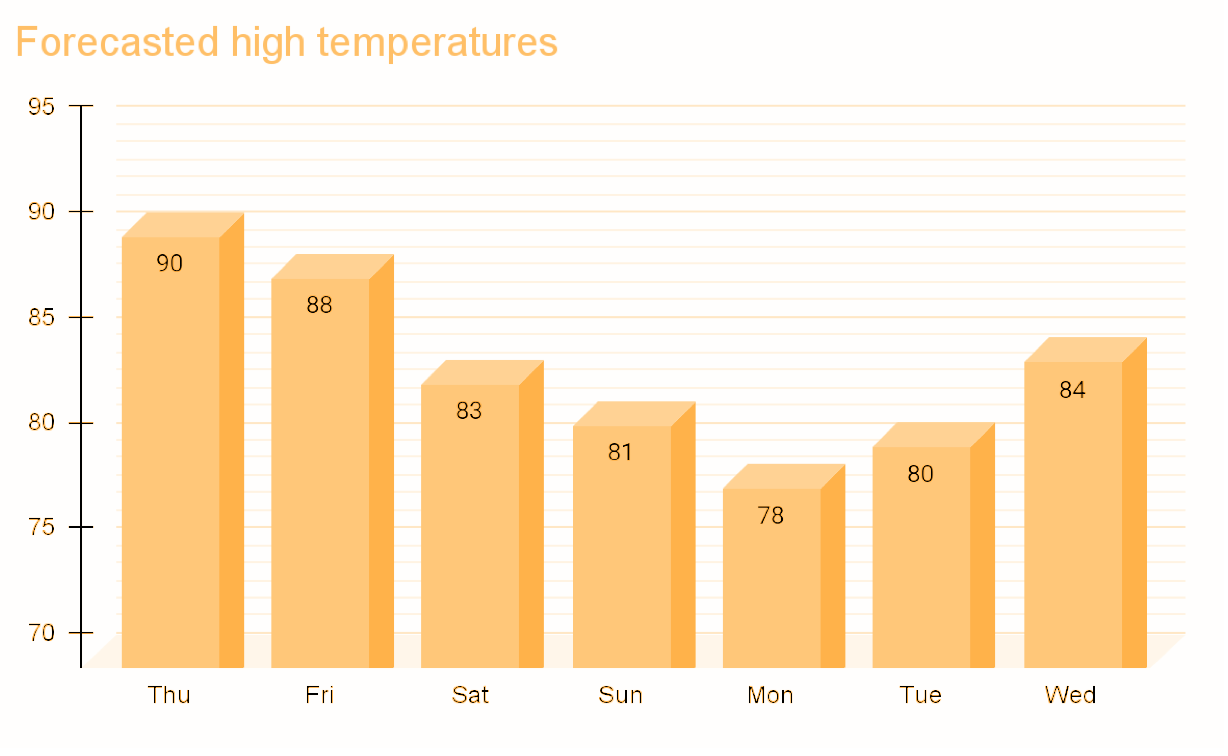
For the next several days, our temperatures slowly and steadily drop each day until we find ourselves down to the upper 70s by Monday. The cooldown will be gradual. Right now I’m thinking it goes something like this:
Relief from the heat comes slowly late tonight with temperatures expected to cool off to around 58° come early Thursday morning. Temperatures cool off much quicker in the evenings to follow with lows ranging between 52 to 57° through next Wednesday. Plenty of cool fresh air each night beginning Thursday evening! 🙂
Lastly, we could even see a few showers Monday for areas west of the Cascades. Would certainly feel refreshing, and it would help keep the fire risk down at least temporarily.
Looking out beyond next Wednesday, it appears our usual summertime weather will continue to dominate the region. This means dry/mostly dry weather, lots of sunshine, and highs primarily in the 80s to low 90s.
We are entering the middle of July now and our regular summertime pattern has taken hold of the region. Highs the past several days have ranged from 80 to 93° with no rainfall and no rain in sight. Highs will bounce around between the mid 80s to upper 90s over the next 10 days making for a hot stretch of summer weather. At this time, Sunday and Wednesday look to be the hottest days this coming week with highs reaching the mid and upper 90s. Monday is the only day this coming week that might be close to average with highs in the mid 80s (I’m going with 87°). Still a hot day, but more comfortable than those mid 90s. Lows Tuesday morning will dip back into the upper 50s providing a brief respite from the heat.
Details
Sat: Morning low of 62° and daytime high of 91°.
Sun: 64°/94°.
Mon: 64°/87°.
Tue: 57°/91°.
Wed: Hot! 64°/97°.
Thu: 64°/91°.
Fri: 59°/88°.
Afternoon and evening breezes look to be pretty regular over the next several days. The breezes should help take the edge off the heat just a little making it feel slightly more comfortable.
Next weekend: Still looking hot with more 90s likely. The next six weeks are historically very dry and warm around here, and rain during this timeframe is rare. I’ll keep my eye out for any chances at rain, any thunderstorm chances, or anything else real unusual or impactful. Stay cool and stay safe out there!
Sunday through Tuesday: Very warm. Highs 90 to 92°.
Wednesday: More reasonable with mostly skies and highs around 83°.
Thursday through Sunday: Highs in the upper 70s to low 80s with cool mornings starting out in the lower 50s each day and more cloud cover, especially during the morning hours.
Details
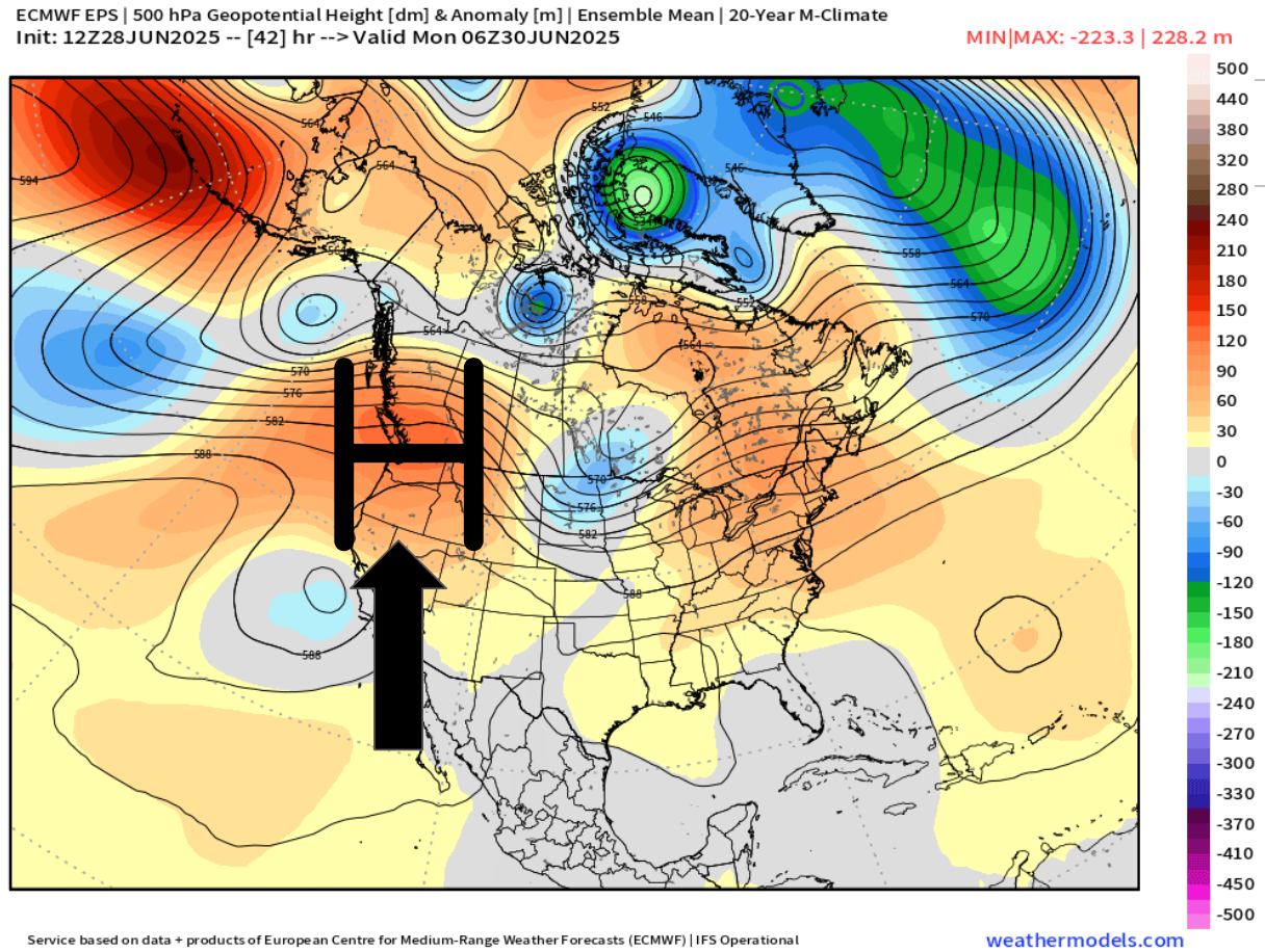
For the next three days we will be under the influence of a high pressure bringing us very warm weather. The map below shows this very nicely with the warm airmass centered directly above Oregon Sunday night.
The second half of the week will be dominated by marine onshore flow. This next map illustrates this well showing the high pressure being pushed to the east allowing cooler air from the ocean to move inland early Thursday morning.
Overall, it’s looking mostly dry the next 7 days with some minor exceptions, and depending on your travel plans, these exceptions could effect you.
Exception #1. A few thunderstorms and showers are likely in the Cascades and in central Oregon Monday through Wednesday.
Exception #2. Drizzle and a few sprinkles are possible along portions of the coast specifically Thursday through Sunday. During those four days the onshore flow is stronger which will bring in marine air. During summertime, these setups can produce very light (and spotty) precipitation along the coast and even in parts of the Coast Range.
So, after a few very warm days to begin the week, we return to the stronger onshore flow which will return temperatures back to normal or even slightly below normal just in time for the 4th of July weekend. Much more comfortable than the scorcher we saw last Independence Day. 🙂
Wed – Fri: Cooler with lots of clouds and chances for sprinkles/light showers.
Sat – Mon: Warmer again with mostly sunny skies.
Wet weather recap
The rainy weather did not disappoint. In fact, Friday and Saturday were the rainiest back to back days since the first week of April! The map below shows rainfall totals from the weekend.
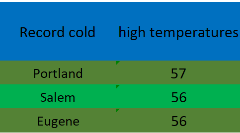
A solid half inch to inch in the valley and over an inch to two inches up in the foothills and mountains. The low pressure and steady rain was accompanied by chilly temperatures too. Record low high temperatures were set on Saturday all over the valley.
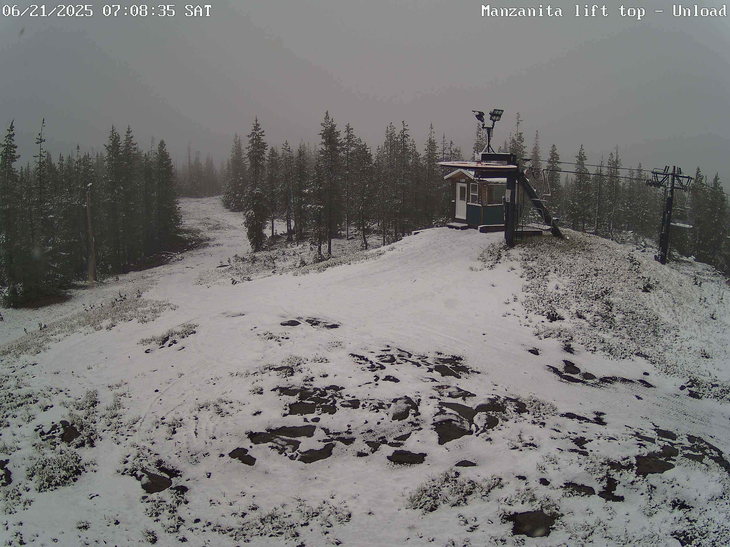
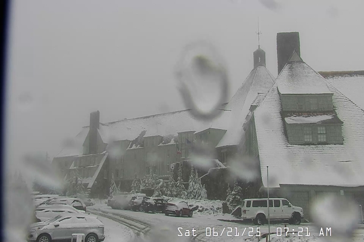
Snowfall also made it’s way to the Oregon Cascades. These two images show snowfall on Hoodoo and up at Timberline Saturday morning. Fun to see snow falling up there on the first full day of summer!
Forecast details
Tue: Very similar to the weather we saw today. Highs in the low 80s.
Wed – Fri: Each day will feature a very slight chance of drizzle or a few light sprinkles. Nothing widespread or heavy. Lots of cloud cover with sun breaks mixed in at times. Highs in the low 70s and early morning lows 53 – 55°. Best chance for any light showers or sprinkles looks to be Wednesday and Thursday with a lower chance on Friday.
Sat: Sunshine returns with highs in the lower 80s and mostly sunny skies. A real nice day after a refreshing start that morning with lows in the low 50s.
Sun & Mon: Sunny and warm with highs in the mid to upper 80s.
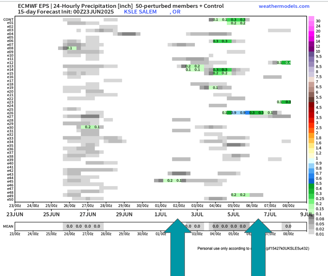
Looking further out to the first week of July it still appears we could have another shot at a few showers. Too far out to say with certainty, but there are enough individual members (horizontal lines) calling for rain at some point during the first week of July that it has my attention.
The biggest take away I see is that there is no sign of hot weather the next two weeks. Some upper 80s, but nothing prolong or real significant. I’ll keep an eye on that 4th of July forecast, but in the meantime enjoy the nice weather.
It’s been a long time since I posted. The weather has generally been extremely uneventful, plus I’ve been busier than usual with work and side projects (including the garden). Regardless, I figured it was time for an update.
The forecast
Wed & Thu: Onshore flow increases pushing in a stronger marine layer along with a very weak front. This will result in highs in the low to mid 70s. Expect plentiful AM clouds with PM sun breaks. We could see a sprinkle Wednesday morning; otherwise, these two days will remain dry.
Fri: PM showers. A cold atmosphere up above will result in the possibility of thundershowers too. Some of the downpours could be quite heavy. Highs right around 60°.
Sat: Additional showers and thundershowers with a more steady rain likely during the late afternoon and evening hours. This will produce a widespread soaking rain for areas west of the Cascades. Downpours will have potential to be heavy. Highs will struggle to reach 60°
Sun: Showers wrap up with much of the day being dry. Just keep in mind that showers could still take place during the day on Sunday. Highs into the lower 70s again.
Mon – Wed: Partly cloudy to mostly sunny skies. Highs around 80° each day. Lows will start out chilly right around 50 to 53°.
Rain totals look to range from half an inch to just over an inch of rain here in the Willamette Valley. This will bring much needed precipitation to our region!
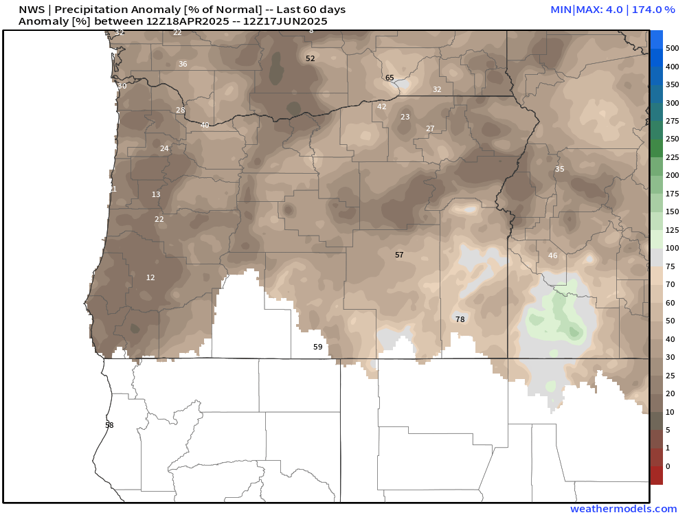
Aside from the first week of April, we have been unusually dry this spring. The few “rainy” days we have seen the past 8 weeks have not produced more than a third of an inch on any given day. The map below shows percent of normal precipitation locations have picked up between April 18th and June 17th. Many valley locations are running at a mere 15 to 25% of average.
We are running slightly better precipitation wise than the dry and hot spring of 2021. That year brought our most intense heatwave ever with temperatures soaring above 110° throughout the Willamette Valley. That was an awful experience. Luckily, no signs of hot weather.
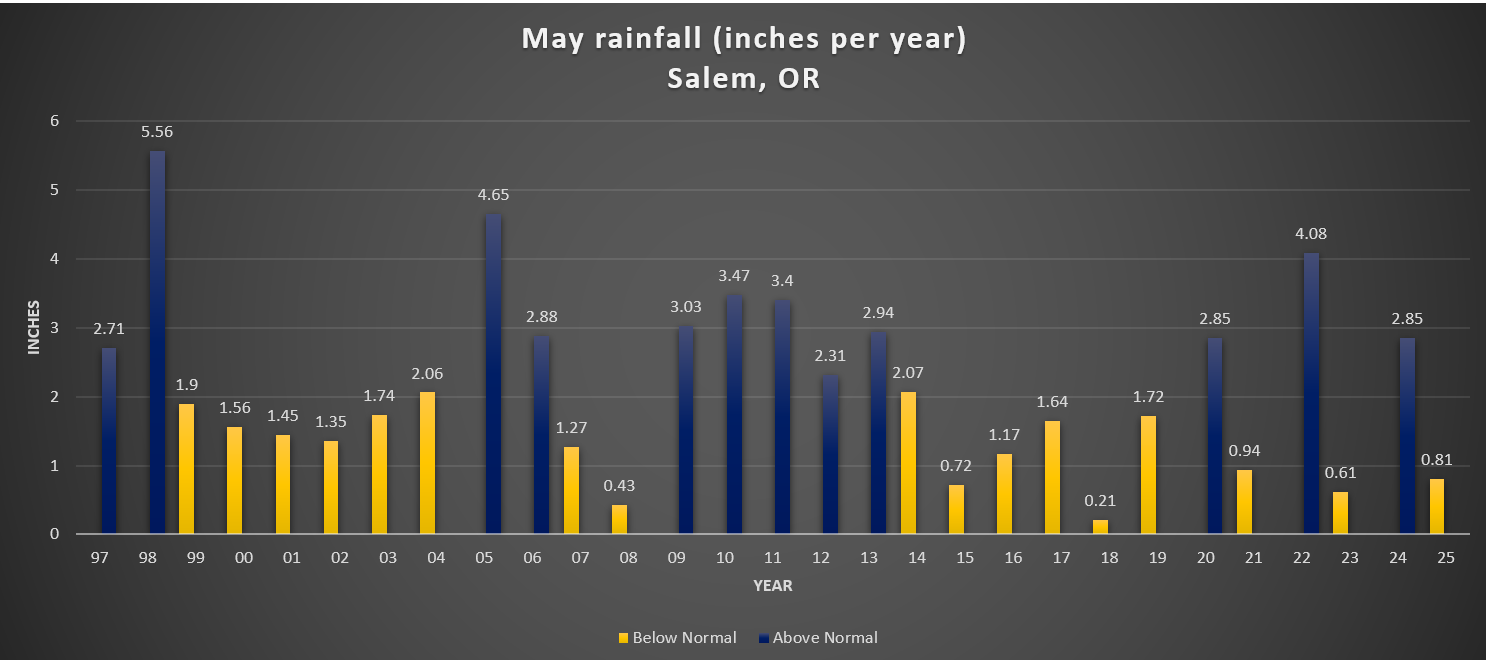
As far as temperature goes, May 2025 went down in the history books as only being 0.2° above normal. For all practical purposes that’s considered average. At the moment, June is running 3.5 degrees above normal, a special thanks to the hot spell last weekend. That number will fall dramatically by this time next week due to the much cooler weather moving in.
For reference, I added a chart showing total rainfall for Salem during the month of May going back to 1997.
There is no clear trend here. The only notable thing I could see was the tendency for totals to range more drastically over the past several years, but in the grand scheme of things, several years is hardly a trend.
We’ll see where we end up for rainfall in June. For now enjoy the continued dry weather, and keep in mind that Friday through Sunday will be generally wet.
The Cascades
Planning on hiking or camping up high? Well, plan on some snowfall Friday night through Saturday night. Snow levels will dip down low enough for the volcano summits/peaks to pick up several inches of snow. Timberline, the tops of the sisters, Jefferson Park, Crater Lake, and any other peaks above roughly 5500 feet could see snow this weekend. Keep this in mind. Spots along the PCT (Pacific Crest Trail) could also see snowfall impacting hikers and backpackers this weekend. By Sunday afternoon the summer sun returns and the snow up there will quickly begin melting off again.
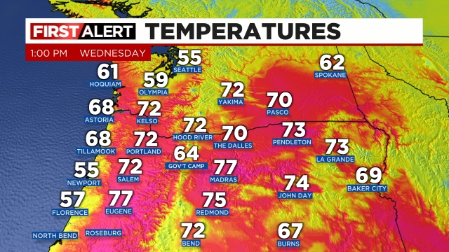
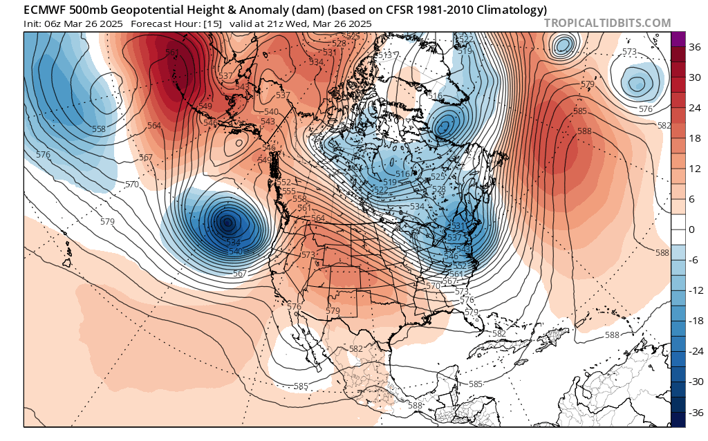
Enjoy, but don’t bee fooled by the beautiful and warm sunny weather. Thunderstorms will become quite numerous at some point later this afternoon through the evening hours. Current temps across the region show the very warm atmosphere which is a prime ingredient for storms in this type of setup.
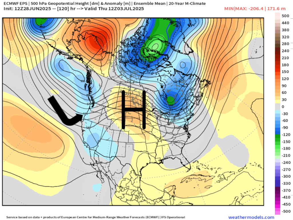
Lots of 70s out there and temperatures are still climbing. Meanwhile, 18,000 feet above us, a “bowling ball” of cold air, strong winds, and precipitation is heading towards us from the southwest. You can see it represented fairly well on this chart below:
The satellite image from early this afternoon shows this well with Salem (where the red arrow is pointing to) is firmly in the sunny and warm sector ahead of the cold front which is moving up as indicated by the blue arrow.
The cold front sweeps northeast later this afternoon and evening sparking numerous thunderstorms and downpours along it. Some of the storms could be severe which is extremely rare for our area. Large hail, damaging wind gusts of 55mph or higher, heavy rain, and dangerous lightning are all possible with the storms. Not every location will see such strong or severe storms, but everyone will see at least a period of very gusty winds (40mph or higher, and some intense downpours as the front moves through and temperatures drop nearly 20 degrees this evening!! Truly some wild and possibly dangerous weather for some of us between now and 8pm tonight.
The main message is be prepared for conditions to go downhill quickly when these storms do fire up and make their way up the valley, and don’t let the calm weather now fool you. Power outages, ponding of water, and downed trees are expected in at least some areas later today with the stronger storms.
Rainy and at times windy weather will continue on and off through Friday before we dry back out for the weekend.