A few showers possible

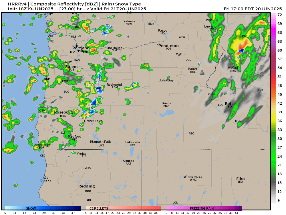
A very short post today. We have a typical thunderstorm pattern for summertime here. Southerly/southeasterly flow aloft is bringing monsoonal moisture to the region. This flow favors thunderstorms to develop over the Cascades, central, and eastern Oregon; however, it can lead to some isolated storms or leftover showers to drift NW over the valley.

In fact, the clouds we saw this morning are a result of the same scenario. The difference is that moisture and instability increase tonight and Thursday. This means showers could drift over the Willamette Valley at any point tonight through Thursday. Nothing long lasting or widespread. Just know that a brief disruption to our regular dry summer weather will be taking place and showers are possible.

Dry summertime weather returns on Friday.

Take care and stay safe!

Typical summer weather

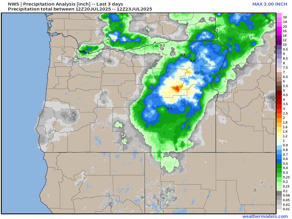
Rain in July is very rare, light, and often times scattered in nature. The showers we saw Sunday and early Monday morning were no different with the Portland metro area being the big winner as you can see from this rainfall chart below.

Some fairly hefty downpours across parts of eastern Oregon in addition to the Portland area seeing rain. Much of the coastline and the central and southern Willamette Valley remained mostly dry, but now it’s back to regular summertime weather.

Forecast highlights

  • The next several days should be rather pleasant with highs ranging from the low 80s to low 90s through this coming Tuesday. A very typical summertime forecast with varying amounts of low clouds during the morning hours, lots of afternoon sunshine, and dry.
  • Cool nights stick around. I don’t see any morning lows warmer than 60° on the horizon, and in fact, lows should make it down to the lower 50s most evenings. I’ve been thoroughly enjoying the fresh air and cool evenings, so I’m happy to see that continue!
  • Saturday and Sunday in particular both look cloudier and cooler, but dry. Highs upper 70s to low 80s.
  • Watching for a shower/thunderstorm chance next Wednesday and Thursday. Despite being several days out, the chance is high enough to be mentioned. I’ll keep an eye on that threat and will do my best to update you as time gets closer.

Take care and stay safe out there!

A nice cool down on the way

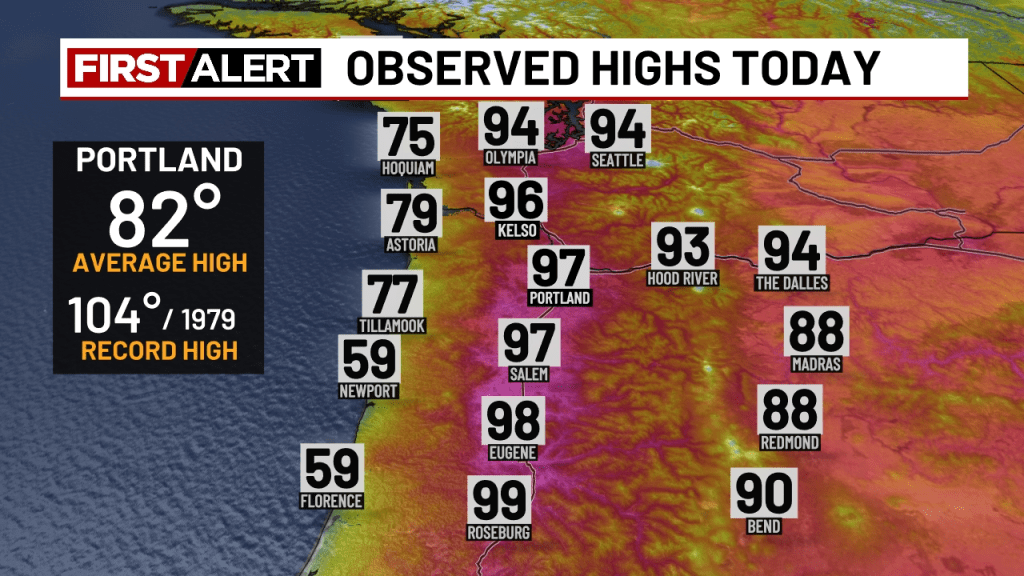
We had a scorcher today! Highs ended up in the upper 90s up and down the I-5 corridor this afternoon.

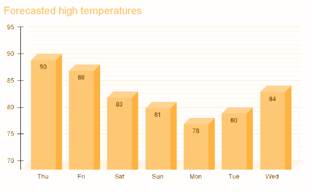
For the next several days, our temperatures slowly and steadily drop each day until we find ourselves down to the upper 70s by Monday. The cooldown will be gradual. Right now I’m thinking it goes something like this:

Relief from the heat comes slowly late tonight with temperatures expected to cool off to around 58° come early Thursday morning. Temperatures cool off much quicker in the evenings to follow with lows ranging between 52 to 57° through next Wednesday. Plenty of cool fresh air each night beginning Thursday evening! 🙂

Lastly, we could even see a few showers Monday for areas west of the Cascades. Would certainly feel refreshing, and it would help keep the fire risk down at least temporarily.

Looking out beyond next Wednesday, it appears our usual summertime weather will continue to dominate the region. This means dry/mostly dry weather, lots of sunshine, and highs primarily in the 80s to low 90s.

Take care, and stay safe out there!

Hot summer weather

We are entering the middle of July now and our regular summertime pattern has taken hold of the region. Highs the past several days have ranged from 80 to 93° with no rainfall and no rain in sight. Highs will bounce around between the mid 80s to upper 90s over the next 10 days making for a hot stretch of summer weather. At this time, Sunday and Wednesday look to be the hottest days this coming week with highs reaching the mid and upper 90s. Monday is the only day this coming week that might be close to average with highs in the mid 80s (I’m going with 87°). Still a hot day, but more comfortable than those mid 90s. Lows Tuesday morning will dip back into the upper 50s providing a brief respite from the heat.

Details

Sat: Morning low of 62° and daytime high of 91°.

Sun: 64°/94°.

Mon: 64°/87°.

Tue: 57°/91°.

Wed: Hot! 64°/97°.

Thu: 64°/91°.

Fri: 59°/88°.

Afternoon and evening breezes look to be pretty regular over the next several days. The breezes should help take the edge off the heat just a little making it feel slightly more comfortable.

Next weekend: Still looking hot with more 90s likely. The next six weeks are historically very dry and warm around here, and rain during this timeframe is rare. I’ll keep my eye out for any chances at rain, any thunderstorm chances, or anything else real unusual or impactful. Stay cool and stay safe out there!

A dry 4th of July

Time for a quick Independence Day forecast.

The quick version

Sunday through Tuesday: Very warm. Highs 90 to 92°.

Wednesday: More reasonable with mostly skies and highs around 83°.

Thursday through Sunday: Highs in the upper 70s to low 80s with cool mornings starting out in the lower 50s each day and more cloud cover, especially during the morning hours.

Details

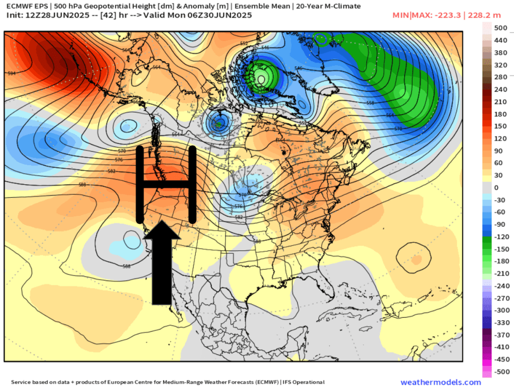
For the next three days we will be under the influence of a high pressure bringing us very warm weather. The map below shows this very nicely with the warm airmass centered directly above Oregon Sunday night.

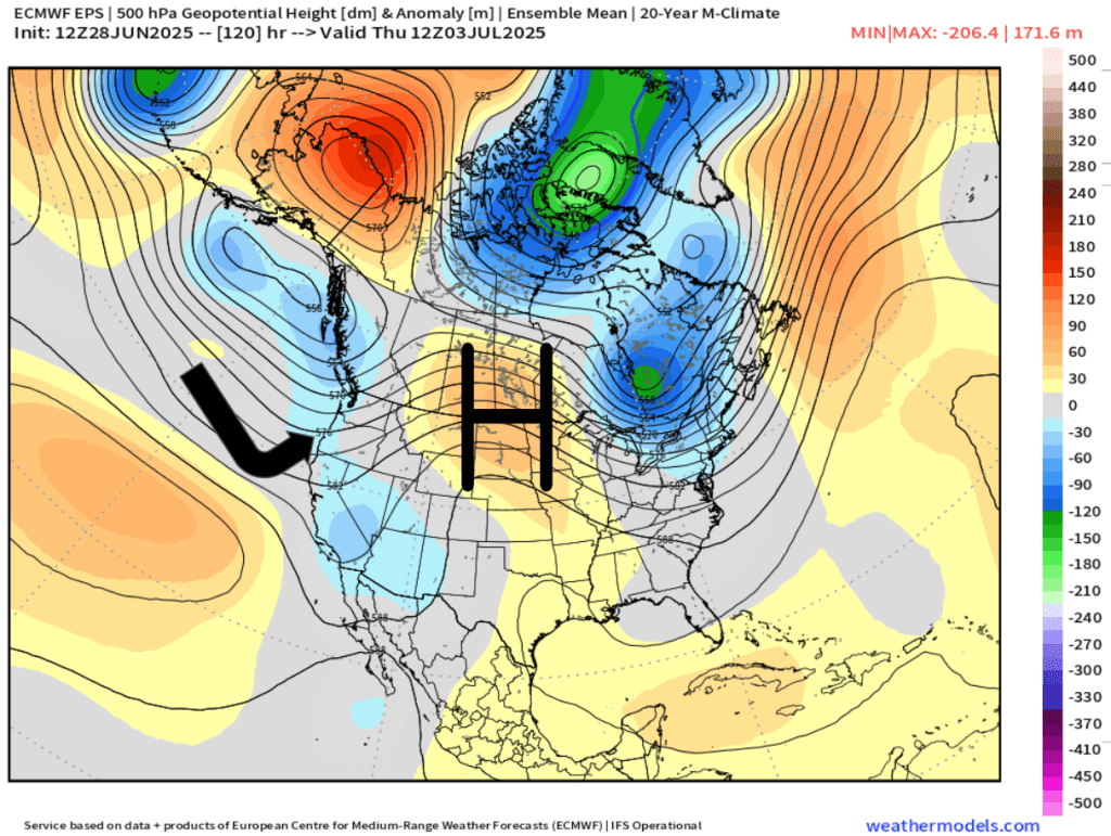
The second half of the week will be dominated by marine onshore flow. This next map illustrates this well showing the high pressure being pushed to the east allowing cooler air from the ocean to move inland early Thursday morning.

Overall, it’s looking mostly dry the next 7 days with some minor exceptions, and depending on your travel plans, these exceptions could effect you.

Exception #1. A few thunderstorms and showers are likely in the Cascades and in central Oregon Monday through Wednesday.

Exception #2. Drizzle and a few sprinkles are possible along portions of the coast specifically Thursday through Sunday. During those four days the onshore flow is stronger which will bring in marine air. During summertime, these setups can produce very light (and spotty) precipitation along the coast and even in parts of the Coast Range.

So, after a few very warm days to begin the week, we return to the stronger onshore flow which will return temperatures back to normal or even slightly below normal just in time for the 4th of July weekend. Much more comfortable than the scorcher we saw last Independence Day. 🙂

A nice week ahead

Highlights

Tue: Warm and dry with mostly sunny skies.

Wed – Fri: Cooler with lots of clouds and chances for sprinkles/light showers.

Sat – Mon: Warmer again with mostly sunny skies.

Wet weather recap

The rainy weather did not disappoint. In fact, Friday and Saturday were the rainiest back to back days since the first week of April! The map below shows rainfall totals from the weekend.

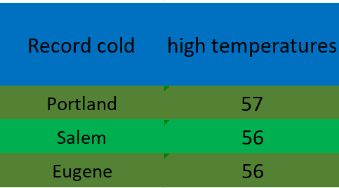
A solid half inch to inch in the valley and over an inch to two inches up in the foothills and mountains. The low pressure and steady rain was accompanied by chilly temperatures too. Record low high temperatures were set on Saturday all over the valley.

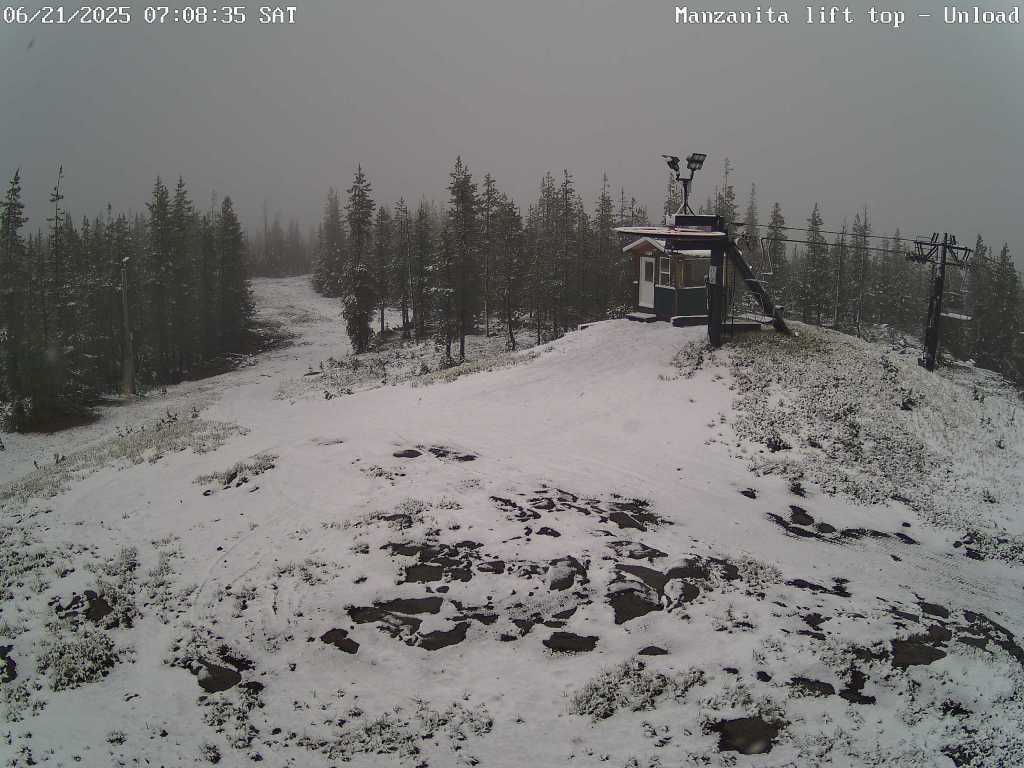
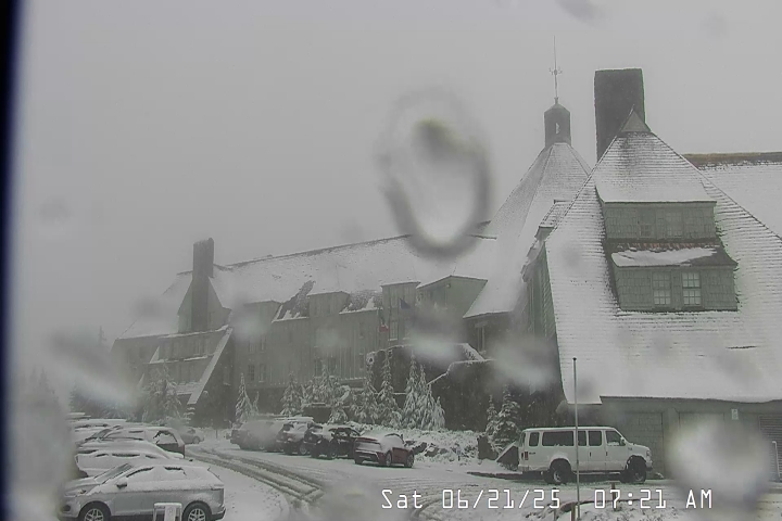
Snowfall also made it’s way to the Oregon Cascades. These two images show snowfall on Hoodoo and up at Timberline Saturday morning. Fun to see snow falling up there on the first full day of summer!

Forecast details

Tue: Very similar to the weather we saw today. Highs in the low 80s.

Wed – Fri: Each day will feature a very slight chance of drizzle or a few light sprinkles. Nothing widespread or heavy. Lots of cloud cover with sun breaks mixed in at times. Highs in the low 70s and early morning lows 53 – 55°. Best chance for any light showers or sprinkles looks to be Wednesday and Thursday with a lower chance on Friday.

Sat: Sunshine returns with highs in the lower 80s and mostly sunny skies. A real nice day after a refreshing start that morning with lows in the low 50s.

Sun & Mon: Sunny and warm with highs in the mid to upper 80s.

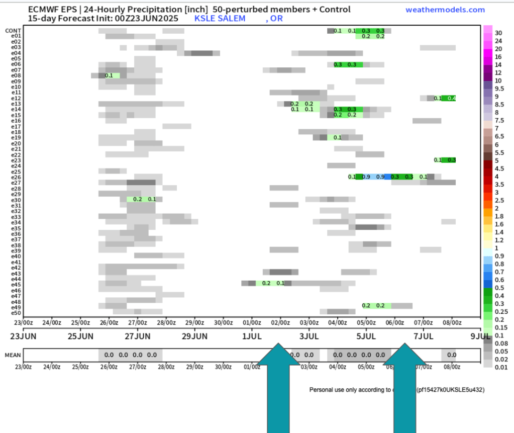
Looking further out to the first week of July it still appears we could have another shot at a few showers. Too far out to say with certainty, but there are enough individual members (horizontal lines) calling for rain at some point during the first week of July that it has my attention.

The biggest take away I see is that there is no sign of hot weather the next two weeks. Some upper 80s, but nothing prolong or real significant. I’ll keep an eye on that 4th of July forecast, but in the meantime enjoy the nice weather.

A weekend soaking and look ahead

It’s a beautiful Thursday afternoon and temperatures are in the low 70s here in the mid Willamette Valley. I have a short update on our wet weather plus a look into next week and beyond below.

The forecast

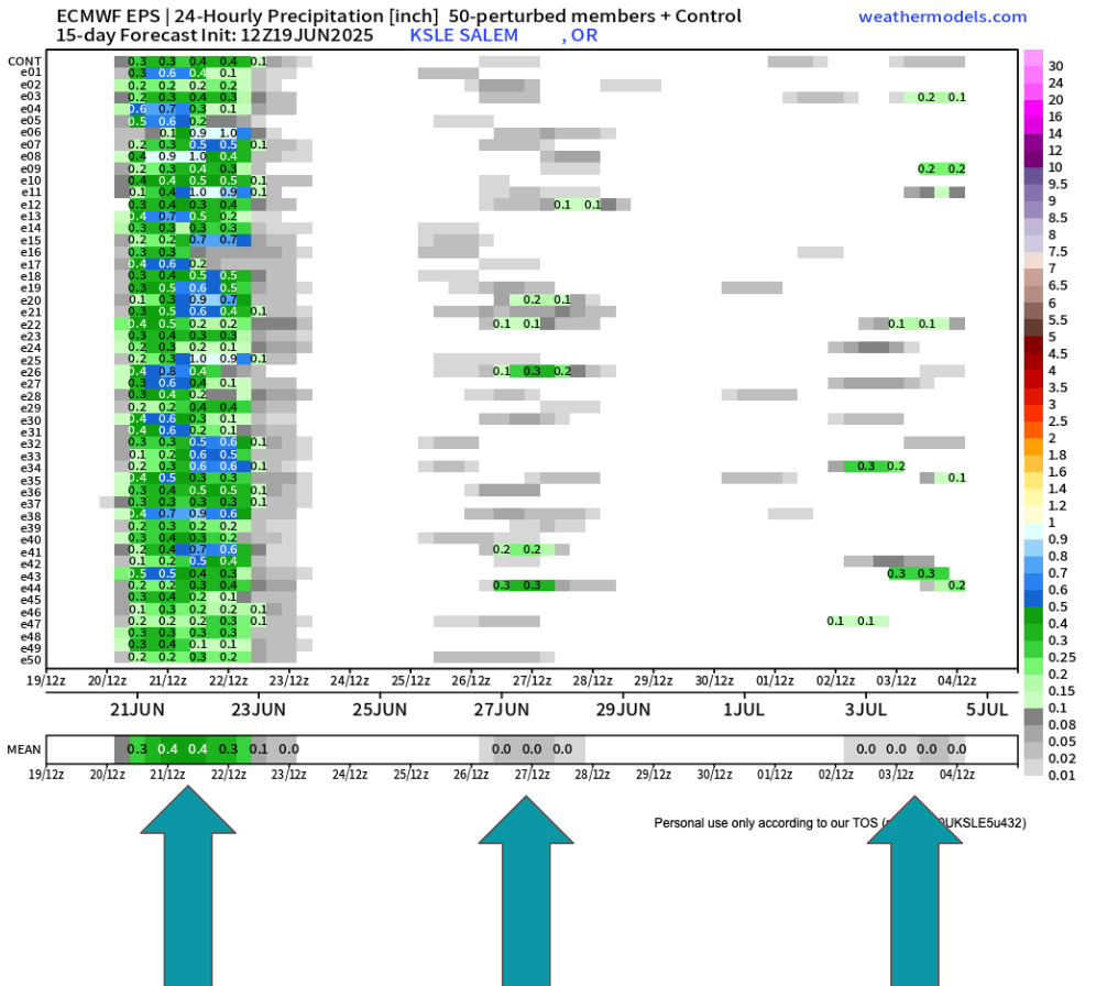
Our wet weekend is still very much on track. This weekend’s showers and rain show up very nicely on this ensemble chart. Remember, time goes from left to right on here and each horizontal line is a predicted outcome, and in this case, the outcome is precipitation. When viewing these charts we look for general agreement and trends.

Besides the soaking rain this weekend, you can spot the real light rain/sprinkle chance showing up for next Thursday (the 26th). I also noticed a higher than usual number of ensembles predicting a little bit of rain maybe the first few days of July. I’ll keep a close eye on that.

Friday will feature showers with just a few sun breaks here and there between showers. Quick hitting thunderstorms and heavy downpours are possible for all valley locations. The simulated radar image below does a good job depicting this scenario around 2pm Friday.

On Saturday we will actually see some steady rain during the morning/early afternoon hours before transitioning to a few showers later in the day. Again, downpours are definitely possible for all areas west of the Cascades. Steady rain will make it hard for high temps to top 60°.

Sunday: Expect this day to be mostly dry, but an isolated shower or two will require people outdoors to keep an eye to the sky. Overall a much better day weather wise for outdoor activities. Highs around 71°

Mon & Tue: Partly cloudy (more clouds during the morning hours) with lots of afternoon sunshine. Highs 80 to 83°

Wed: Increasing onshore flow again will lower highs back into the mid 70s with partly cloudy skies.

Thu & Fri: Could see another sprinkle or light shower (similar to what we just saw this past Wednesday) at any point during this time frame, but especially Thursday morning. Highs in the mid low to 70s with sun breaks mixed in.

Sat – Mon: June will finish on a warm note with highs in the mid to upper 80s and mostly sunny! A huge contrast to what we will experience this coming weekend.

Take care, enjoy the west weather the best you can, and don’t forget to pray for the people God puts on your heart today. Our world could use more prayer right now.