Hot first week of school

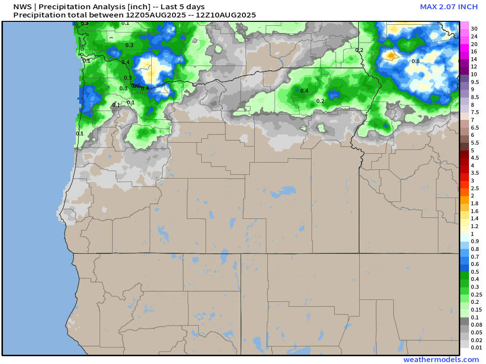
I’m pretty happy with how the thunderstorm forecast worked out. Storms in our region of the world are usually very tricky to pinpoint, and as expected some locations really go hammered hard by storms (parts of west Salem out towards Amity) while other locations didn’t get a whole lot, but enough about the past lol. Let’s dive into what’s ahead!

Headlines

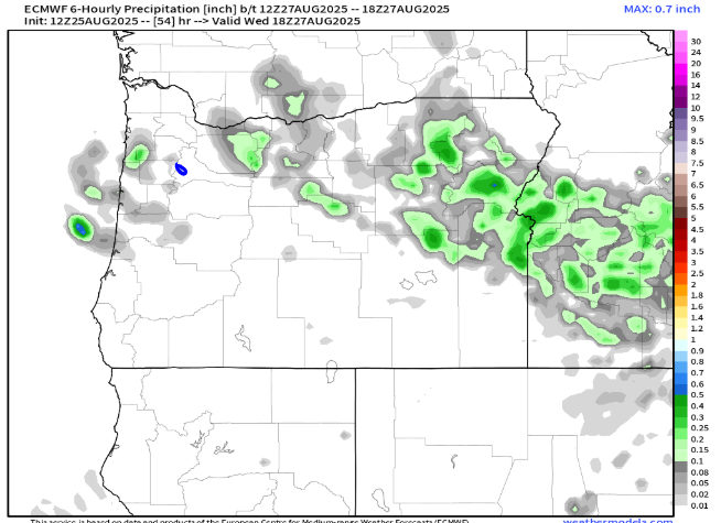
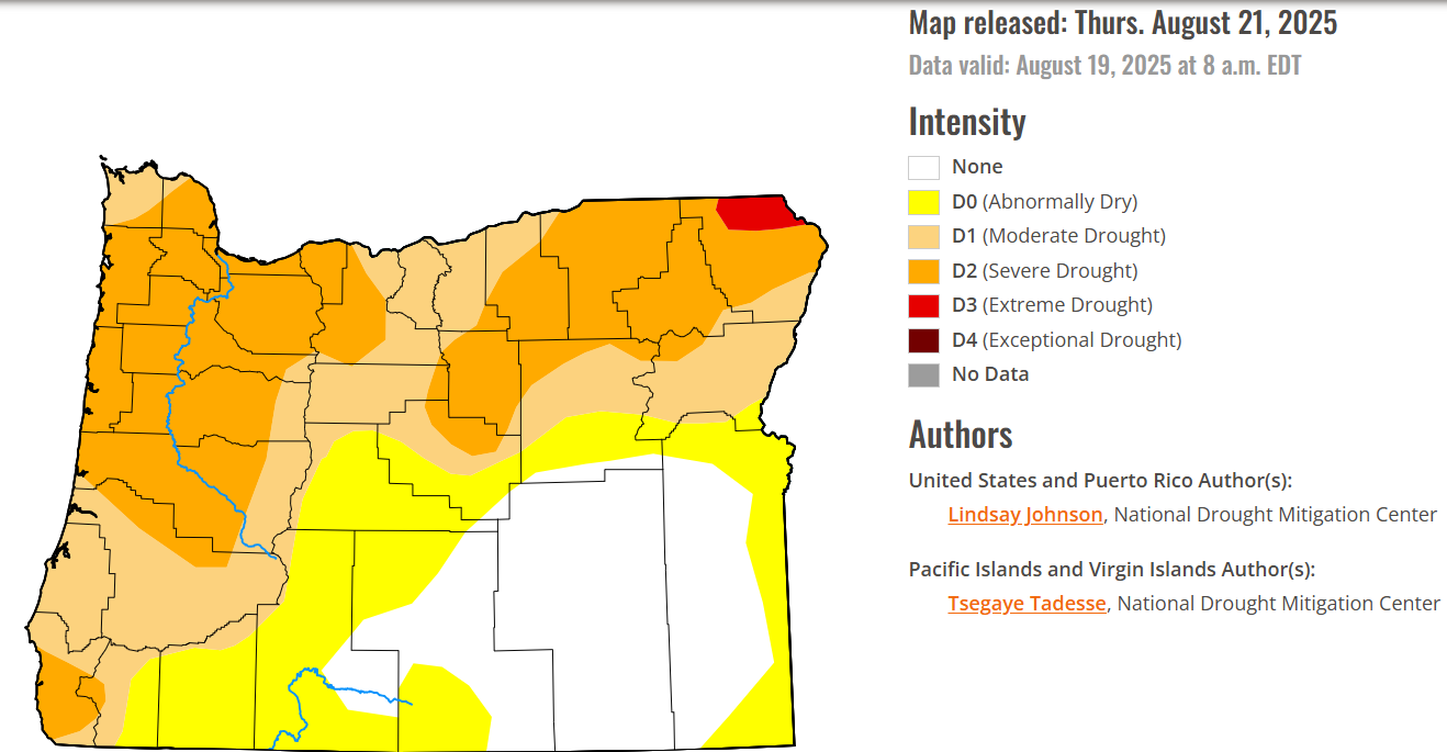
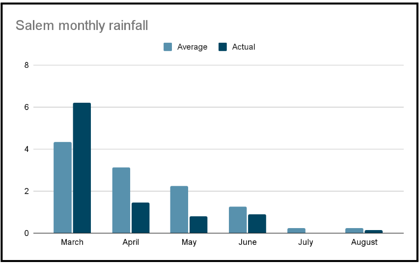
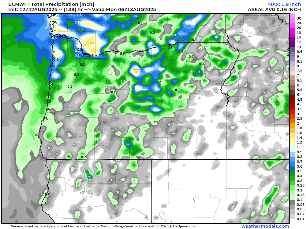
  • Salem and the mid Willamette Valley remain in a dry pattern for the next ten days – maybe even longer. 
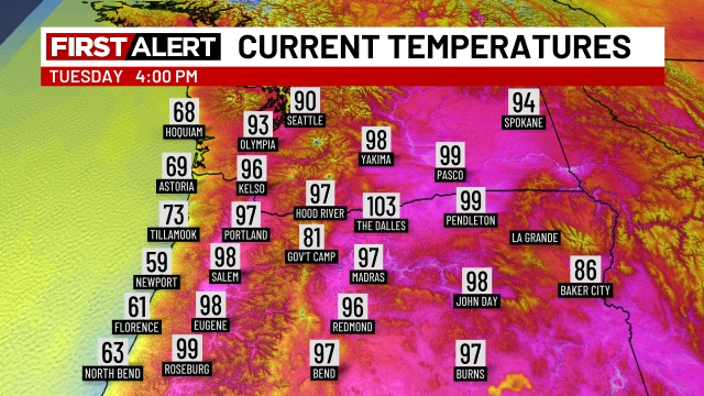
  • Temperatures stay on the warm to hot side of things with yet another heatwave this coming week.
  • Nighttime temperatures should be a little cooler than the awfully warm ones we have recently experienced.  Lows during the heat next week will range between 60 – 65° as opposed to 65 – 70° which is what we endured over this past week.
  • Classrooms in schools without AC are going to be hot for the first week of school.
  • Homes, apartments, and businesses without ac will also continue to be warm.

Details

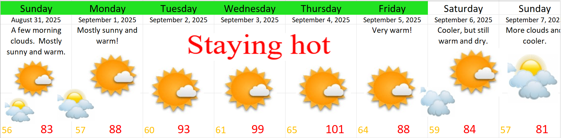
Friday: Cool start to the day with a morning low of 57°. Upper 80s for highs and plenty of sunshine.

Saturday: The coolest day of the next ten with morning clouds likely and partly cloudy skies lasting throughout the day. Lows start in the mid 50s before rising up to around 81°. A very comfortable day! There is a slight chance for a shower, but the vast majority of us will experience yet another totally dry day. Just something to keep in mind.

The rest of next week: We have another heatwave in store for this coming week, and terrible timing for the kids, teachers, and faculty who will be filling our school buildings next week. I’m fairly confident at this point in time that next week will be very hot.

The graphic below covers my thoughts pretty well. Keep in mind green highlighting around the days indicates high confidence in that outcome/forecast, no highlighting indicates a regular level of confidence, and should you ever see yellow highlighting then that would indicate a lower than normal level of confidence. Just something I like to remind people about when displaying this graphic, especially considering how long it’s been since I’ve used it!

Enjoy the warmth the best you can. It’s definitely going to be hot, but I always try to find enjoyment with all of our weather patterns. This season of warmth will eventually give way to the colder and wetter months of fall and winter, so enjoy the best you can and stay safe out there!

Additional storms possible

The forecast seems to be on track with locations in the Willamette Valley having already experienced thunderstorms this morning. Additional storms are possible anywhere west of the Cascades today, and east of the Cascades too for that matter.

We have an unstable atmosphere and sunbreaks will only aid to further destabilize the atmosphere making it ripe for a few storms. Not everyone will see rain or get lightning and thunder, but it’s a possibility.

Happy Wednesday!! 🙂

Very warm weather continues

For those of you crunched on time here’s the forecast:

  • Slight chance for showers and thunderstorms Tuesday afternoon through Wednesday.
  • Dry Thursday through most of next week. Highs in the 80s and lows finally back down into the upper 50s.
  • Slight chance for drizzle Saturday morning; otherwise, a warm and dry weekend.
  • Highs in the low 90s again next Tue – Thu, but with cooler nights (upper 50s to near 60°).

Details

We have two clashing forces at work affecting our nighttime lows: longer nights and cloudy/muggy conditions.

Yes, it is still summertime, but our sun angle is steadily lowering and it’s noticeable too. Salem has always lived in the shadow of Portland, and I could not find a graphic like the one below for Salem. Honestly though, in the scope of things the information is about the same.

At this point in the year the sun angle is about what it would be during mid April, so despite the very hot regime we are in at the moment, it will continue to become tougher and tougher for our temperatures to stay uncomfortably warm at night. Take for example the temperature swing from this past Friday afternoon to early Saturday morning. The temperature dropped exactly 40 degrees from 101° all the way down to 61° in just 14 hours. That’s impressive, and it’s a testament to both the very dry airmass we had in place to begin this heatwave, and the longer nighttime hours.

Countering that factor is the increasingly humid atmosphere and cloudier conditions which have been moving in. It’s true the clouds during the daytime hours limit heating some, but they also make it tougher to cool off at night. The morning low bottomed out at 64° here in Salem. Expect lows to remain above 60° through Thursday.

Another item to watch this week is a small disturbance in the atmosphere expected to drift from south to north directly over us Tuesday afternoon through Wednesday evening. At any point during this timeframe scattered showers and even a few thunderstorms could pop up anywhere west of the Cascades including the coast. The chances are not real high, and some of us will stay dry here in the valley, but keep this in mind as you’re out and about. Storms will generally be much more widespread over and east of the Cascades now through Wednesday night.

Below are images from two different forecasting models showing how isolated the storms and showers are going to be, and how tricky it is as forecaster trying to decide who to forecast which areas get storms and which areas don’t. This first image shows scattered showers running in a line just north and east of Salem extending all the way out to Astoria.

This second one does not have labels, so I added a small blue circle where Salem is located at. Again, only some of us here in the valley will see storms with this model thinking the central Oregon coast will be the place to be.

I share these images from time to time in my forecasts with the purpose of illustrating how tricky it can be to forecast scattered showers/storms. Don’t fixate on the exact locations in the maps above. Just focus on the general idea knowing that storms are a possibility anywhere Tue & Wed, but not everyone is going to be effected by them.

We have a slight chance for some light drizzle Saturday morning, especially northwest of Salem. Otherwise, plan on a warm and dry weekend.

Next week the warm weather continues with highs in 80s to low 90s Monday through Friday as we begin September. Lows should be cooler this time around staying in the upper 50s at least.

Drought update

Many of you have probably noticed we have been dry, and it’s true, we are running below average for precipitation across much of the state of Oregon, and the drought monitor map reveals this well:

We have lacked significant rainfall which is not uncommon for summer here, but what is a little uncommon is we have seen drier than average months since April. The chart below shows monthly precipitation for Salem going back to March which was the last time Salem had a wetter than average month.

It’s nothing to be too worried about, but something I’m keeping an eye on and will update you as we get closer to fall. Typically, fall rains easily erase any drought fears left behind from a dry spring & summer.

Take care and happy Monday!

Intense heat

The forecast through Wednesday is looking extremely hot, especially during the afternoon and early evening hours each day. Highs 98 to 102° today – Sunday. So much for a not so hot summer lol… Lows will at least drop into the low to mid 60s each night with temps being cooler the further from urban heat islands you go. Upper 50s are likely in most outlying and rural areas. This is thanks to the longer nights. I checked, and we have lost about two hours of daylight since the summer solstice. I personally really enjoy the long evenings of summer, but regardless of how we feel about the season changing, we can’t stop it, and a benefit of the longer nights is cooler starts to the day – even during a heatwave.

For Monday I’m going with a high of 92° assuming we see some cloud cover cover from dissipating thunderstorms known sometimes as “debris clouds.” If we get significant cloud cover that day, we could top out closer to just 90, but if clouds are minimal, then we will see another day where highs approach 100. Either way, still a very warm airmass.

Tuesday: Highs in the upper 90s to near 100° again.

Wednesday: Highs in the lower 90s.

Thursday: Highs finally return to the 80s.

The Cascades and central OR

Beginning Sunday afternoon and lasting through at least Wednesday of next week, the Cascades and parts of central Oregon will see afternoon and evening thunderstorms. Lightning could spark additional wildfires, and lightning, locally heavy rain, and hail could be cause dangerous conditions for hikers, campers, and anyone outdoors.

No need to cancel outdoor plans in the beautiful outdoors. Storms will be scattered in nature, so not everyone will see action each day, but be aware of it if you have plans in these areas. Simply keep an eye on the forecast each day and if you see clouds building/bubbling up, then that’s a good sign of healthy convection and consequently a good sign to maybe pause your outdoor adventure. Storms will generally move from south to north with this type of weather pattern, but will take on a more northwesterly direction Sunday night and Monday which is why we could see more cloud cover that day.

I’m at the end of the post and I realized I prepared no fun graphics, charts, or colorful images, so I thought I would share this silly photo I took the other day. I drive past this tree on Cordon Road often, and each time I feel like it looks like a monster – a friendly monster of course lol, but I had to pull over and take a pic so I could SAFELY get a better look. Anyway, I leave you with this. Be safe out there, stay hydrated, and watch out for friendly monsters roaming around Cordon Road haha. 😀

Humid and rainy

The quick version

Details

Overall things worked out, but forecasting what are known as “atmospheric rivers” will always be tricky. Atmospheric rivers were once described to me as a loose firehose wiggling around and spraying in many directions. Trying to predict where it will spray next and for how long are difficult things which forecasters may never truly understand. The storm itself was strong for this time of year and moisture laden**. It just didn’t linger over the valley for a long time.

The next image shows up best if you’re view it on the website versus the email report. It’s a slider tool and you can easily compare what was forecasted versus how much rain we actually received.**

Heatwave update

Headlines

  • More comfortable weather Wednesday and Thursday. Still warm, but no more heat.
  • Humid and damp Friday and Saturday with widespread showers likely.
  • Warm nights continue through Friday night.
  • Cooler morning lows in the 50s begin on Sunday and last through next week.
  • Regular warm and dry weather next week and the following weekend.

Details

Phew! We are making it through the hottest stretch of weather we have seen all summer long. As of 4pm our area temps look like this:

Pretty hot out there!! Not only did Salem see back to back highs above the century mark, but our lows have been warm too. It took until 4AM before we finally fell below 70 degrees Monday morning which of course lead to a sweltering high of 102° yesterday. This type of heat makes for a long day of attempting to keep the house cool when you can’t get cool air from outside during the night. Tonight, we are headed for the low 60s tonight which is slightly better than what we have seen lately.

Pretty typical summertime weather Wednesday and Thursday. This means mostly sunny skies, maybe a few clouds here and there, and highs in the 80s. The heat will be over. We’ve actually had a pretty decent summer in regards to heat when compared to the past several summers. For example, last summer Salem saw a total of 38 days at or above 90 degrees, and so far this summer (including today) we are “only” at 17.

Friday and Saturday will bring a fairly substantial opportunity for rainfall. Quite a bit more than what we saw with last week’s sprinkles. This setup will likely provide our region with a good soaking. Last week’s rain did not penetrate very far south or east into Oregon, and really favored the northwestern portion of the state as you can see from the map below:

The rain we’re expecting Friday and Saturday will be more widespread in its extent. This next image shows estimated rainfall totals for our incoming storm.

Significantly more rain further south and east than what we saw last week. Despite the expected rainfall, it’s going to feel rather uncomfortable and humid both Friday and Saturday. Warm and moist southwest winds coupled with cloud cover will make for a sticky couple of days as lows only dip to the mid 60s each night.

Relief comes Saturday evening as the cold front moves through. Temperatures early Sunday morning will begin in the upper 50s. Afternoon highs around 80° with a leftover shower possible, especially up in the foothills and Cascades.

Regular dry and warm summertime weather returns Monday and lasts through the following weekend (Aug 23rd and 24th). This will indeed be a very nice stretch of weather with highs in the 80s each afternoon and lows regularly dipping into the low and mid 50s. Highs gradually warm each day through the week with upper 80s by next weekend.

Enjoy the weather, and stay safe out there!

Showers for Wednesday

Wednesday is going to feel like a super early taste of fall. If you don’t want summer to be over yet, well don’t worry, summer weather is poised to make a quick return by the weekend. In fact, we could be looking at highs at or slightly above 100 degrees next Monday.

Details

Wednesday: Showers and light rain push in before sunrise with scattered showers lasting on and off throughout the day, but lessening as we head into the afternoon. Highs just barely reaching 70 or so. Rain should fall for most locations west of the Cascades from Eugene northward. Western Washington and the Olympic Peninsula up there could see upwards of a half inch of rain or more. Great news for fighting fires burning that way!

Thu & Fri: A few morning clouds with afternoon highs 80 – 84°.

Sat: Significantly warmer with highs in the upper 80s.

Sun – Tue: Highs in the 90s to 100°. It’s going to be a real hot stretch with lows only dipping to the mid 60s.

Next Wednesday we return to more usual warm summer weather with mid 80s for highs.

Enjoy the weather whiplash haha and stay safe out there!