Showers, sunbreaks, and storms

Oh my!

Haha! Well, we are right in the swing of things with plenty of clouds and showers roaming around today. The sunbreaks have been limited, but we should end the day with a few more peeks of sunshine than we started the day with. Plan on seeing a lot more in the way of sunbreaks Thursday with scattered showers and downpours still mixing in at times.

Everyone’s getting rain in this type of pattern, but the showery nature of these downpours have left us with very uneven rainfall totals, and that’s how it goes in this type of setup. With another day of showers still to go, I feel confident saying that all of us will see additional rainfall before the large “parent low” responsible for these showers finally moves off Thursday night.

Friday: Mostly dry with morning fog likely and partly cloudy skies during the afternoon. Highs in the upper 60s.

Sat & Sun: An important update here. We can no longer rule out a shower or two on Saturday. The vast majority of the day will be dry, but I’m expecting our region to just get clipped by a passing system which will jeopardize our completely dry Saturday. Sunday still appears to be 100% dry.

Mon – Wed: Dry and mostly sunny. Patchy morning fog in some locations. Chilly mornings will give way to warm afternoons each day. Lows ranging from 42 – 46° and highs topping out between 73 & 77°. Extremely nice weather if you ask me, especially after the rain and clouds this week.

Rain becomes more likely again next Thursday.

Enjoy all that God’s beautiful creation has to offer and stay safe out there!

Showery fall weather

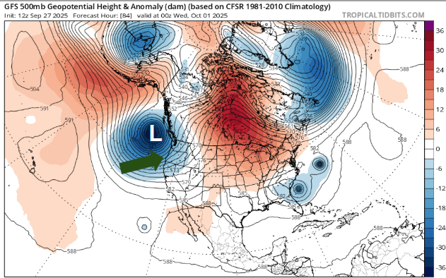
Showery and cooler weather is upon us, and today’s weather definitely gave off cozy stay at home vibes. The image below shows the weather pattern at 500mb (18,000 feet up into the atmosphere) valid for this Tuesday evening. In general, the deeper blues indicate much colder than normal temperatures for that altitude, and the red/orangish colors indicate much warmer than normal temperatures. I have added an arrow pointing to Oregon, and a white “L” to show the center of the low pressure system giving us rain and showers this week.

You can also see the hurricanes off our our nation’s east coast which will fortunately turn away from the mainland – excellent news!

The next image is a fresh 7 day forecast. I like the visual and will try to use this one more often during this upcoming fall and winter season.

Details

Tue: A mostly dry morning. Increasing clouds with rain arriving during the afternoon. Wind gusts of 25 – 30mph. Not super strong, but stronger than we have seen in awhile…

Wed: This day really seems like a classic shower and sunbreak type of day with the weather changing throughout the afternoon. Warm sunbreaks will destabilize the atmosphere leading to downpours. Brief gusty winds 25 – 30mph possible at times.

Thu: Similar weather to Wednesday in that we will have both an unstable atmosphere & a few disturbances riding through the region. Expect additional downpours with sunbreaks mixed in.

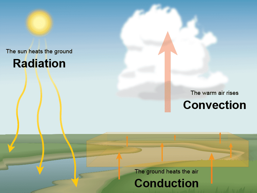
As we head further into our wet season, you will hear the phrases “unstable atmosphere” or “convection,” from time to time, and I thought now is an excellent chance to remind people what those things mean. An unstable atmosphere usually indicates that there is cold air up above us (aloft) with warmer air near the surface and plenty of moisture around. Solar heating from sunbreaks warms the moist air near the surface causing it to rise. These rising columns of air eventually cool and condense leading to the formation of clouds, showers, and thundershowers. It’s this process of convection which drives a lot of these heavy downpours of both rain and hail during this cooler time of year. So now you know!

Friday: Partly cloudy and dry.

Sat & Sun: Partly cloudy Saturday, and mostly sunny Sunday. Both days should be dry.

Next Monday – Wednesday: Chilly mornings and warm and sunny afternoons. Lows in the low 40s and highs 72 – 75°.

Have a great and safe rest of your week!!

Additional sunny days on the way

Headlines

  • Mild and sunny through Saturday.
  • We squeak out a dry Sunday with rain moving in very late Sunday night.
  • Showers each day Monday through Thursday of next week.
  • No major rain storms or strong wind storms.

Details

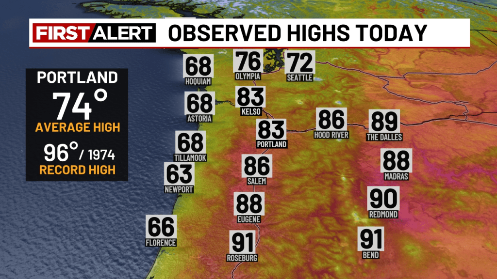
Highs from Wednesday reveal widespread 80s across the Willamette Valley with cooler temperatures along the coastline. Another beautiful sunny day!

Temperatures this afternoon will reach the mid 70s before cooling off quickly this evening. Tonight we are headed for lows back into the upper 40s.

Friday: Mostly sunny with just a few clouds. Highs in the mid 70s again.

Saturday: After a chilly start with lows around 50, the afternoon will feel warm under mostly sunny skies. Highs near 84°.

Sunday: Partly cloudy with increasing clouds and dry. Highs in the upper 70s.

Mon – Thu of next week: This will be our longest stretch of wet weather since last spring. Scattered showers possible each day. I see no big soakings, or in other words, I don’t see any time next week where it is rainy the entire day. Just periods of showers with occasional sunbreaks. Right now Tuesday and Thursday look to be the driest days of this stretch with the least amount of showers, but I’ll try my best to provide an additional update as time gets closer.

Stay safe out there and enjoy the amazing weather!!

Mild September weather

This past Tuesday was a quick throwback to summer with highs reaching a hot 93°. This tied the record set in both 1929 and 1994. We quickly returned back to more typical September weather. Our average high for the next few days is 77° and our average low is 50. Here are the highlights for the next several days:

  • The mild September weather many of us know and love continues through most of next week with this Sunday being the one exception.
  • Highs in the upper 70s to mid 80s almost every afternoon next week – warmer than average.
  • Morning lows ranging from 48 – 54° – right around average.
  • Rain for Sunday morning will give way to a dry afternoon & evening.
  • No sign of any big or significant rain storms just yet…

Details

Both the remainder of today and Saturday look pretty similar: warm afternoons with cool nights & mornings. Excellent early fall like weather in my opinion!

Sunday: Light rain passes through the region during the morning hours, but this storm is weak and moving at a quick pace leaving us with a mainly dry afternoon & evening.

Monday: Morning fog is possible. Fog really becomes increasingly likely this time of year due to higher relative humidity, lower temperatures, and a weaker sun angle. AM low of 49° and a high in the mid 70s.

Tue – Thu: Warmer afternoons with highs reaching the mid 80s, but lows will continue to dip down to right around 50°.

Next weekend: Still too far out, but some showers seem likely again for at least a portion of the weekend as we slowly slip closer and closer to the wet season. More details in future posts as details become more clear.

Okay, stay safe out there and enjoy the beautiful weather!!

Updated forecast

The forecast has generally stayed on track this week. Looking back over the past several days I’m pleased with how things turned out. Heavy downpours hit parts of Salem and the Willamette Valley both Monday and Tuesday; however, the downpours were very isolated in nature creating uneven totals. Some valley locations picked up over a third of an inch of rain in less than an hour Monday. Meanwhile, other parts of the valley stayed totally dry, and that’s just the nature of that type of weather setup.

Look ahead

Saturday: A fantastic day! Plenty of sunshine after a cool start with a high of 82°. Very nice!

Sunday: Showers at times throughout the day. Not a washout though, and there should be dry times scattered between the showers. High around 72°.

Monday: I could see this day starting out with either morning clouds and or even some patchy fog due to leftover moisture before warming into the low 70s with afternoon sun.

Tuesday: Summer weather returns with highs soaring into the upper 80s, but it’s mid September, and this time of year it takes all day to really warm after the longer and cooler nights. Have you noticed how much cooler our nights have been finally? The warm humid nights which dragged on through the first part of the month are long gone and have been replaced by much more typical September temperatures. Lows Tuesday morning will start out between 52 and 54°.

Wednesday: Cloudy and cool with drizzle and a few sprinkles possible during the morning hours. Highs slowly climb to the low 70s with afternoon sunbreaks.

Thu – Mon: Currently this entire stretch of days looks to be fairly warm and dry with Thursday being the cloudiest and “coolest” day due to cloud cover. Pretty typical fall weather with lows ranging from a crisp 48 – 52°, and afternoon highs in the upper 70s to low 80s Friday through Monday. September is historically one of our nicest months of the year, and for at least the next 10 days it looks to maintain that reputation.

Enjoy the nice weather and stay safe!

Thunderstorms and showers

Greetings! It’s been awhile since the last update. Had a busy, but really fun weekend sneaking in some camping before summer weather comes to an end, and I hope you all had a great weekend too! I’m back in the saddle again with a quick update covering the rest of our week. 🙂

Highlights

  • Scattered downpours likely this afternoon through Tuesday evening.
  • Some of these downpours could produce lightning and thunder.
  • Plenty of sunbreaks and dry times in between.
  • We dry out with partly to mostly sunny skies Wed – Sat.
  • Shower chances increase again on Sunday.

Details

For the rest of today through Tuesday evening the Willamette Valley will be under the influence of an upper level low. This low will produce scattered showers of varying strength. Due to the scattered nature of these showers, most locations should experience plenty of sunbreaks during the in between times.

These showers have the potential to be very heavy with lightning and thunder also being possible. Some of these showers, especially the ones which pop up Tuesday, could be slow moving resulting in localized downpours. It’s virtually impossible to know exactly where the showers will pop up in this type of pattern; however, I’m confident by this time Wednesday a few of you will have picked up some hefty rainfall totals (more than half an inch). The map below shows the estimated radar for 6pm Tuesday evening, and illustrates the potential for scattered storms fairly well.

This forecasting tool is advertising several extremely heavy scattered showers dotting the Willamette Valley between Corvallis and the Portland metro. Notice not everyone gets a huge storm or soaking, but if a storm happens to move across your neighborhood then it becomes a pretty big deal.

The Willamette Valley dries out Wednesday, and we stay dry through Saturday. Our next threat for showers doesn’t show up until Sunday. Highs in the mid 70s Wed – Fri. Highs reaching the low 80s on Saturday.

The Cascades and central Oregon

Showers and thunderstorms remain possible in the foothills and Cascades each afternoon and evening through Thursday. As this upper level low slowly moves eastward, central and eastern Oregon will also experience some very heavy thunderstorms. Everywhere from Klamath Falls up through Bend and out over to La Grande can expect big soakings coming up this Wednesday and Thursday!

Most mountain locations finally dry out for both Friday and Saturday.

There you have it! Enjoy whatever heads your way and stay safe out there!

Hot week and more thunderstorms

Headlines

  • Hot afternoons this week equals hot homes, businesses, and hot classrooms for this first week of school.
  • Clouds and increasing smoke keep the extremely hot temperatures at bay.
  • Clouds and increased humidity will result in warmer nights.
  • Slight chance for thunderstorms/showers tonight and Wednesday.
  • Higher chance for more widespread thunderstorms and showers Friday night and Saturday.
  • Thunderstorms are likely in the Cascades each afternoon and evening today through Saturday.

Details

The heat is still on, but with a familiar plot twist. Similar to what we experienced last week, thunderstorms and clouds from dissipating storms are going to keep the hottest temperatures down, but with the clouds comes increased moisture. The humidity this week cause nighttime temperatures to be noticeable warmer than what we experienced this past weekend. Expect lows to range from 62 to 65° through Friday night. Lows return to the 50s again come Sunday morning.

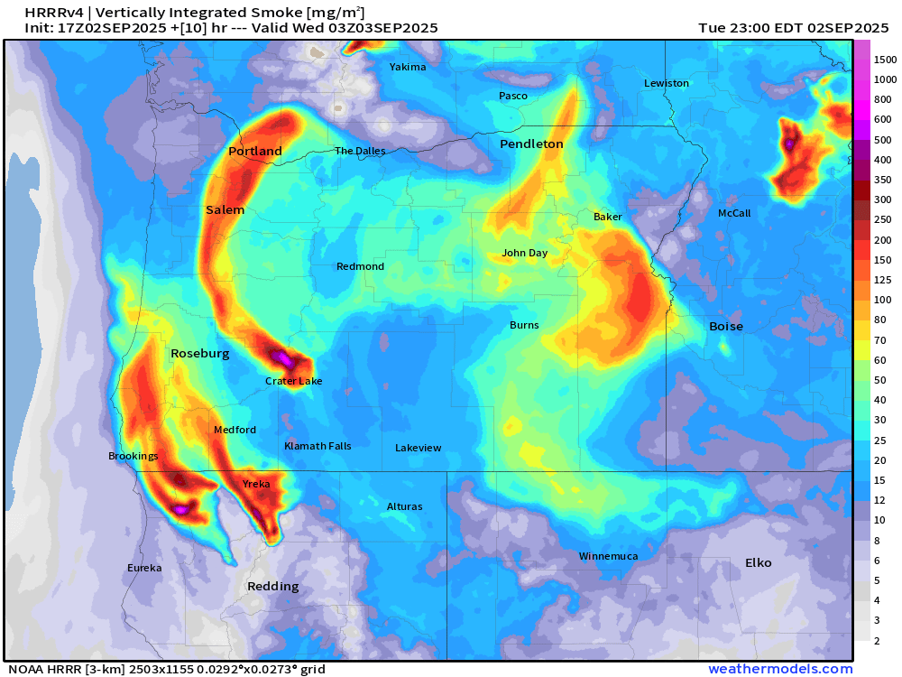
Smoke (mostly high above us) will become more pronounced today. This makes for hazy skies, and consequently, lower daytime high temperatures than what I was predicting just a few days ago. I’m thinking we hit 92° today. Below is a forecast showing smoke density through the atmosphere. Smoke here in Salem should primarily stay above the surface, but it will make for a hazy sunset tonight.

Tonight and Wednesday: A small disturbance, quite similar to the one we saw last week (which triggered a few storms), moves northward late tonight through Wednesday. This has the potential to give anyone either a shower or a thunderstorm tonight through Wednesday night. Highs Wednesday topping out only around 85° due to cloud cover. The majority of locations stay dry for the majority of the day tomorrow. Just know we have a slight shot at seeing a shower or storm anywhere.

Thursday: Mostly sunny skies coupled with a hot atmosphere will allow highs to soar into the 90s! High of 94°. Smoke or leftover clouds could once again hinder this forecast, but for now Thursday is looking hot and mostly sunny!

Fri & Sat: Warm with highs well into the 80s on Friday, but with increasing clouds and threat for widespread thunderstorms and showers beginning Friday evening. Storms and showers are even more likely Saturday & Saturday night. Highs Saturday are capped at around 80° due to cloud cover and showers.

Sunday: Partly cloudy with highs in the low 80s.

Mon & Tue: Showers likely. Highs in the mid 70s.

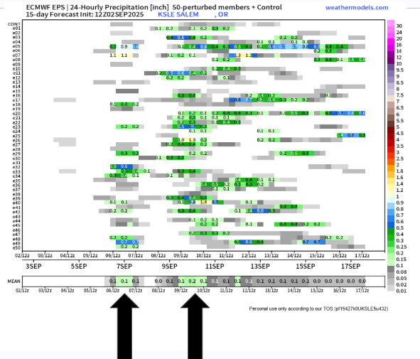
The chart below is a helpful tool I enjoy using, especially during our fall and winter season. Remember, time goes from left to right when reading this chart, each horizontal line is a potential outcome being forecasted by this computer (in this case rainfall for Salem, OR), there are 51 potential outcomes on here, and what we are looking for is consistency. The more consistency we see, then the more confident we can be in that general outcome taking place.

On here we can see the rainfall potential for Friday night and Saturday indicated by the first arrow, and the second arrow shows the widespread showers expected next Monday and Tuesday.

That’s all for now! Enjoy the heat the best you can, and stay safe out there!!