Frigid March weather

It’s March 4th, but it sure doesn’t feel like it.  We are currently under the influence of a modified arctic air mass.  At my place in the hills of south Salem I recorded a low temp of 18°!!!  Check out the extremely cold temperatures across the region from this morning.

7am temps 3.4

Doesn’t look like March…  Here are a couple of pics from earlier this morning which convey pretty well just how chilly it was out there.  The first pic is east of John Day, and the second pic is the top of Santiam Pass by Hoodoo.


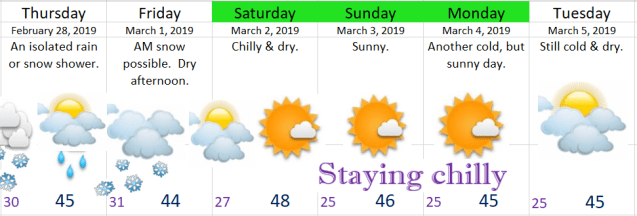
Extended forecast

Cold March Forecast

Highlights & Details

Rest of today & Tuesday:  Very cold, especially at night and through the morning hours.  Lots of sunshine.

Wednesday:  Subject to change; however, confidence is growing that we will see some light snow, or a wintry mix of ice and snow before switching over to a rain/snow mix during the afternoon hours.  This could be similar to the little snowstorm we had last Tuesday night/Wednesday morning.

Thursday:  A few showers.  Snow could mix in as we stay in a chilly pattern.

Friday:  Heavy showers with wet snow, ice pellets, & hail all possible.  Staying cool.

Saturday:  Showers possible.

Sunday:  Drying out and sunny.


Snowy central Oregon and cold start to March

Happy Friday!!  I’ve revised the forecast for today as we should be dry the rest of the day, but staying chilly.  This will kick off a multi-day stretch of dry weather with the next chance for precipitation not showing up until Wednesday.


Next I wanted to share a few images with you all to help convey just how much snow is on the ground east of the Cascades. 

First up is a satellite pic from yesterday before the clouds moved in all the way.  Some of the white you see are clouds especially along the edges, but for the most part it’s all snow cover from the Cascades eastward.  Have I told you how much I love the clarity of this new satellite?  Notice how you can easily see both the Columbia and Snake Rivers as they flow through the frozen landscape.  Pretty neat ehh?!?

snow cover 2.28

Next I have several images saved from various traffic cams over the past few days.  Most of these come from Central Oregon where 25 to 35+ inches of snow have fallen this week alone!


Lastly I have a few pics from Bend, OR taken Thursday morning where they have received over 30 inches of snow over the past several days.  Absolutely incredible!!!  Photos taken by Darius Marvasti.


Speaking of snow, check out these images showing how the snowpack in Oregon has progressed from early December to now.  A major turnaround from where we started!


Looking ahead I see several dry days headed our way.  This dry weather will be accompanied by some very cold temperatures.  It will be the battle of the seasons with the early March sun versus the very cold air mass.  As a result I expect morning lows to dip all the way down into the low to mid 20s Saturday through Wednesday.  For the afternoons I’m banking on the early March sun getting us up close to 50° despite the very cold mornings.  You may not think upper 40s/close to 50 is all that warm, and it isn’t, but keep in mind that if we had this very same air mass in January we would be talking about highs in the mid to upper 30s instead.  Just a little perspective for you 😉


PS.  No lengthy snowstorm recap, but I was happy with how everything turned out Tuesday night/Wednesday morning.  It appears as though everyone recieved about 1 to 2 inches of snow here in the Salem area.  Felt nice to have a snow forecast pretty much work out 🙂

Feb 27th forecast

I will likely give a little storm recap later, but I’ve got to say I’m happy with how the forecast turned out.  I’m even more happy everyone reached the 1 to 3 inch range this go around!  The colder temps obviously helped out a lot.

Extended forecast

Feb 27

Looking ahead I can’t find any sign of warmer weather, but at least we have several dry and sunny days coming up.

Thursday:  Just a couple morning snow showers possible.  Dry much of the day with some late afternoon rain or mixed showers.  Little to no accumulation.  Maybe up to an inch in the higher hilly areas.  No travel concerns.

Friday:  Watching for another chance at a snowy morning before slowly drying out during the afternoon.

Saturday – Tuesday:  Cold & dry.  Morning lows will dip well into the 20s and even with the sunshine, high will only make it into the upper 40s.

Another snow event

First off a quick little demonstration on how a little bit of elevation can make a huge difference in weather conditions. This first pic is from roughly 200′ in elevation.  The next pic is my neighborhood at 475′ in elevation.  Both pics were taken Monday morning.


Moral of this story is that snowfall totals can vary quite a lot even right here in Salem/Keizer which is just another reason why predicting snowfall is such a pain.


Moving on, I’m tracking another snow event heading our way with some factors working against us seeing a bit of snow and some factors working in our favor if you’re rooting for more snow.

One factor working against a lot of snow tonight would be this dry air.  Dry air means precip has a tougher time reaching the ground.  Another factor to consider is this storm has less moisture than the last storm which again equals less snowfall potential. 

Working in our favor for a bit of snow are the cold temps.  Across the region we are a solid 3 – 6 degrees colder than this exact time Sunday.  This means it will not take long at all for snow to begin sticking this go around.  The second factor working in our favor for more snow is the trend.  They say “the trend is your friend,” and the trend on the weather models today has been increasing the precip tonight.  This of course means the opportunity exists for us to exceed current snow forecasts including my own.

With all that said I expect many of us will receive somewhere between 1 & 3 inches of snow.  Sadly, there’s almost always a “loser” when it comes to snowfall in these parts, and I imagine some of you will see less than an inch.  Either way be prepared for area roads tomorrow morning to be icy, slushy, and or snowy.  It’s late February though and the roads should be just wet by mid to late morning thanks to the increasing sun angle and longer days.

I should have an updated look ahead and a quick update on tonight’s storm later this evening.

Be safe

Feb 25th storm recap & forecast

Time for another addition of “The Good, the Bad, & the Ugly!”

The Good, the bad & the Ugly!

I’m sitting here tonight happy that everyone got at least a little bit of snow (good).  My forecast of 3 to 5 inches was too high (bad).  Totals ended much closer to 1 to 3 inches.  The higher hills in south Salem received 3 inches (good).  Everyone else ended up closer to the 1 inch range (bad).

The Eugene and Springfield area received some very heavy snowfall with 8 to 14 inches for most locations south of roughly Junction City and Brownsville (good).

The temperature last night in Salem was a couple degrees warmer than I anticipated which resulted in a longer and slower than expected transition from rain/snow mix to all snow last night (bad).

It’s been a cold day.  The sun never came out and we stayed in the 30s all day long (good).  In fact our high temp today was 38° recorded just after midnight before the rain, snow, and colder air moved in.  Our “daytime high” temp was only 36°.

It wasn’t a huge storm or even close to it for the immediate Salem area, but as you can see we were not far from receiving much higher totals had the snow band stalled just a little closer to us.  See how a little distance can make a huge difference??


All things considered I feel good about how the forecast turned out.  A little bummed it ended up being another mediocre snow event here in Salem as we yet again managed to avoid the heavier snow, but I’ll take 1 – 3 inches over nothing almost any day. 🙂  😉

Here’s some pics from around the region to help give an idea of the different conditions experienced.  This first set is from the hills of south Salem.

This pic comes from the hills of Eugene courtesy of Micah Sardell where 16 inches fell!!

Eugene 2.25 Micah Sardell

And last, but not least, from my own backyard 😉


A look ahead, and sorry, but no super fancy graphic tonight 😉

Tonight:  Cold & dry.  A very chilly night with lows getting into the mid to low 20s.  Icy roads likely in spots.

Tuesday:  Very cold start, but should stay dry.  Highs in the upper 30s.

Wednesday:  Light snow during the morning hours transitioning to flurries or even some sprinkles during the afternoon.  For now I’m leaning towards just a dusting to an inch tops.  I expect no real travel issues Wednesday unless this storm ends up being stronger than current forecasts are predicting.

Thursday & Friday:  The threat for snow & rain showers continues with highs in the upper 30s to low 40s and lows generally between 29 and 32°.

Saturday – Monday:  Lots of sunshine, very cold mornings, and dry.  Lows 22 – 26°, and highs 44 – 50°.

Will be watching late Tuesday night through Friday for any changes, but as of right now I’m not seeing any major snow events during this time frame.


The Cascades and Beyond

Up in the mountains, and basically everywhere east of the Cascades it’s been ridiculously snowy, and with more snow on the way I don’t expect easy travel condions in those parts anytime soon.
Snowstorm update and week ahead

A snowstorm for the mid and southern Willamette Valley looks to be right on track for tonight and tomorrow morning. 

Timing & details:  Sometime around 10 or 11pm a rain/snow mix will begin.  It won’t take very long to switch over to all snow.  Snow will continue through the early morning hours before changing to a few light snow showers for the rest of the day and possibly lasting into the evening.  Corvallis down to Eugene should score some really big snow totals.  Quite likely in the 7 to 12 inch range.  The Salem area will likely be lower with 3 to 5 inches being a likely outcome for us.  The Portland metro area will likely receive the lowest snowfall totals with only a dusting to 3” likely up there. 

Keep in mind how small shifts in the track of the storm can make big differences regarding snow totals.  One of the game changers I mentioned yesterday is that if the storm and main precip band moves a little bit further from where it’s forecast to go than we could easily see more (or less) snow.  Right now I’m happy with the 3 to 5 inch forecast, but don’t be surprised to see more than that.

You can also keep tabs on the incoming storm with this link right here.  You can see a nice stream of clouds and moisture headed right into Oregon, and with cold air coming in we have the right ingredients for a nice snowstorm!

http://rammb-slider.cira.colostate.edu/?sat=goes-17&z=1&im=14&ts=1&st=0&et=0&speed=80&motion=loop&map=1&lat=0&opacity%5B0%5D=1&hidden%5B0%5D=0&pause=20190225014718&slider=-1&hide_controls=0&mouse_draw=0&follow_feature=0&follow_hide=0&s=rammb-slider&sec=conus&p%5B0%5D=geocolor&x=4328&y=3416


Rest of the week

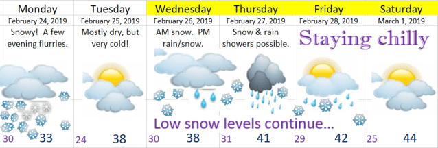
Feb 24

Tuesday:  Very cold, but dry.

Wednesday – Friday:  More snow opportunities as we stay in an unusually cold wintry pattern.


Winter Strikes back!

Ready for an incredible Photoshop job?  Well here it is!  Kind of silly I know; however, it accurately depicts my feelings right about now concerning our upcoming snowy & cold winter weather.

Winter Strikes Back

Basically we have a very good shot at a snowstorm Sunday night through much of the day Monday with potential for more snow over the course of this coming week.  This the most certain I’ve been about snow falling in the Salem area since I began this website last winter.  Let’s get to it!!  I’ll give the highlights first along with the extended forecast, and then if you’ve got time I have the all-important “game changers,” & and a few closing thoughts further down.

Feb 23

Highlights

Tonight/Sunday morning:  Most likely just rain.  There’s a slim chance some of you will briefly see accumulating snow very early Sunday morning before switching back to a cold rain as the day wears on.

Sunday:  Cold rain.  In some places a rain/snow mix at times.

Sunday night – Monday night:  Rain/snow mix changing to all snow.  Snowy much of the day Monday.  Now, I greatly dislike guessing snowfall amounts as there are so many factors that can mess these guesses up, but for now I’m going with at least 2 inches for everyone with a fair possibility of much more.  This includes all areas from Corvallis up through Portland.  See “Game Changers” below.

Tuesday – Thursday:  A very cold & damp period with cold rain at times, and a few additional shots at sticking snow to the valley floor.

Friday – next Sunday:  Very chilly weather continues, but for now it’s at least looking dry.


Game Changers

Here’s my possible and ever important game changers section that could throw a wrench into the forecast.

  1. Very slim chance for this one, but the opportunity is there for a little snow tonight specifically in the higher hills around the valley (500 – 1000’). If I feel the need to, I’ll do a quick update tonight regarding this potential as I should know more by then, but for now just plan on a cold rain.
  2. Currently for the Sunday night/Monday storm I’m thinking 2 – 5” of snow; however, this storm is carrying a lot of moisture with it which means we and/or other locations in the valley could end up with up with close to a foot of snow!!  Remember this is just possible game changer and is not what I’m expecting to happen at this time… 
  3. I don’t see this happening, but heck, here in Salem we are custom to disappointment when it comes to snow, so I’ll mention it. There’s a small chance this storm goes too far north in which case we get a ton of cold rain.
  4. An even slimmer chance this storm goes too far south leaving us very cold with only a few flurries.

Final Thoughts

This Sunday night/Monday storm is looking more and more likely as time goes on with widespread accumulating snow almost certain up and down the I-5 corridor from at least Eugene up through Portland.

Tuesday – Thursday of next week will feature more opportunities for snow as low pressures (aka storm systems) look to pass by to our south allowing moisture to ride up over the cold air in place resulting in more snow.  Hard to narrow down details yet, but keep in mind more snow beyond the Monday storm is a very real possibility.

As always, keep your eyes open for those updates and be safe!!