Warm & sunny

May 7

Highlights

1.)  Sunny and hot weather is in store for us Thursday – Saturday.  Keep in mind our average high temp for this week is about 67° which means we will be running way above average in the temp department.

2.)  We stay dry through Tuesday afternoon.

3.)  Showers finally return next Tuesday night and Wednesday as we transition into a much cooler (and likely wetter) weather pattern.


Sunny and dry

I’ve taken a few looks at the weather maps and I see nothing but warm and dry weather for at least the next 8 to 10 days and perhaps even longer.

Details 

forecast image 7

The pic above just about sums up our forecast, but for those of you who love reading my posts I wrote out the details for you below…  😉

Friday will be our coolest day with highs in the upper 60s.

We reach the mid to upper 70s Saturday through Wednesday.

Tuesday will be slightly cooler with highs closer to 72°.  Still dry.

By next Thursday & Friday we should be seeing our first 80s of the year.

Low temps will hover between 42 – 48°.


No rain in sight

We have been in and will continue to be in a dry pattern for at least the next 7 days.  There are really no big changes coming from what I can see, but I still felt like an update was due 🙂

April 26

Highlights

1.)  The lack of any really warm weather.  Last year at this same time we were experiencing highs in the upper 70s and even some low 80s.  Nothing even close to that this year.  Highs will stay between about 60 to 70 degrees – very normal for this time of year.

2.)  Chilly nighttime lows.  Lows will stay around 37 to 43° each morning for the next several days which is slightly cool for this time of year, but not by a whole lot.

3.)  Staying sunny & dry.  No chance for rain anytime soon, but if that changes I will be sure to let you all know.

4.)  If your travels take you to the northern Cascades from roughly Mount Jefferson northward you may run into an isolated stray shower or two over the next few days, but nothing long lasting or too heavy.  In general most mountain areas will stay dry as this is just a small chance at showers, but a big enough chance that I deemed it worth mentioning.

I think that’s everything, so have a great weekend!!!

Rainy afternoon

Did you enjoy the warm weather yesterday??  Here in Salem it got to 78° which is a whopping 17 degrees above normal!!!  Very warm!!

This morning it’s nice and sunny, but rain will be moving in later this afternoon sometime after 1 or 2pm.

Saturday morning we quickly dry out and will stay dry for much of this coming week with only a slight chances for showers Tuesday.

Highs this week will stay more in the 65 to 72° range with morning lows in the 40s.

A very wet April

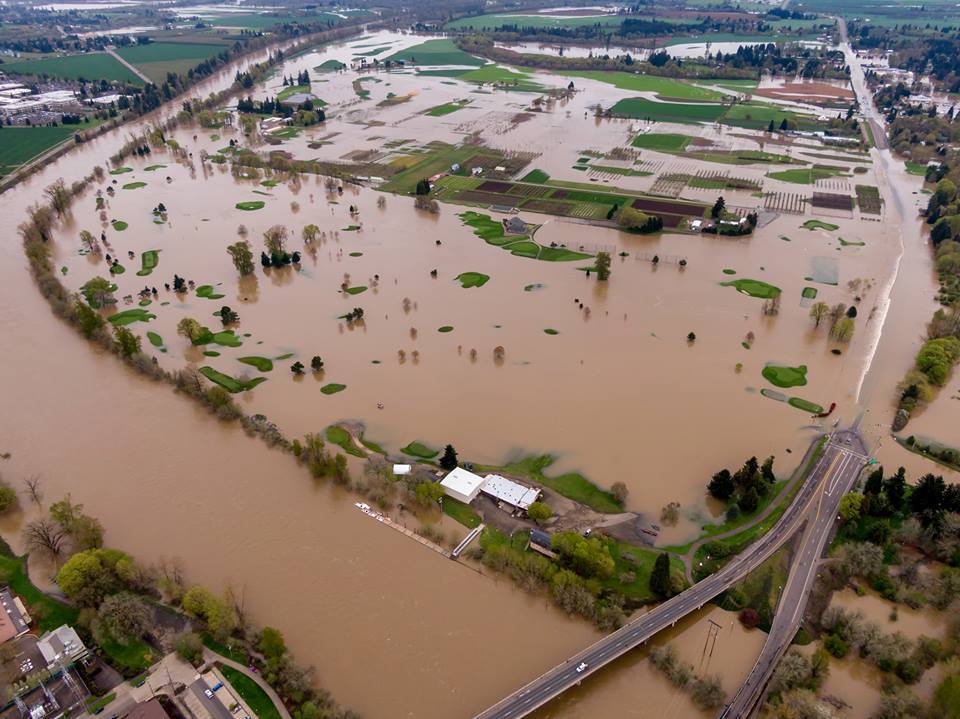
There has been a lot going on lately with the weather and I figured it was past time to get all caught up.  We are looking at one of the wettest Aprils on record, snow in the mountains, and intense flooding across the area.  Flooding in the Willamette Valley has been the worse since January 2012, and in some places all the way back to November 1996!  Right now Salem is 3 inches above normal for rainfall at this point in the month.

This picture was taken on Wednesday.  It shows highway 34 crossing the Willamette River on the eastern edge of Corvallis.  Very high water levels will continue for another day or two.

river flooding 4.10.19

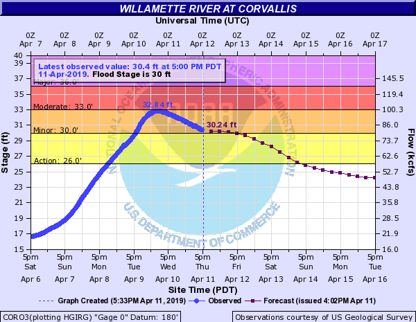
This is a chart of the Willamette’s river level in Corvallis.  It crested at 32.8 feet.  For reference the February ’96 flood crested at 33.5 feet down there.  Pretty incredible!
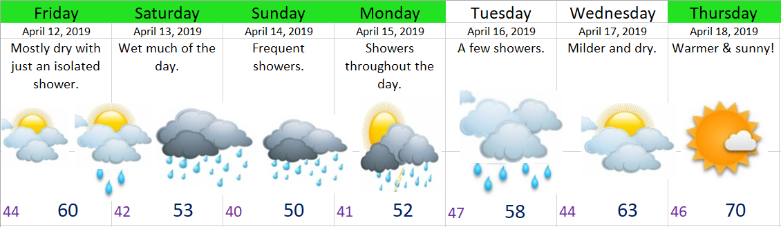
Corvallis river level


Extended Forecast

I’ve got an updated extended forecast here for you as I’m sure you’ve all been struggling through life without one over the past several days 😉

April 11

Details

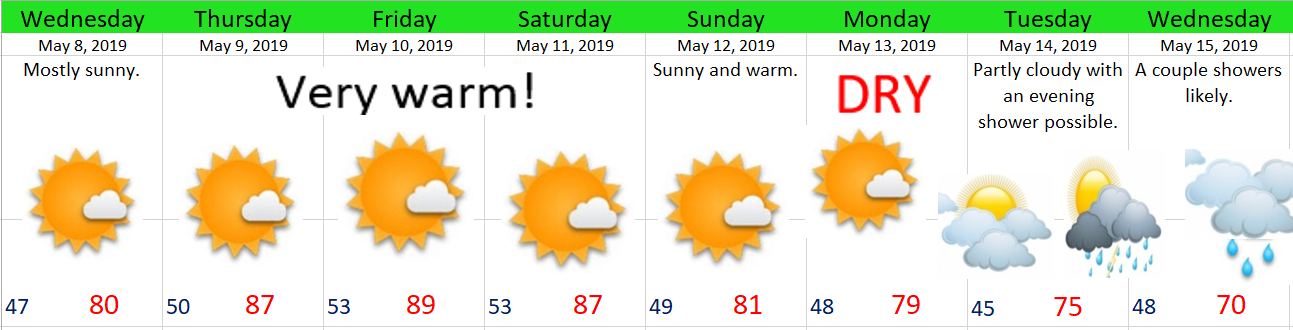
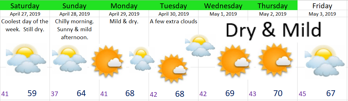
Fairly high confidence with the exception of Tuesday and Wednesday.  Both those days could be wetter or drier than currently forecast.  Right now I’m sorta splitting the difference and banking on Wednesday being a drier day while Tuesday stays on the showery side of things. 

High confidence that we enter into a dry spell stating next Wednesday/Thursday, and there are indications that this dry spell will last through Easter weekend 🙂

In the meantime we have several more cool and showery days ahead.  I’ll leave you with this snowfall map showing a solid 10 to 20 inches of new snow for the Cascades by the end of Tuesday with the highest amounts above 5000′.  Winter is trying hard to hang on. 

mountain snow mid April


Rainy Spring Weather

I’m posting on the go today so forgive me for not having any fancy graphics or nice pictures.  This wet weather pattern is going to continue for the next several days.  Saturday and Sunday look especially wet with localized flooding likely in places.  I’m thinking the valley locations see close to 2 inches of rain now through Sunday night.

Basically lots of rain, plenty of showers, and no completely dry day in sight.  Our rainy spring weather is here to stay, and it’s on that happy and joyous note that I say have a fantastic weekend 😉🌧🌧⛆🌧⛆


One last dry day.

The title may sound rather sad, but that’s just the wet and cloudy reality of this coming week.  After today we head right back into a showery and rainy pattern.

Extended Forecast

March 30.PNG

Highlights & Details

Monday & Tuesday:  Very wet days.

Wednesday & Thursday:  Showers.  More so during the PM hours.

Friday:  Dry start with late day rain.

Saturday:  Frequent showers.


Best shot for some dry time other than today will be Thursday morning and the first half of Friday, and even those aren’t guaranteed.  It’s just that time of year here in western Oregon, but we will make it through.  We always do 😉  Now get out there and enjoy the weather!!