Way above average and the chance for snow

This title refers to both precipitation and temperature. We have had some very mild (mild by January standards) high temps. Two thirds of the way through the month and we are 4.4° above normal!!! Currently we are in one of our top 10 warmest Januarys on record. Yikes!! On the precip side of things it’s been a dry several of days; however, the first 12 days were unusually wet. Salem has had 6.88″ so far which puts us at 157% of normal for this point in the month.

Change is in the air

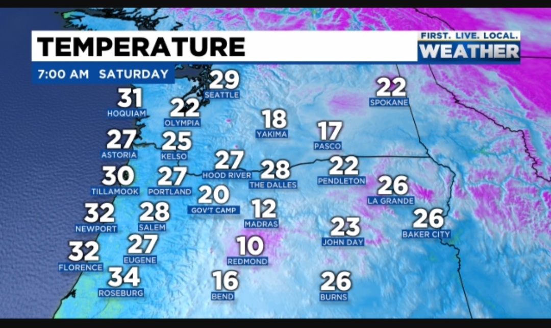
If you were up and outside this morning, then you likely noticed changes in our airmass have already begun to taken place. Check out the chilly morning temps around the region as of 7AM.

We are headed for a much cooler end to January. In fact this past week has already been a little bit cooler; however, even chillier air will work it’s way in over the next few days. Details below:

Highlights

1.) Sunday. Hmmm, I’ve seen and heard lots of rumors about snow this day, but meh, I’m not all that impressed. Unless something changes, I’m going with a very cold rain with snow mixing in at times. It’s possible that it falls as all snow early tomorrow morning for a little while, but it’s going to be extremely difficult for it to accumulate on the valley floor as temperatures are going to likely stay a few degrees above freezing. There’s a better shot at seeing a brief coating of snow 500 to 1000 feet – maybe up to an inch. A few inches of snow are possible above 1000′.

2.) Sunday night/Monday could possibly give a few of us a light dusting of snow if we’re lucky as Monday will be a colder version of our typical sunbreak and shower type of day. Still no chance of any widespread or major accumulation.

3.) Watching Tuesday and Wednesday very closely as a storm will be moving in from a more favorable direction. Favorable at least if you are rooting for valley snow. 😉 We will have cool air already in place and the storm moving in has a bit of cool air with it as well. Of course we need just about everything to line up just right for snow around here, so don’t get too excited yet. At this time, Tuesday is looking like it could be our best shot at sticking snow this entire winter…

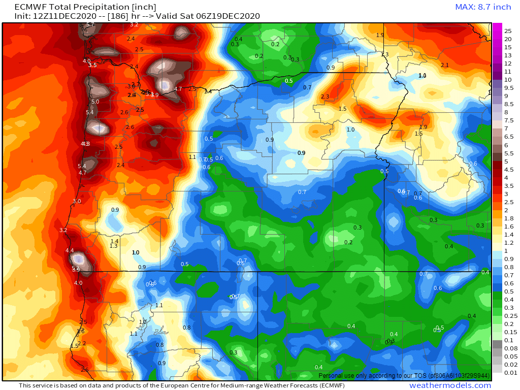
4.) The rest of next week we stay in a very low snow level pattern with lots of snow in the Coast Range, the Cascades, and the foothills around the valley. A very chilly and wet pattern for sure. Great for building the snowpack!

I’ll be updating much more frequently this coming week, so keep an eye out for those and keep an eye out for some snowflakes. 🙂

Take care and stay warm!

Wet

Good and happy Monday morning!!!! 11 days into the month and January is running well above normal in the precip department. We have had several wet storm systems and we have a couple more coming up this week. Take a look at the next 7 days

The heaviest rain will fall during the nighttime hours tonight through tomorrow morning and again the same story Tuesday night. Winds will also be quite gusty Tuesday and Wednesday with gusts 35 to 45mph (maybe a gust to 50 here and there Tuesday night). I suspect 2 – 3 inches fall between now and Wednesday evening here in the valley. This will be a warm rain event, so no snow in the mountains unfortunately.

The only other weather event happening over the next 8 days will be some light rain falling Friday; otherwise, the rest of the next several days should be basically dry and quiet through at least next Monday or Tuesday.

The Coast

The coast should see winds up to 65mph Tuesday and Wednesday along with 3 to 4 inches of rain, and waves topping out 30 to 40 feet! It’s going to be an extremely stormy couple of days at the good ol’ Oregon coast.

There you have it! Watch for localized flooding over the next few days with this heavy rain, and I wouldn’t be shocked if a few people lost power with the wind Tuesday night and Wednesday.

Looking further ahead, it appears as though the second half of January might turn a bit more exciting and maybe a bit cooler too ( a nice little tease hehe), but for now the only highlight worth mentioning are these couple of very wet & windy storms. Take care!!

An early January washout

2021 is starting off on a stormy note. For starters the next 12 to 16 hours are going to be quite windy. Gusts of 35 to 45mph seem likely for the mid Willamette Valley with higher gusts of course along the coast.

The rainfall will be significant over the next few days as well. Nearly 2 inches of rain should fall now through Sunday.

The daylight hours on Sunday will bring a nice but brief break in the rain before more rain moves in Sunday night. Monday’s going to be another soaker with an additional inch of rain falling with that system. For all the visual learners out there (like myself) I have a chart showing these estimated rain totals for now through Tuesday morning.

The main take away is it’s going to be very wet. The rest of the week looks wet too with another storm moving in on Wednesday and I’m watching for the possibility of another storm coming in next Friday or Saturday. An active start to the new year for sure.

THE CASCADES

Lots of snow coming up for the Cascades as shown above. I’m forecasting at least 3 feet for most of the ski resorts by the end of next week – maybe even more.

THE COAST

The final highlight for this coming week will be the very large swells and waves out along the coast. Waves should reach heights of at least 30 (if not higher) every day now through Wednesday. An impressive stretch of large waves out there should you have the opportunity to get away and go storm watch! 🙂

Have a nice weekend and enjoy the stormy weather!!!

Super fast update

I apologize for the lack of updates. It’s been a busy, but fun week with family and friends. We had a chance to enjoy the snow up in the Cascades, and then just yesterday we had the opportunity to travel to the Oregon Coast for the day. Beautiful weather over there yesterday!!

Highlights

1.) Several days ago I mentioned the possibility of low snow levels today. I stated that I wasn’t too excited about anything happening, and sure enough today we have nothing but cloudy skies and some chilly air – nothing more….

2.) Tomorrow will be wet, especially during the afternoon hours with a period of moderate to heavy rain moving in and some gusty winds.

3.) A few showers Thursday

4.) Friday will likely start off mostly dry before rain moves in late in the day.

5.) I should have a more detailed outlook in the next few days, but the main takeaway is that January will be starting off on a very stormy note with several rounds of strong winds, lots of rain, and copious amounts of mountain snow beginning Saturday and lasting through the at least the first 9 days of the month. Check out the estimated total precip for now through Saturday January 9th. 4 to 5 inches of rain for the Mid-Willamette Valley with up to 10 inches in the Coast Range! Much of this is expected to fall as snow up in the Cascades. We are looking at maybe several feet of new snow next week for the ski resorts. Busy and wild times are coming!!!

Christmas 2020

It’s Christmas Eve! I hope you all are doing very well!! It’s freezing cold outside. As of 2PM it was still only 32 degrees here in Salem!!!!! Tonight will be cold as well with temps falling back into the upper 20s across the valley.

Highlights for the coming week

1.) Christmas day is going to be cold with a drippy/wet afternoon. Not cold enough for snow (or ice) this time – just a cold light rain for us here in the valley. Watch for spots of ice due to the freezing fog tonight and Christmas morning as temps will be below freezing again. Temps SHOULD rise above freezing just before the rain starts tomorrow, so at this time I’m NOT expecting any freezing rain issues.

2.) The Gorge should see snow both tomorrow and again on Saturday, so take note of that if you need to head over I-84.

3.) Saturday will be rainy at times and breezy with several inches of mountain snow.

4.) Sunday should be mostly dry. Monday will totally dry, but quite cold.

5.) Another storm comes in Tuesday of next week. Don’t get too excited, but I’m keeping an eye on this one as snow levels could start out fairly low as this storm system moves in before we warm up. Again, not too excited about anything yet, but I will be watching for any changes with this storm and I should have an update for you all either Saturday or Sunday.

There you have it! Merry Christmas and have a wonderful time celebrating!!!!

December 18th

It’s been a busy week between work, Christmas shopping and a few family events. As promised in my last forecast, things have turned wetter over the past several days and the wet weather should continue for several more…

The biggest highlight is probably the rainfall we are expected to receive Saturday through Monday. This chart shows Salem receiving just over 3 inches between now and Monday night!

Saturday night and Sunday will be the wettest period with lots of steady, and at times heavy rain. This will also be the time to watch for some minor flooding. There’s currently a flood watch up for our region. I suspect the flooding will be contained to smaller creeks and streams and some of the more “typical” low laying areas, but keep an eye out just in case. Here’s what the next 7 days look like.

Highlights

1.) If you have to get things done outside then Saturday is your best bet with a few dry breaks during the day before the steady rain moves in Saturday night.

2.) Chilly air moving in will change our warm rain into a cold rain during the day on Monday. In fact, our high temp will likely be during the morning hours as we gradually cool through the day. By Monday night the snow levels will be down into the foothills and the Coast Range.

3.) Cold and dry leading up to Christmas.

4.) A chilly rain Christmas day. Yeah, that’s not real exciting, but unless it can somehow be colder than what is currently being predicted, I just don’t see anything other than a cold rain that day.

The Cascades

The Cascades will see rain for the majority of this incoming system; however, Christmas skiing will be saved thanks to the cold air arriving on the backside of this storm. 6 to 12 inches of new snow should fall Monday through Tuesday. More snow should fall late in the day on Christmas as well as the day after making for some excellent Christmas break skiing!!! Hoodoo currently has 41 inches at its base which is not too shabby for this time of year.

Take care and stay safe!!

December 11th

We’ve kicked off December on a rather dry note. 10 days in the bag and we have only received 20% of our usual rainfall. A very dry start to the month!! Of course these things tend to balance out, and sure enough the next couple of weeks look wet with lots of Cascade snow and plenty of valley rain.

Highlights

1.) This map shows about 2 to 3 inches of rain through Friday of next week with rain almost every single day.

2.) Both Saturday and Monday will be the only mostly dry times over the next 10 days. Keep this in mind if you’re wanting to do stuff outdoors.

3.) No big wind storms, flooding, snow or ice on our horizon; although there will be some snow and ice in the Gorge at times on Saturday night and Sunday morning should your travel plans take you out there – specifically east near Hood River and The Dalles.

4.) Large swells/waves are forecasted along the coast beginning on Sunday and lasting through at least the middle of next week. You can also expect gusty winds out at the coast with the storms coming in this week.

5.) Up in the Cascades 20 – 30″ of new snow now through next Friday! Best travel days will be Saturday and Monday as they will be drier. Thursday & Friday will be somewhat decent travel days in that there will be rain, not snow falling up in the passes. This also means Thursday & Friday may not be the best time to go skiing (unless you enjoy skiing in the rain lol). Nice to see that overall the snowpack will continue to grow this week.

There you have it. Fairly typical stormy December weather with rain down here and lots of mountain snow.

Take care and stay safe and healthy!!