Extremely mild and November 2021 recap

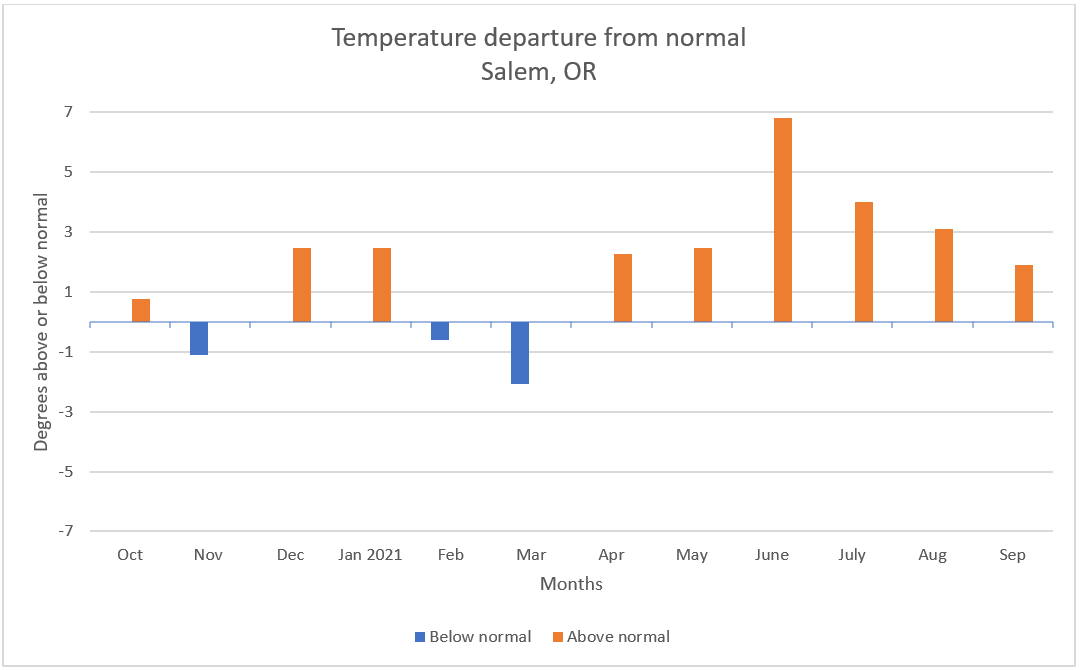
The second half of October and the first half of November were both quite stormy and active with several small to moderate wind events, plenty of rain, and mountain snow. Since then it has basically been a blowtorch around here. November 2021 ended up being 3.5° above normal which is fairly significant. We still managed to dip below freezing once on the 21st with a low of 30°, but overall it was quite mild with 9 days reaching at least 60°! In the precip category we came up a little bit short despite the very rainy and wet start to the month. 5.50″ was our grand total for the month which is 92% of the monthly average.

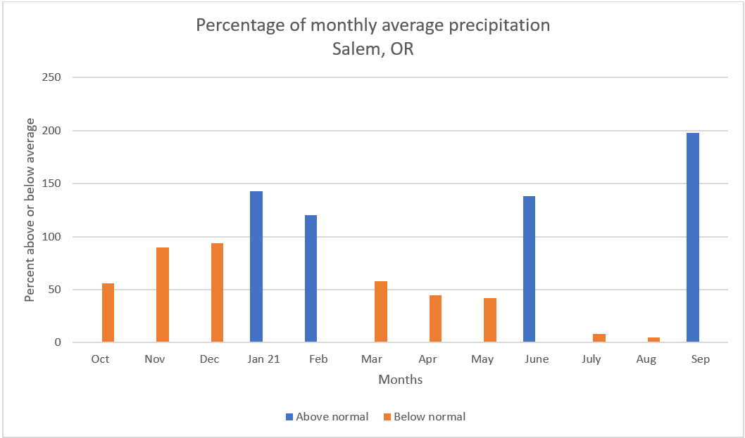
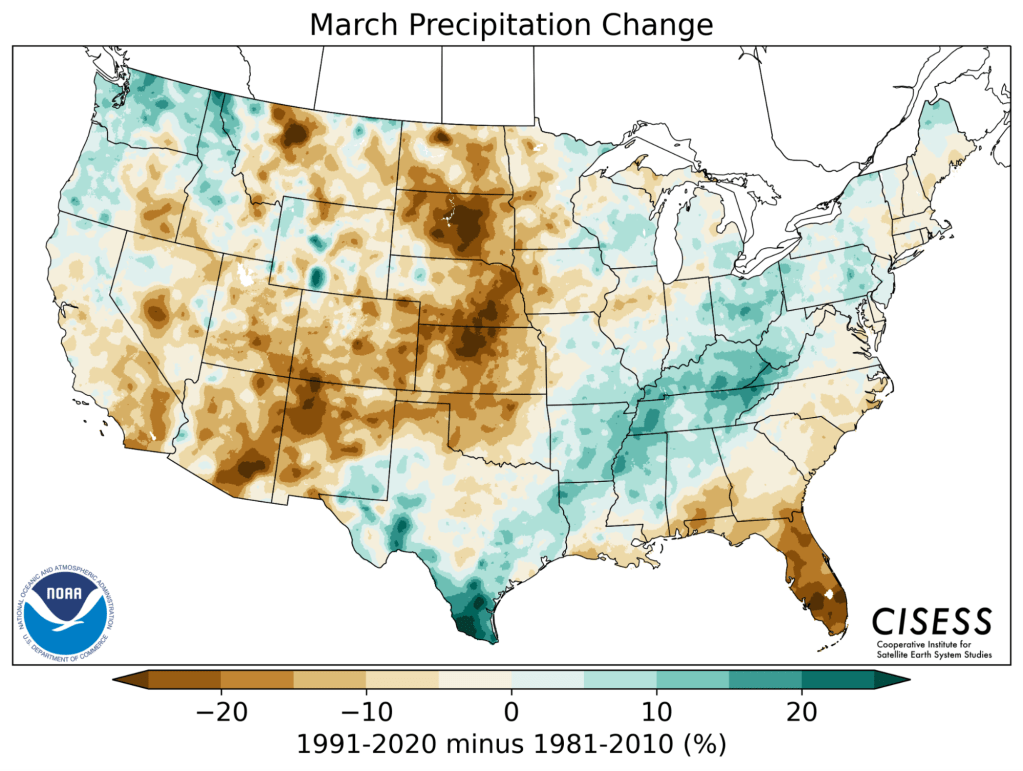
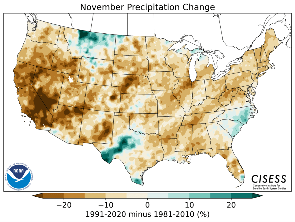
November is actually one of the months which became slightly drier when the new averages were updated this past year. Between 1980 and 2010 the normal rainfall for Salem during the month of November was 6.5″. When the 1980s were dropped and the 2010s were added, our average rainfall for November dropped by a little more than half an inch down to 5.95″. Meanwhile, both March and October have turned wetter over the past decade. Interesting don’t you think? The maps below show the changes in average precip for each of these months.

Total Salem rainfall for November going back to 1990.

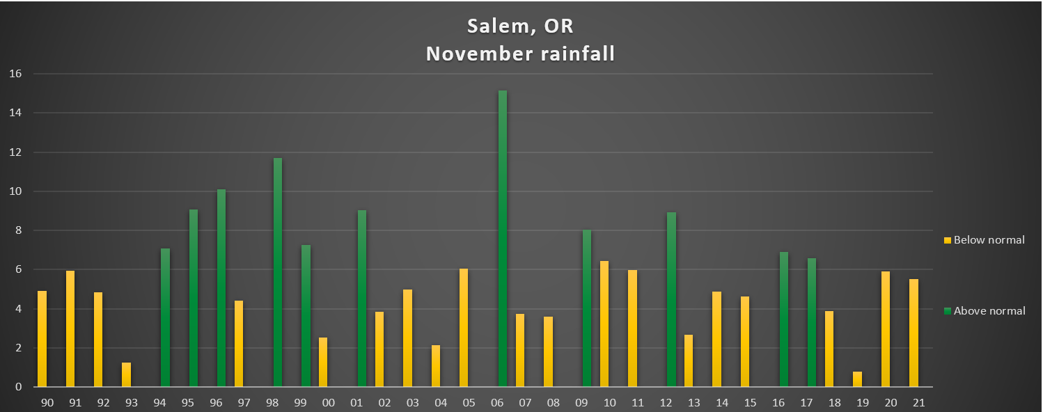
1995, 1999, 2008, and 2016 all had really mild Novembers as well with temps very similar to what we have seen this year. All 4 of these years were also La Nina winters, and 3 of the 4 years listed ended up delivering at least one good snowstorm here in Salem. I’m sure some of you remember all the snow we had before Christmas in 2008, and then the winter of 2016/2017 had several snow events too, so a warm November does not at all mean a warm winter. It doesn’t guarantee a cold one either, but don’t be too worried about the lack of cold or mountain snow just yet. In fact weather maps are indicating this may be the last week of mild weather for quite some time, so get out there and enjoy it! 🙂

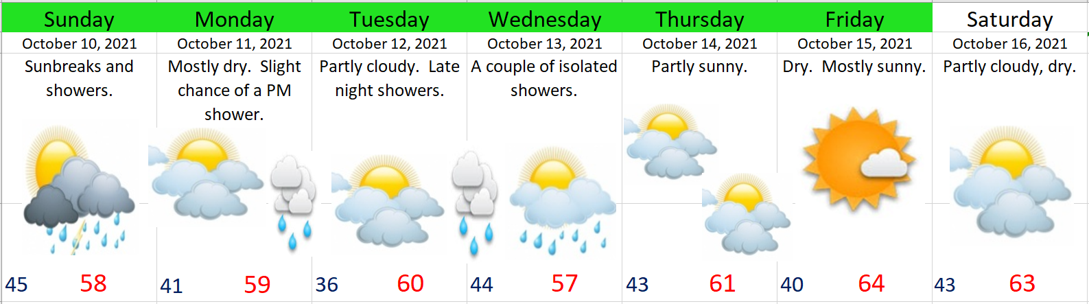
Quick forecast and look ahead

1.) Mild weather continues through Sunday; although today will likely be the last 60 degree day – finally…

2.) A few sprinkles are possible both Thursday and Saturday, but honestly it won’t amount to hardly anything.

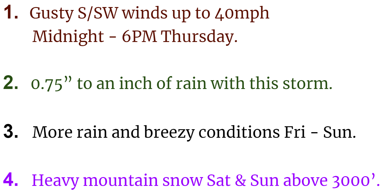
3.) The nice weather ends Monday as a significant storm system rolls in bringing a good amount of rain. This storm will be the first of several storms bringing multiple rounds of showers, rain, and mountain snow for the rest of next week.

Wet November and stormy Monday

I know I’m at risk of losing popularity for saying this, but I have really enjoyed the rainy weather this fall. We were due for a really wet November. Saturday was the first totally dry day we have had this month. Hard to say if the second half of the month will be equally wet, but we are definitely on the “right track” for a wetter than average November. Here’s the extended forecast. Notice it’s not nearly as damp as what we saw last week.

Highlights and details

Monday is going to be a stormy day. A very potent cold front moves in Monday. This front will be a fairly strong with gusty south winds ahead of it. Gusts will range from 30 to 40mph. Expect a few hours of steady rain – some of which will be quite heavy and could lead to some isolated street flooding where drains are clogged. A sharp drop in temperature will follow behind the front as winds shift to the west northwest. Snow levels will drop from over 7000′ down to 3000′ Monday night; however, only a few inches of snow is expected in the passes as most of the precip with this storm will be fall on the warm side of the front.

Then we have a two day stretch of cool, sunny, and dry weather. Could end up with a bit of stubborn fog here in the valley, but it will definitely be dry and the mountains and coast should be very nice and sunny!

I’m keeping a close eye on Thursday and Friday as another dynamic storm moves across the state. This one could bring another round of very gusty winds to the region along with mountain snow.

Have a great week!!

Soaking rains

November 2021 is running well above normal in the precipitation department with a little over 2 inches of rain so far this month. Definitely a La Nina feel out there lately. The mountains also picked up a solid foot of snow over the weekend, and now we are looking at what will be the rainiest couple of days we have seen this fall. Take a look at the estimated rainfall for now through Saturday morning.

Moderate to heavy rain moves in overnight. By the time you wake up Thursday morning, over an inch of rain will likely have fallen with almost another inch expected during the day on Thursday through Friday night. This storm is ushering in very mild weather which means rain even up in the mountains. There is also a chance of thunderstorms with the rain tonight. It’s going to be one of those stormy nights.

All this rain plus the melting of our mini snowpack in the Cascades will lead to some flooding. We are under a flood watch and I suspect there will be some minor to moderate flooding along some of our low laying areas, creeks, and streams.

I don’t expect major flooding and I don’t expect any flooding on the large rivers like the Willamette.

The rain shuts off Friday night fairly quickly leaving Saturday and most of Sunday dry. Some showers might sneak in Sunday late in the day. If you have plans this weekend the good news is you should have some decent weather to go with them.

Another storm system rolls in on Monday bringing more rain, cooler air, and mountain snow.

There you have it. Stormy with no big dry stretch in sight. Stay safe and watch for flooding.

Stormy fall weather

We have a nice fall like storm approaching our coastline tonight, and an overall very active and exciting weather pattern shaping up for the next several days. Here’s a satellite image from late this afternoon showing the looming storm.

Impacts here in the mid Willamette Valley

Below is an estimated radar image for around noon tomorrow showing the heavy showers expected on Thursday.

EXTENDED FORECAST

Thursday: Quite stormy with the gusty winds and numerous showers.

Friday: Showers. Dry and maybe even partly sunny near the end of the day. Will cool off quickly once the sun goes down.

Saturday: Much cooler with steady rainfall. Breezy afternoon.

Monday: This day could end up being mostly dry.

Tuesday: More rain and wind arrives and will likely last through Wed also.

I’ve got a nice little October recap in the works. Looks to stay active for awhile, so anticipate more updates in the coming days.

Take care, be extra kind, and stay safe!!

Stormy day

By every definition of the word today is going to be a very stormy day.

By the way, you may have heard by now about our “bomb” cyclone/storm offshore. I can tell you that yes, this is one of the strongest storms on record this close to our coastline; however, it’s 100s of miles away and the winds from it will be nothing more than what we see with a typical wintertime storm. With that said, we still have a lot of very stormy weather on tap for today.

Highlights

1.) Winds will gust 30 to 40mph today and tonight which is still enough to cause a few scattered power outages.

2.) Showers have the potential to be very heavy with this storm. I expect some neighborhoods will see ponding on roads and maybe some spots of brief localized flooding especially where drains are clogged. Some low laying areas could be at risk if a heavy shower stalls overhead. This type of weather pattern is conducive to showers stalling over the same locations leading to heavy rainfall totals in localized spots.

3.) The coast will see some massive waves today. Waves up to 40 some feet are possible through tonight.

4.) The coast is also at risk of seeing some weak funnel clouds and or tornados. Not trying to frighten anyone, and if any do form they will likely be the typical weak NW variety. Regardless, even a weak tornado can still cause damage.

5.) Anyone could hear thunder as the atmosphere is very unstable today.

Monday will be similar as this storm system takes its time moving across the region.

Stay safe and enjoy the stormy fall weather.

Stormy week ahead

I have a fun new chart to show you all. This chart below is really good at conveying the big picture up to two weeks out with each horizontal line showing a single possible outcome. Time on this chart goes from left to right and it shows 24 hour rainfall totals (measured in inches) ending every 12 hours which means there is some overlap with these totals.

What I look for on charts like this one are patterns and trends – not details. So in this case the concentrated number of predictions showing heavier rainfall around the 22nd and again near the 28th of October provide me with a high level of confidence some sort of big rainstorm is heading our way both those days. Another use of these maps is just looking at the probability for rainfall on any given day. For example, from looking at all of these possible outcomes, it seems extremely clear to me that today will be the last completely dry day until at least the 30th with many of the predictions showing rainfall every single day for the next 11 days.

We are heading into a very stormy and wet weather pattern. Right in line with what we would expect during a La Nina. Between now and the end of the month we could easily see over 5 inches of rain! Check out this total rainfall map ending close to midnight on Oct 31st.

Again, the message seems very clear to me which is very wet times are heading our way. Here’s a satellite image of tomorrow’s storm heading our way.

Highlights

Two other things to really watch for with these storms are: number one, the high surf and big waves at the coast. These storms are capable of producing some really big waves. Great for storm watching, but be careful if you head out there.

The other concern I have is for high winds and the increased potential for power outages in the coming days as strong winds develop with some of these storm systems. In fact, we could see fairly gusty winds Wednesday with this first storm system. Winds will likely gust 30 to maybe 40mph tomorrow morning. Nothing too crazy is being predicted for the moment, but this pattern will bring the windiest weather we have seen since January.

We also have a chance for a few thunderstorms Wednesday.

Thursday will start out mostly or even completely dry and could stay dry until the late afternoon before the next storm rolls in.

Expect both the weekend and much of next week to be stormy and quite wet.

Stay safe!

September 2021 and a quick forecast

I figured it was time to bring back the monthly reports. These are definitely a fun way of documenting the month just in general as well as highlighting any major weather events from the month. If you are looking for the forecast then skip down to the bottom. 😉

September 2021 Summary

Much of September 2021 was actually very warm and summer like which is common for September; however, a few good soakings during the second half of the month gave Salem a rainfall total of 2.89″ which is a whopping 198% of our monthly average! This chart below shows the percentage of total precip for each month here in Salem going back to last October.

This image above shows the upper level pattern which brought Salem steady rain on the 27th.

At 1.9° above normal, September ended up being Salem’s 6th warmer than average month in a row in what has been a fairly warm year. This chart shows the number of degrees above or below normal each month has been since last October.

Looking ahead

October is off to a fairly cool and dry start. As of today (Saturday), Salem is sitting at 3.7°F below normal for the month, but with only .19″ of rain. From looking at the long range charts, it seems obvious the cooler weather is here to stay.

FORECAST HIGHLIGHTS

1.) Sunday’s going to be a typical shower and sunbreak type of day with small hail and brief downpours possible. Very cool air with this storm will bring a few inches of snow to the Cascades Sun night and Monday morning.

2.) Plan on Monday being mostly dry with just a very slight chance of a PM shower. The cool airmass behind this system will set us up for our coldest lows of the year Tuesday morning with frost in some of the outlying areas around the valley.

3.) A weak storm system moves though Tuesday night and Wednesday bringing a few showers here and there, but nothing big.

4.) Besides the nice weather we are seeing today, next Tue, Thu, Fri, and Sat all look dry for outdoor projects and adventures. No sign of any late season warmth to go with that dry weather unfortunately as we seem to be locked into a cooler pattern for the foreseeable future.

There you have it. Have a fantastic weekend!