
Our very mild and tranquil winter is finally shifting gears with a much colder week on tap, and at times wetter, and possibly whiter too. Yes, for the first time this entire winter season I’m thinking the Willamette Valley has a shot as seeing at least snow in the air, and maybe something more exciting.
Highlights
From Monday night through Friday we will be in a very chilly pattern with showers and occasional sunbreaks. Random more organized waves of precip will also move through from time to time.
This is not a major snowstorm setup where we can know days ahead of time that it will be snowy or icy, nor will this be a deep freeze setup. This is a play it by ear type of pattern where if all the ingredients line up at the right time we could see a few slushy inches of snow here in the lowest parts of the valley.
Any snow that does fall would melt by late morning or by noon. Impacts would primarily be limited to the late night and early morning hours only.
Locations with any extra elevation (higher hills west and south of Salem, Waldo Hills east of Salem, etc.) will most certainly stand a higher chance at seeing some snow this week. The foothills, the Coast Range, and the Cascades will all score well too – finally! I have a Cascade forecast near the bottom of this post.
Details
Monday: A chilly rain. High of 46°. Turning to showers Monday night.
Tuesday: Morning low of 34°. This will be our first shot at seeing snow both in the air flying around, and possibly sticking. Too soon to know details. I foresee more updates as each of these events draws closer. The afternoon will consist of showers, sunbreaks, and a few hefty downpours. Hail and graupel are very likely almost every day this week as cold air aloft moves overhead. High of 45°.
Wednesday: Day two of our dance/flirt with snow. Morning low of 32°, and a high of 44°. More afternoon showers and sunbreaks.
Thursday: As of right now, this day stands to be our best opportunity for accumulating snowfall down to the valley floor. A low of 31° and a high of only 42° as a more organized band of precipitation crosses the Willamette Valley Thursday morning. At the same time, the airmass will be pretty cold. Too soon to get excited, but at a minimum, it will be another chilly day with showers and some small hail or graupel.
Friday: Rinse and repeat. Low of 31° and high of 43° with more very chilly showers.
Saturday: The trend for Saturday is for a mostly or even completely dry start with increasing rain late in the day. AM low of 32° and high of 45°.
Sunday: Rainy at times. Highs in the mid to upper 40s.
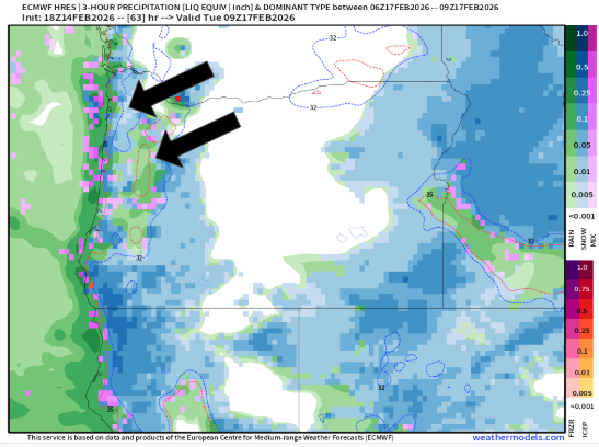
How about a few images to illustrate what we might be seeing? This first image is for Tuesday morning. I’ve pointed out the snow in the Coast Range (blue), and the rain in the middle of the Willamette Valley (green). I also see a few spots of blue and pink across the valley indicating a very close call with snow that morning.
Then scattered snow showers in the area come Wednesday morning. Please note that snow in the air or on this map does not equal accumulating snow. I’ve noticed this particular weather model likes to produce snowfall with temperatures up to about 37° which is way too “warm” for snow to stick, but you get the idea.
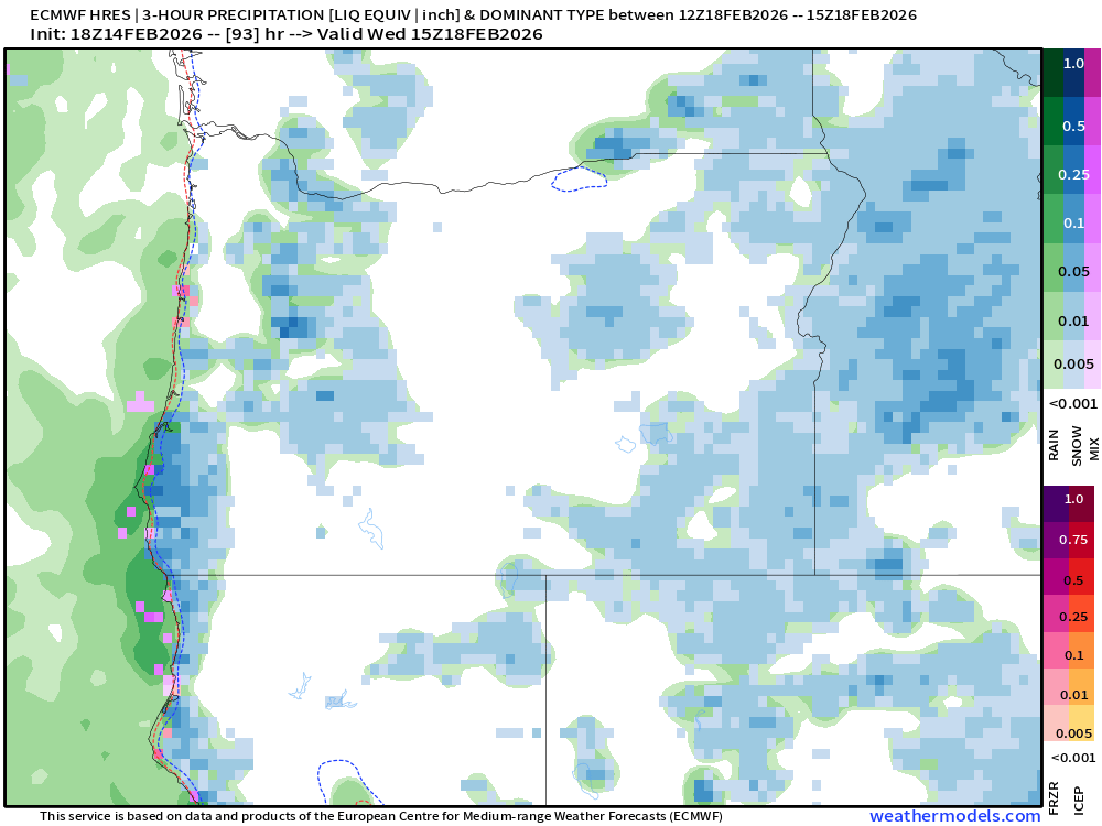
And lastly, Thursday morning. You’ll notice more widespread blue over the valley. This model and other forecasting models have been insisting on a steady batch of precip Thursday morning (similar to what’s pictured below). This could give anyone some slushy snow regardless of elevation.

Main message is that we will be very close to seeing snow any of those three mornings. Honestly, Friday morning too. So four days in a row with a chance for some wet snow. Typically in this weather pattern we can identify snow chances with higher accuracy about 24 to 48 hours in advance.
The Cascades
It’s unfortunate that the snowfall this past week was not enough to reopen Hoodoo and Willamette Pass. That sucks to miss out on such a big weekend. The best news I can offer is snow ramps up again over the next several days, and openings next weekend (20th – 22nd) seem much more likely. Snowfall totals through Friday should be at least between 10 and 18 inches at pass level, with potential for a little more. Hoodoo currently has 17 inches at their base. Hoping this can be enough for them to open. Additional snow falls next Sunday.
As always, stay safe, and have a great rest of your weekend!
