
A really nice day today, in fact, the second great day in a row here! Water levels are going down now (even on the slower responding rivers), but standing water may persist in many of these low laying areas, rural locations, and some of our local parks. There is just too much water and the ground is not able to soak it all up at this point. Be sure to check ODOT, and park websites to check for road closures, State Park closures, and well, closures in general. There are a lot of roads, highways, and parks still closed for the foreseeable future, and it would be prudent to check before making plans.
Link for ODOT travel conditions here: https://www.tripcheck.com/
Use this link to check the status of State Parks. Just type in the name of the park you wish to inquire about and (hopefully) up to date info will appear: Oregon State Parks
I’m watching one storm for Christmas Eve that could cause some gusty winds, especially up in the mountains and over in central Oregon. Besides that storm, the weather looks pretty calm through Sunday the 28th. This gives us a nice window to travel and enjoy Christmas without weather impacting us too much.
Extended forecast

Details
Now through Tuesday is pretty straight forward. There is a chance for a shower at almost any given time over the course of these four days, but there will also be plenty of dry breaks in between (like we are seeing right now). The wettest timeframes look to be late Sunday afternoon, and Monday.
Wet and breezy on Wednesday, but nothing too strong in our area. The strongest winds will take place in the Cascades, central Oregon, Wallowa mountains, and the Siskiyou Pass heading down towards Shasta. Because Christmas Eve is such a big travel day, I think it’s worth keeping an eye on this forecast. I did a little sketch to highlight these areas for you all. I’m clearly not an artist lol. The numbers you see on here are estimated max wind gusts in knots.
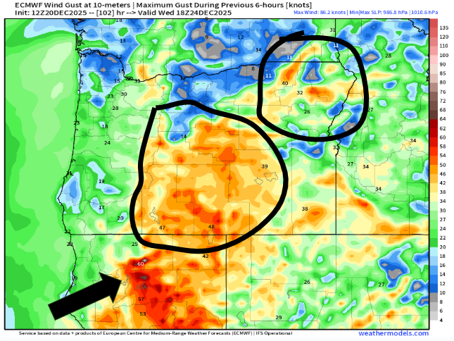
The potential exists for some really gusty winds in the highlighted areas early Wednesday morning/early afternoon, and if you plan to travel to or through any of these areas on during this time, then keep a close eye on the forecast. I will have another update Monday morning highlighting any changes to this forecast.
Once we get past the wind event Wednesday, travel conditions look pretty great through Sunday the 28th.
The Cascades
Mountain snow slowly accumulates in the coming days with a few inches here, and a few inches there adding up to a little over a foot of new snow through Christmas Day. Not great, but it’s a start.
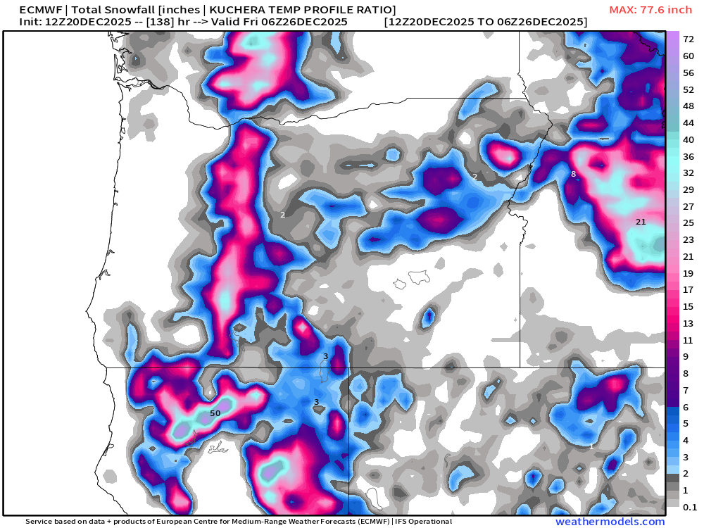
The final days of 2025 look to be on the cooler side with additional storms bringing valley rain and mountain snow. If resorts are not able to open by Christmas or the day after, then I think they will be able to by New Year’s Eve as we stay on the cooler side of the jet stream. Let’s hope that stays the case!
Have a fantastic weekend and enjoy the beautiful weather as it presents itself! 🙂
