
For many of us, today’s regular schedule was disrupted due to the aftermath of last night’s windstorm. Lots of delayed and even closed schools, PGE and Salem Electric together reported thousands power outages very early this morning, and plenty of blown over fences, trees, and debris in the roadways. I had no trouble finding evidence of the storm while out and about today. Unfortunately, the weather is going to hit us hard again tomorrow.
Details
Thursday
The forecast really has not changed at all. Expect steady, heavy rain to fall the majority of the day. Most valley locations from Eugene through Vancouver Washington will pick up close to two inches of rain, and some valley locations could get over three inches of rain with just this one storm. Yes, this will be a top tier rainstorm for some of us. It all depends on where the very heaviest rain tracks; regardless, everyone gets a major soaking which will bring creeks, streams, and rivers back up. Rule of thumb, if you had high water with last week’s rainstorm, then expect just as high or higher water levels with this incoming storm. The map below depicts the expected rainfall totals through Friday morning.
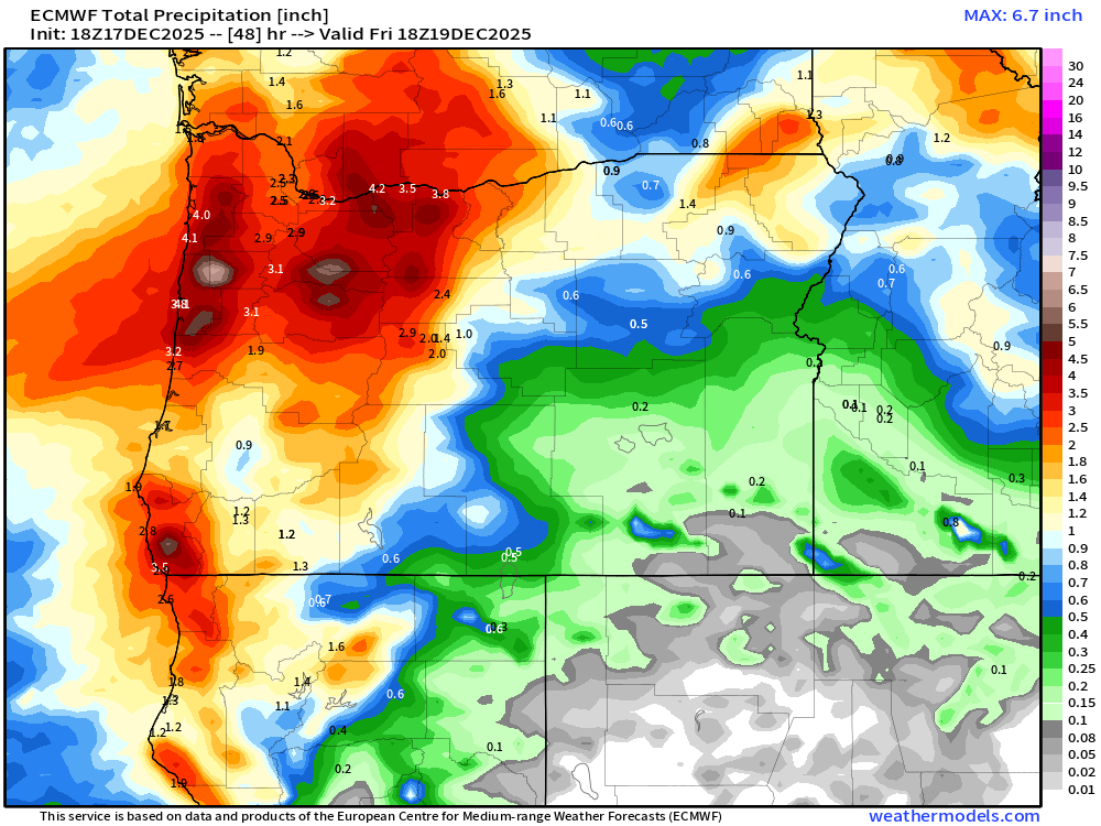
Foothill locations and the mountains should get between 4 and 7 inches of rain. Some of that rain will melt the fresh snow that fell today adding to the flooding concerns.
There is a Flood Watch posted which covers all of western Oregon, and instead of naming all the rivers that could flood, I’ll just leave you with this graphic. If you live in the green highlighted area, and you live in a historically flood prone area, then you should pay attention and prepare for high water levels.

You can also find out river level forecasts from this link here: River level forecasts. Just keep in mind that these river forecasts change (up and down) frequently, and are meant to give you a general idea. The South Yamhill, Pudding, and Luckiamute rivers are three specific rivers expected to approach moderate flood stage levels.
Stronger wind gusts make a return appearance on Thursday as well. Widespread gusts of 35 to 45mph for the Willamette Valley, and gusts up to 55mph in the mountains and along the coast. A little weaker than the winds we saw last night, but these wind gusts could go on for a longer period of time. Add in the heavy rain, saturated soils, and we will certainly see additional power outages and downed trees. Winds peak in the very middle of the day (11AM to 3PM) before subsiding. Heavy rain will continue through Thursday night even after the winds die down.
Friday – Tuesday
Regular Oregon weather is expected. Showers each day, sunbreaks at times, a few downpours here and there, periods of rain (especially Sunday and Monday evenings), and breezy winds from time to time, but nothing too wild. Highs in the mid to upper 40s. Snow is going to really start to pile up in the Cascades too. Snow totals from Friday through next Tuesday will range between two and three feet of new snow. Finally some good snowpack, and perhaps, enough snow for ski resorts to open up for the season.
Here’s a link to the Discord page if you wish to pop on there. The plan is to share weather related photos on there as well as short updates to the forecast: I also found out that you can join Discord on your web browser without having the app. Link is here if interested: Bryan Weather Alerts on Discord
Hoping you all can relax this evening before the weather beats us up again. Stay safe out there!
