
Sometimes I think to myself “Do I overuse this phrase?” My answer was “maybe,” and maybe I need a specific criteria for using the word “wild” in forecast titles. Regardless, I think the upcoming weather qualifies as “wild” lol. Highlights are here with details further below.
- Expect some very heavy rain and strong gusty winds tonight. Wind gusts up to 50mph.
- Scattered power outages possible anywhere in western Oregon tonight.
- Slight chance for thunderstorms tonight through mid day Wednesday.
- Strong winds return on Thursday.
- Very heavy rain all day Thursday through Friday morning – 2 to 4 inches.
- Flooding Thursday and Friday – on a slightly larger scale than we saw last week.
Details
Tonight
Wind gusts will range between 45 to 50mph. This will match or exceed the strongest gusts we have had so far this season. Wind gusts are never uniform across the whole valley, but most of us can expect something close to that range. This is a very dynamic cold front moving through, and the warm moist airmass currently in place will help fuel these strong winds. As the front passes over the valley, temperatures drop 12 to 15 degrees just within a couple of hours. Bursts of very heavy rain are also expected tonight. This storm will mostly take place while we are sleeping (9PM to 4AM, but don’t be surprised if the weather wakes you up tonight.
Power outages and downed trees usually over perform whenever we have saturated soils. Be prepared for scattered power outages tonight and lasting through at least the morning hours.
Thursday’s rainstorm
Here in Oregon, this will be more impactful than last week’s rainstorm. Confidence is growing that steady rain will begin early Thursday morning, and lasts through the first part of Friday before switching over to a few afternoon showers. Rainfall rates look impressive. This map shows rainfall totals between now and Sunday morning.
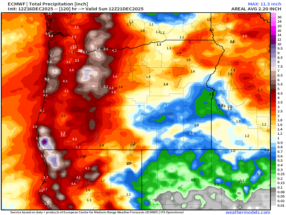
Rain totals like these will cause at least some flooding. I’ve attached water level forecasts of four area rivers, and in all four cases you can see river levels are expected to go higher than what we saw last week. This tells me flooding could impact a higher percentage of us by the end of the week. Click on each image for a closer look.

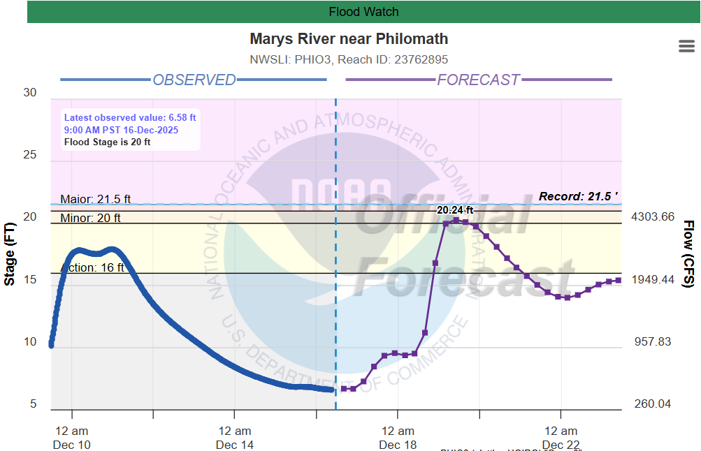
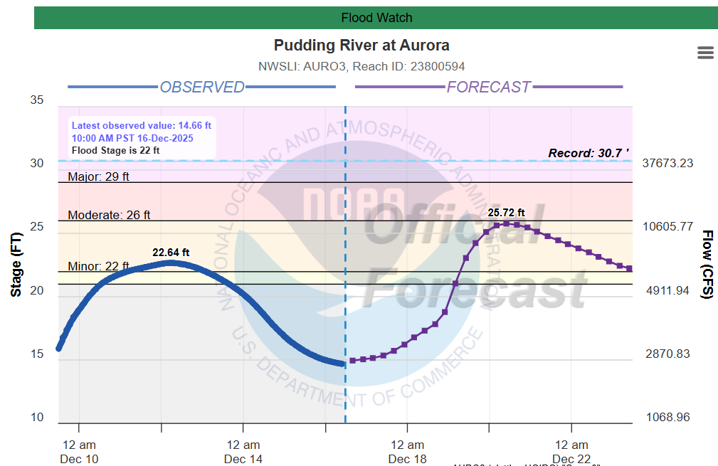

The Willamette in particular is expected to be significantly higher than it was last week. Something to watch. Winds also pick back up in intensity on Thursday giving us another threat for additional scattered power outages.
Friday afternoon – Monday
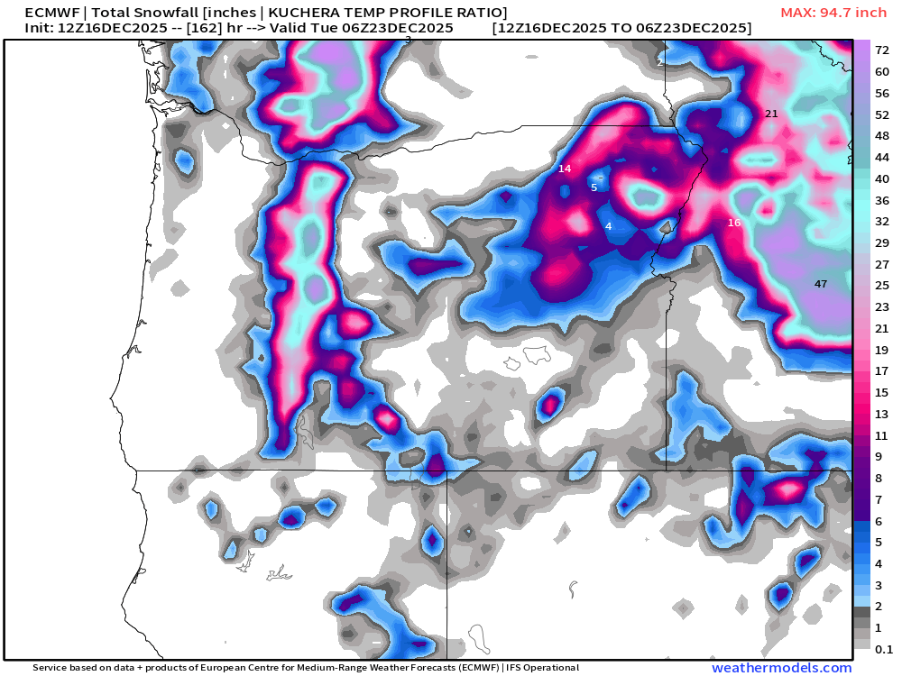
This will be a cooler stretch of days with highs here in the valley around the upper 40s. As of right now, no big storms during this timeframe, but a cool, onshore flow will keep showers going in the lowlands, and snow up in the mountains. In fact, it should be a pretty good mountain snow pattern. Totals through Monday night shows the Oregon Cascades picking up a few feet of snow. Maybe there will be skiing in time for Christmas after all. Chains or traction tires will either be recommended or required going through the passes Fri – Mon.
Bryan Weather Alerts on Discord
Take care, and stay safe out there!
