
Short version
Three very wet, and windy storm systems are lined up for this coming week. The stormiest time frames with steady rain and gusty winds will be:
- Monday
- Tuesday night and Wednesday morning
- All day Thursday through Friday morning
Remember you can join Bryan Weather Alerts on Discord too. Discord is a great platform (without all the junk or distractions Facebook and Instagram have lol), and works very well for posting quick updates to the forecast, especially when there is a lot of action going on. It’s also a great place to easily share weather related photos. Bryan Weather Alerts on Discord
Recap of warm week and look ahead
In all reality, other than Monday and Tuesday, this past week has been quite pleasant. We had some really, Really warm weather earlier in the week. Salem had back to back days with high temperatures of 62°. Believe it or not, neither 62° high was a new record. Way back in 1929, Salem recorded balmy 70 and 71 degree highs for those two dates. Of course, as soon as the warm southerly winds died down, the fog and low clouds moved right in, and we have been stuck in them ever since.
We have three separate storms coming up for this week, and all of them will bring steady rain and gusty winds. By this time next weekend, I expect at least another 3 inches of rain here. There is still uncertainty about flooding for this Thursday and Friday, but I’m watching it closely, and you should also be watching for future updates as time gets closer. 🙂
Extended forecast

Details
Monday: Our first real rainy day of the week. Breezy at times, but mild. I’m thinking gusts around 30mph give or take, and rainfall totals around half an inch.
Tuesday evening & Wednesday: This storm will pack a quite a punch. A very strong cold front moves in late Tuesday evening bringing very gusty winds along with heavy rain. Rain totals half an inch to an inch, and wind gusts Tuesday night into Wednesday morning will range from from 40 to nearly 50mph. Rain lets up dramatically Wednesday morning transitioning into a few showers. Some sunbreaks are even likely during the afternoon hours between showers.
Thursday & Friday: Steady rain all day Thursday continues all the way through Friday morning. 24 rainfall totals are expected to be well over an inch with this system. I’m watching this one closely in case rainfall totals trend up any higher. At least some localized flooding is possible with such hefty totals.
Coast
Strong winds are forecasted for Monday, Tuesday afternoon through Wednesday morning, and again on Thursday. Gusts 45 to 55mph with all three storms. The coast is much more accustomed to such conditions, but the back to back nature of these storms over several days will lead to a few downed trees and isolated power outages over the coming week in coastal communities. Surf will generally be running high as well. Watching for coastal flooding and river flooding – especially during Thursday & Friday.
Cascades
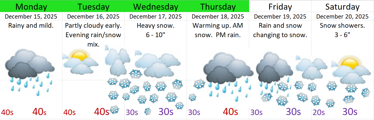
Great news for the snowpack and ski resorts. We finally start building up some mountain snow this week.
- A pretty good dumping of snow is expected Wednesday.
- More snow will fall Thursday morning.
- Additional snowfall is expected on the cooler backside of Friday’s storm, and should last right through next weekend.
Here’s a general forecast for the major Cascade passes. I’ve never done one of these graphics for the mountains, but I thought it could be useful. I figure this is good for Government Camp, McKenzie–Santiam Pass, and Willamette Pass.
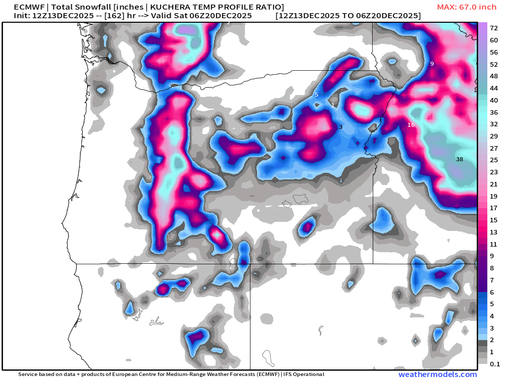
Below is a snowfall map going through Friday the 19th. I see a lot of snow totals higher than two feet! 🙂
Okay, have a wonderful rest of your evening, and a great Sunday!
