
We basically have three separate storms rolling through our region, but these storms are very small, and the energy with them is sort of splitting. What does that mean for us? Well, I thought about writing a whole paragraph trying to explain it, but let’s use some visuals instead. 🙂
This first image shows what a healthy consolidated jet stream looks like. This is from last week when we experienced strong gusty winds and heavy showers.
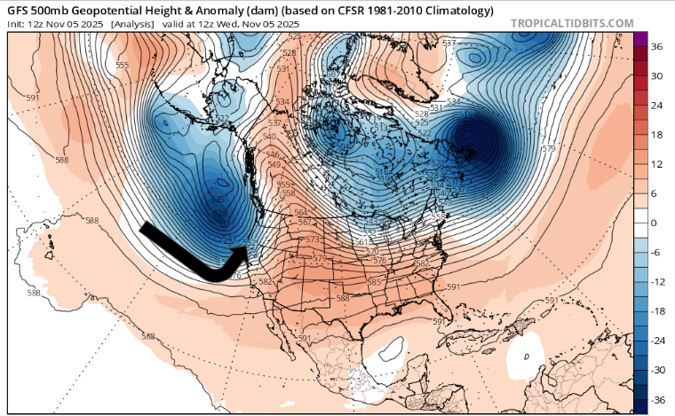
Notice the nicely packed lines butting up right into Oregon (indicated with the arrow). This consolidated jet stream directs most of the energy in the atmosphere into the same spot allowing stronger storms to develop. Think of this stronger and more consolidated jet stream as like being a train directing all of its force into one location. Now, take a look at the forecasted pattern for this Thursday.

What a mess! There are three separate pieces of energy hitting the west coast. This splits up the energy resulting in several weaker storm systems versus one large consolidated storm. Think of this setup as producing a bunch of spinning tops. Compared to a train, there is very little weight or force behind these spinning tops making it tough to forecast the details of where showers will hit, when they will occur, and how much rainfall will fall at any given location.
Forecast
Expect showers at times Thursday through Saturday with sunbreaks mixed in between. Best chance for dry weather during these three days will be on Saturday. By Sunday, the jet stream will sort of have its act together and should deliver a slightly stronger cold front to the region.
I see no strong winds, prolonged heavy rain events, arctic blasts, snow, or ice storms on the horizon for us. The next 7 days look pretty calm – just a little wet at times. Maybe a stronger storm next Thursday, but plenty of time for those details later.
Enjoy the rest of your week!
