
Showery and cooler weather is upon us, and today’s weather definitely gave off cozy stay at home vibes. The image below shows the weather pattern at 500mb (18,000 feet up into the atmosphere) valid for this Tuesday evening. In general, the deeper blues indicate much colder than normal temperatures for that altitude, and the red/orangish colors indicate much warmer than normal temperatures. I have added an arrow pointing to Oregon, and a white “L” to show the center of the low pressure system giving us rain and showers this week.

You can also see the hurricanes off our our nation’s east coast which will fortunately turn away from the mainland – excellent news!
The next image is a fresh 7 day forecast. I like the visual and will try to use this one more often during this upcoming fall and winter season.
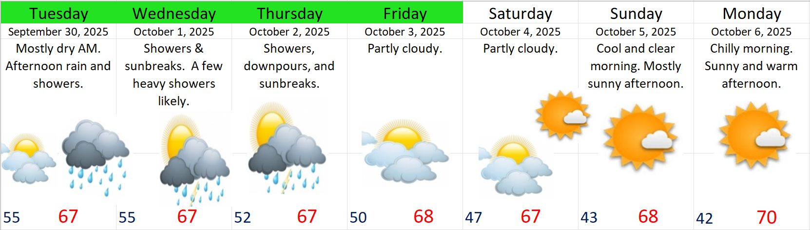
Details
Tue: A mostly dry morning. Increasing clouds with rain arriving during the afternoon. Wind gusts of 25 – 30mph. Not super strong, but stronger than we have seen in awhile…
Wed: This day really seems like a classic shower and sunbreak type of day with the weather changing throughout the afternoon. Warm sunbreaks will destabilize the atmosphere leading to downpours. Brief gusty winds 25 – 30mph possible at times.
Thu: Similar weather to Wednesday in that we will have both an unstable atmosphere & a few disturbances riding through the region. Expect additional downpours with sunbreaks mixed in.
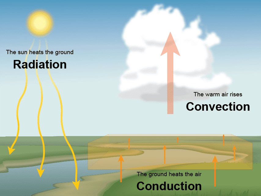
As we head further into our wet season, you will hear the phrases “unstable atmosphere” or “convection,” from time to time, and I thought now is an excellent chance to remind people what those things mean. An unstable atmosphere usually indicates that there is cold air up above us (aloft) with warmer air near the surface and plenty of moisture around. Solar heating from sunbreaks warms the moist air near the surface causing it to rise. These rising columns of air eventually cool and condense leading to the formation of clouds, showers, and thundershowers. It’s this process of convection which drives a lot of these heavy downpours of both rain and hail during this cooler time of year. So now you know!
Friday: Partly cloudy and dry.
Sat & Sun: Partly cloudy Saturday, and mostly sunny Sunday. Both days should be dry.
Next Monday – Wednesday: Chilly mornings and warm and sunny afternoons. Lows in the low 40s and highs 72 – 75°.
Have a great and safe rest of your week!!
