
Greetings! It’s been awhile since the last update. Had a busy, but really fun weekend sneaking in some camping before summer weather comes to an end, and I hope you all had a great weekend too! I’m back in the saddle again with a quick update covering the rest of our week. 🙂
Highlights
- Scattered downpours likely this afternoon through Tuesday evening.
- Some of these downpours could produce lightning and thunder.
- Plenty of sunbreaks and dry times in between.
- We dry out with partly to mostly sunny skies Wed – Sat.
- Shower chances increase again on Sunday.
Details
For the rest of today through Tuesday evening the Willamette Valley will be under the influence of an upper level low. This low will produce scattered showers of varying strength. Due to the scattered nature of these showers, most locations should experience plenty of sunbreaks during the in between times.
These showers have the potential to be very heavy with lightning and thunder also being possible. Some of these showers, especially the ones which pop up Tuesday, could be slow moving resulting in localized downpours. It’s virtually impossible to know exactly where the showers will pop up in this type of pattern; however, I’m confident by this time Wednesday a few of you will have picked up some hefty rainfall totals (more than half an inch). The map below shows the estimated radar for 6pm Tuesday evening, and illustrates the potential for scattered storms fairly well.
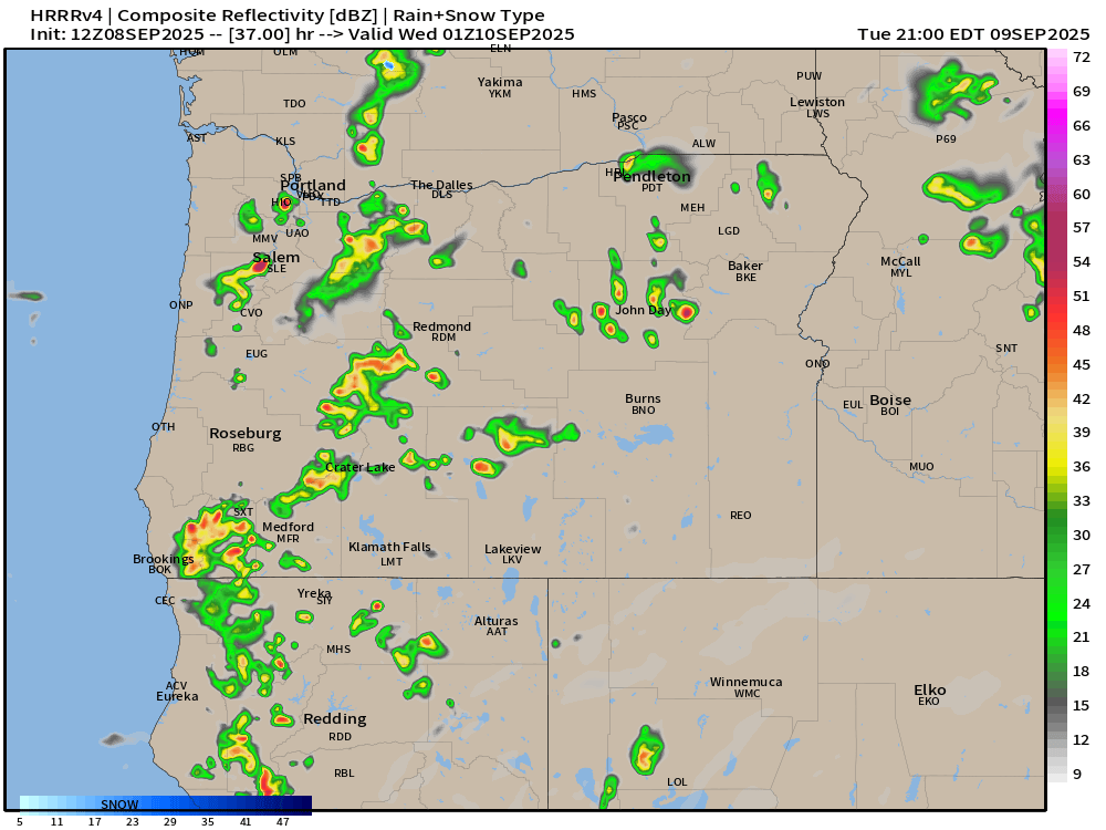
This forecasting tool is advertising several extremely heavy scattered showers dotting the Willamette Valley between Corvallis and the Portland metro. Notice not everyone gets a huge storm or soaking, but if a storm happens to move across your neighborhood then it becomes a pretty big deal.
The Willamette Valley dries out Wednesday, and we stay dry through Saturday. Our next threat for showers doesn’t show up until Sunday. Highs in the mid 70s Wed – Fri. Highs reaching the low 80s on Saturday.
The Cascades and central Oregon
Showers and thunderstorms remain possible in the foothills and Cascades each afternoon and evening through Thursday. As this upper level low slowly moves eastward, central and eastern Oregon will also experience some very heavy thunderstorms. Everywhere from Klamath Falls up through Bend and out over to La Grande can expect big soakings coming up this Wednesday and Thursday!
Most mountain locations finally dry out for both Friday and Saturday.
There you have it! Enjoy whatever heads your way and stay safe out there!
