
For those of you crunched on time here’s the forecast:
- Slight chance for showers and thunderstorms Tuesday afternoon through Wednesday.
- Dry Thursday through most of next week. Highs in the 80s and lows finally back down into the upper 50s.
- Slight chance for drizzle Saturday morning; otherwise, a warm and dry weekend.
- Highs in the low 90s again next Tue – Thu, but with cooler nights (upper 50s to near 60°).
Details
We have two clashing forces at work affecting our nighttime lows: longer nights and cloudy/muggy conditions.
Yes, it is still summertime, but our sun angle is steadily lowering and it’s noticeable too. Salem has always lived in the shadow of Portland, and I could not find a graphic like the one below for Salem. Honestly though, in the scope of things the information is about the same.
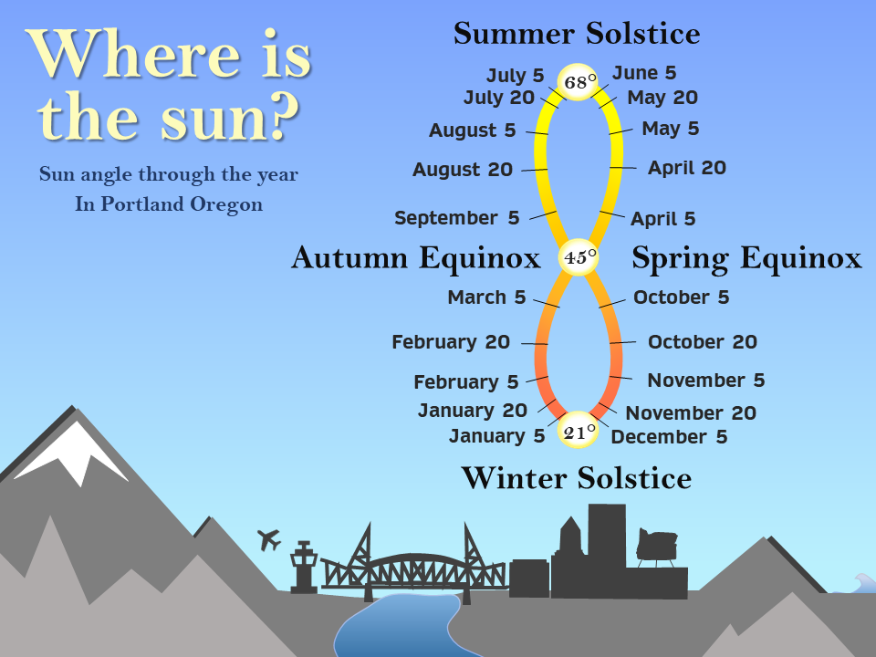
At this point in the year the sun angle is about what it would be during mid April, so despite the very hot regime we are in at the moment, it will continue to become tougher and tougher for our temperatures to stay uncomfortably warm at night. Take for example the temperature swing from this past Friday afternoon to early Saturday morning. The temperature dropped exactly 40 degrees from 101° all the way down to 61° in just 14 hours. That’s impressive, and it’s a testament to both the very dry airmass we had in place to begin this heatwave, and the longer nighttime hours.
Countering that factor is the increasingly humid atmosphere and cloudier conditions which have been moving in. It’s true the clouds during the daytime hours limit heating some, but they also make it tougher to cool off at night. The morning low bottomed out at 64° here in Salem. Expect lows to remain above 60° through Thursday.
Another item to watch this week is a small disturbance in the atmosphere expected to drift from south to north directly over us Tuesday afternoon through Wednesday evening. At any point during this timeframe scattered showers and even a few thunderstorms could pop up anywhere west of the Cascades including the coast. The chances are not real high, and some of us will stay dry here in the valley, but keep this in mind as you’re out and about. Storms will generally be much more widespread over and east of the Cascades now through Wednesday night.
Below are images from two different forecasting models showing how isolated the storms and showers are going to be, and how tricky it is as forecaster trying to decide who to forecast which areas get storms and which areas don’t. This first image shows scattered showers running in a line just north and east of Salem extending all the way out to Astoria.

This second one does not have labels, so I added a small blue circle where Salem is located at. Again, only some of us here in the valley will see storms with this model thinking the central Oregon coast will be the place to be.
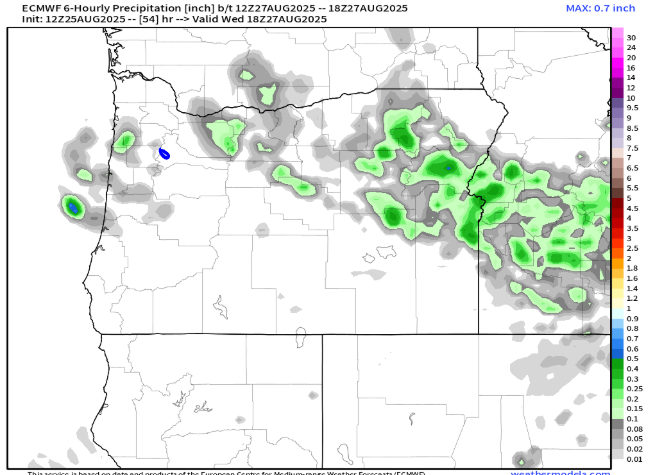
I share these images from time to time in my forecasts with the purpose of illustrating how tricky it can be to forecast scattered showers/storms. Don’t fixate on the exact locations in the maps above. Just focus on the general idea knowing that storms are a possibility anywhere Tue & Wed, but not everyone is going to be effected by them.
We have a slight chance for some light drizzle Saturday morning, especially northwest of Salem. Otherwise, plan on a warm and dry weekend.
Next week the warm weather continues with highs in 80s to low 90s Monday through Friday as we begin September. Lows should be cooler this time around staying in the upper 50s at least.
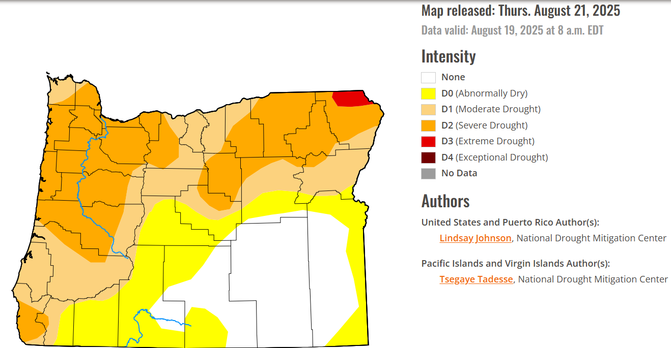
Drought update
Many of you have probably noticed we have been dry, and it’s true, we are running below average for precipitation across much of the state of Oregon, and the drought monitor map reveals this well:
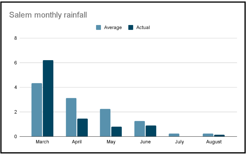
We have lacked significant rainfall which is not uncommon for summer here, but what is a little uncommon is we have seen drier than average months since April. The chart below shows monthly precipitation for Salem going back to March which was the last time Salem had a wetter than average month.
It’s nothing to be too worried about, but something I’m keeping an eye on and will update you as we get closer to fall. Typically, fall rains easily erase any drought fears left behind from a dry spring & summer.
Take care and happy Monday!
