This will be a very short post, but an important one. I’m confident a winter storm will impact our region beginning Thursday morning through at least Friday morning. I’ll have a nice post filled with more details and shiny graphics tomorrow. For now, plan on weather disrupting your daily routines beginning Thursday morning with rough travel conditions lasting through at least the first half of Friday. This means snowy and icy roads during this period of time – even during the daytime hours on Thursday.
The situation this time is much more simple compared to last week which is why I have such high confidence two days out. We are not dealing with isolated showers, the timing does not have to fall in the middle of the night, and we don’t have to worry about southerly winds. We will be plenty cold, and moisture will be abundant with chilly breezes continuing out of the north for the duration of this event. The perfect recipe for wintry weather.
How much precip will fall, and what form of frozen precip will we experience are the two big questions still up in the air. At the moment it looks like the Salem area will see a mix of snow, sleet, and freezing rain through the course of the storm. Temperatures will be below freezing all day Thursday through at least Friday morning, so accumulations will occur on the roads. My best guess would be 1 to 3 inches of snow, some sleet, and a little bit of freezing rain. Keep in mind forecasting snow totals is tricky when we are bouncing back and forth between snow and ice.
Friday afternoon or for sure by Saturday morning we should warm up to begin the melting process. It’s mid February, so the snow and ice won’t stick around super long, but for the two days it’s here, it will effect your life to a degree.
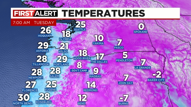
Happy Tuesday and stay safe out there. I leave you with a map of the regional temperatures as of 7AM this morning. Brrrrrrr!!!!!