
This past Wednesday was an exciting day. I would guess that everyone at least saw snow in the air. It did not stick in most places, but some neighborhoods got a brief coating of white, and the higher hills around town received accumulating snow. These showery patterns with southerly winds are always so borderline. So many factors to consider which really can’t be forecasted very well far in advance. Had we been two degrees colder, or had the showers arrived earlier while it was still dark then we could have woken up to a snowy or more like slushy winter wonderland. We’ve seen it go both ways here. Overall I’m fairly happy with how the forecast has gone. Hopefully I’ve portrayed just how tricky forecasting snow with this particular setup really is.
The forecast
A few very isolated showers tonight through early Monday morning, and by isolated I mean extremely isolated, but it’s just enough to keep us from being totally dry. I greatly dislike when the weather does that lol… Because of the showers, we also have increased odds of icy streets or even a random (light) dusting of snow – especially in the higher hills. Watch out for icy roads the next few nights and mornings.
Monday – Wednesday
Count on it being cold, but mostly sunny and dry. Lows in the lower 20s by Wednesday morning. This part of the forecast feels pretty certain to me. Highs will gradually cool off each day under the influence of a NE breeze.
Mon: Low of 28°. High of 44°.
Tue: Low of 24°. High of 42°.
Wed: Low of 21°. High of 39°.
Looking ahead
This coming week has the potential to be even colder with a more classic setup for widespread snow or ice. The ingredients will be in place. Cold air, winds out of the north and east, and a low pressure approaching from the southwest. This exact setup is how we get our biggest snow and ice storms. Some examples of this setup in the past include last January, the ice storm just before Christmas 2022, the big ice storm we saw in February 2021, and the snowstorm we saw (for you old timers like me haha) way back in December 2016. These are all examples of this “classic setup.” No southerly winds, no scattered showers like we have seen this week. Just cold air and steady precip. Still not an easy forecast, but several of the trickiest factors are removed from the equation in this scenario.
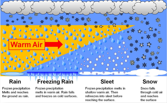
The first factor yet to be determined is how deep the cold air will be. If the cold air is shallow, we end up with more sleet or freezing rain – something we have seen more often these past several years it seems. If the cold air is deeper then we have the potential for widespread snowfall. I like to share the graphic below to help illustrate this point.
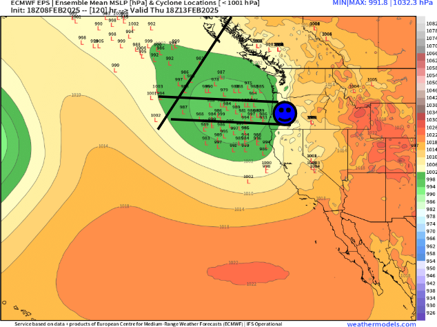
The track of the low pressure next week will also determine the impact on us locally. Too far south and we stay dry and cold, too far north and we see all rain or freezing rain, but if it goes somewhere in the middle then we end up with a nice snowstorm. I’ve drawn a few lines on the map below. This map shows low pressure (storm centers) for Thursday morning. Ignore the lows to west of the slanted line as they are part of another storm system. I’ve placed a blue smiley face to mark western Oregon hehe. In a nutshell, lows to the north of the top horizontal line would generally give us either rain or a brief shot of freezing rain or snow before changing to rain. Lows to the south of the bottom line would for the most part leave us high and dry, and finally, the majority of the lows between the two horizontal lines would give us a snowstorm.
So you can see why making a call on how much snow, or if it will even snow is not really possible just yet. History tells me that by Monday evening I should have a much better idea of what to expect.
We do know that it will be cold for the next several days. Again, keep an eye out for icy roads and parking lots, and have a fun and safe rest of your weekend! I’ll be sure to keep you all in the loop once details become more ironed out.
