
It’s late Tuesday evening, and time for a quick update.
Highlights
- The amount of locations receiving snow tonight will go up dramatically compared to the past couple of nights/mornings.
- Not everyone will see snowfall.
- I’m going with nothing to 3 inches.
- We could see snow showers on and off all day long, but the snow won’t stick during much of the day due to southerly breezes kicking in and “warming” us up to the upper 30s.
- Roads will be clear most of the day.
- As the winds calm down and the showers hang around Wednesday night which could give us a second round of sticking snowfall heading into early Thursday morning.
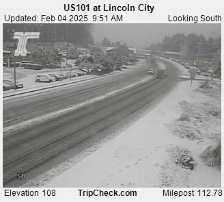
The main message is that moisture is dramatically increasing tonight through Wednesday night. Between now and roughly 10am anyone could see a coating of snow in their neighborhood. Our main issue the past two days with seeing snow is just a lack showers making it into the valley. Meanwhile, the coast has had no problem at all picking up a few inches of snow each day. These two images from the central Oregon coast show snow in Lincoln City and near Cape Kiwanda today. Pretty cool to see snow like this along our coast!
Tonight that is changing. Heavier and more numerous showers are set to move ashore overnight while we are cool and lacking a strong southerly breeze. This means anyone could see up to 2 or 3 inches of snow, but these are showers still, and I doubt everyone will get snow tonight.
It could snow all day tomorrow, but it likely won’t be sticking once we get past about 10am Roads should clear up quickly making travel tomorrow easy.
Wednesday night into Thursday morning could bring yet another round of snow showers as winds relax and cooler air moves back in. I hope to have a more detailed forecast tomorrow, so stay tuned!
Enjoy the snow and stay safe!
