
It’s been a quick minute since I’ve had a good chance to write up a forecast. I suppose if snow had been imminent I might have found time, but it’s been a pretty calm couple of weeks weatherwise.
Looking ahead it seems obvious we will stay in a calm weather pattern for at least the next 8 days. The grey skies and low clouds which have dominated our weather will give way to mostly sunny skies by Friday afternoon with sunshine lasting through at least Monday.
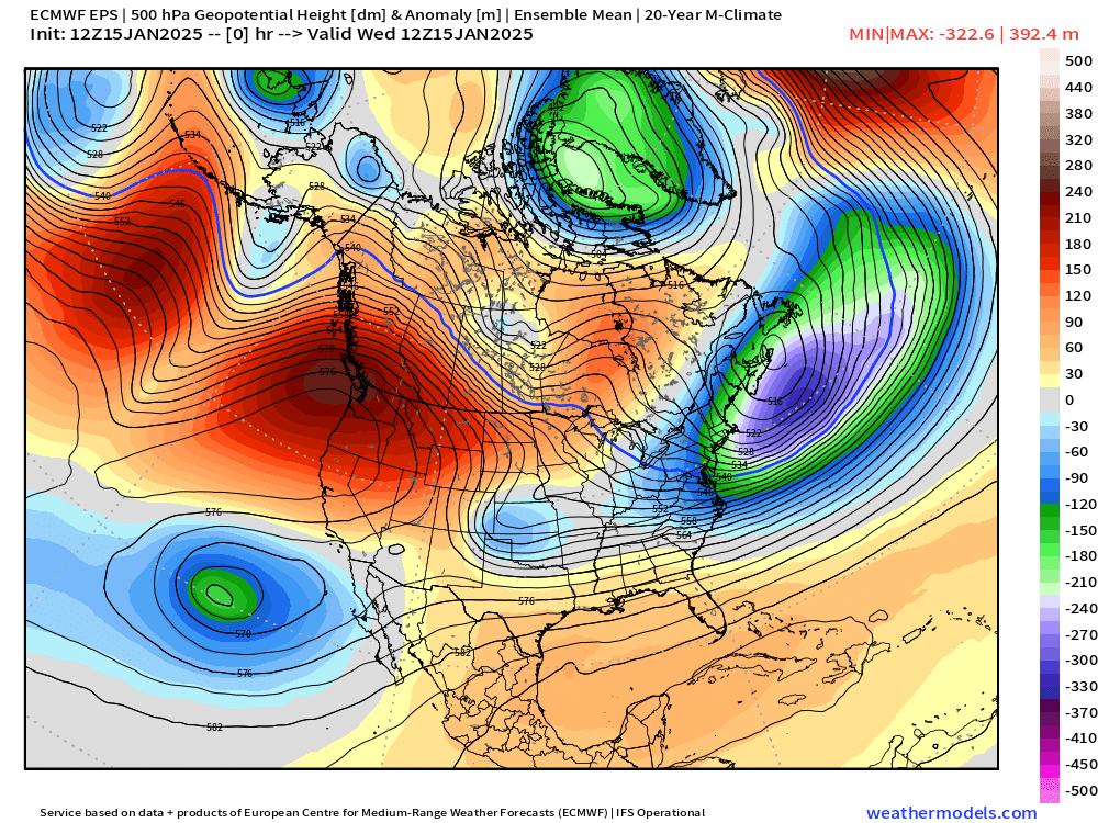
Over the past few days we have been in a pattern some people call “fake cold.” Regardless of what type of “cold” it is, the feeling on your skin is very much the same lol. This type of pattern would actually bring us very warm temperatures during spring or summer, but the low sun angle and long nights keep us cold down here in the valley below the layer of clouds and fog thus the name “fake cold.” This chart is a look at height anomalies for this time of year around thirty thousand feet up in the atmosphere. Basically Oregon is directly under a very warm ridge of high pressure.

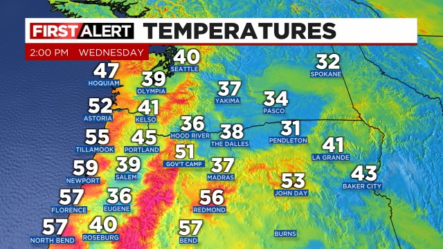
While we sat in the upper 30s under a chilly blanket of fog and low clouds these past few days, locations in central Oregon and along the coast have been soaring into the mid to upper 50s thanks to the warm atmosphere up above. Check out the 2pm temperatures from today.
The forecast
This weekend a frigid and deep arctic air mass plunges into the center of the nation. Temperatures will fall below zero in many locations in the upper midwest. Check out the forecasted morning lows for this coming Monday. Lows in the upper 20s to 30 right along the Gulf of Mexico even. Brrrrr! Click the image for a closer look.
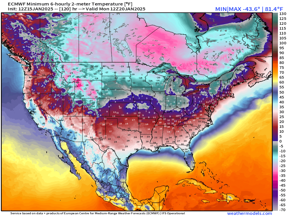
Oregon just gets brushed by this arctic blast. You can see the cold air encompassing much of the country by Sunday night with Oregon right on the edge of it.

The result is we dry out, turn sunny, and temperatures will drop a bit. Lows will be in the low to mid 20s. Even with full sunshine, highs will gradually cool off each day. Something I’ve observed during similar events in the past is how the colder airmass gradually takes hold – in part due to the long nights slowly helping us too cool down more than the previous day. You can notice the downward trend in the temps from Friday through Monday.
Thu: Mostly cloudy with lows that morning around 34° highs around 45°.
Fri: Sunnier with a low of 31° High of 46°
Sat: Mostly sunny and dry. Low: 29° High: 44°
Sun: Sunny. Low: 26° High: 43°
Mon: Sunny. Low: 23° High: 40°
Tue: Mostly sunny. Low: 23° High: 40°
Wed & Thu: Partly cloudy. Lows in the mid 20s and highs in the low to mid 40s.
Bottom line is it will be sunny and beautiful outside, but it’s going to be very cold.
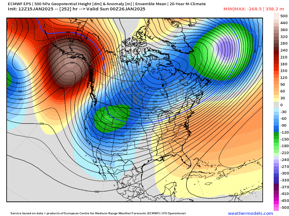
Looking further ahead past the 23rd, I see what appears to be our first real shot at even colder (and possibly snowy) weather. Still too far out for details or specifics, and things can always change, but I wouldn’t be mentioning it if there wasn’t at least a decent chance of it happening. The next chart is for Saturday evening the 26th. Yes, it’s a ways out, but it’s something I’m watching for. This shows the pacific northwest entrenched in very cold air. At the moment, many of the major weather models agree that a batch of cold arctic air could be paying us a visit later in the month, but stay tuned for more details.
The trickiest part of forecasting cold and snow here is that if the cold airmass pours out over the ocean too far from us then we just get a chilly rain. If it slides to the east, then we just get more sunny and cold days (like what we have in store this weekend), with no snow. The cold air really has to come down almost directly over us for things to get real interesting.
I’ll keep watching for trends or changes to the forecast. In the meantime, stay safe and stay warm out there!
