After more than ten days of dry weather, rain finally returned Saturday. Showers with a few sunbreaks are on tap for the rest of today. We dry out Monday through Wednesday. A weak storm on Thursday, and then a stronger storm likely for next Friday night and Saturday. Details below.
Details
Today: Showers with brief sunbreaks in between. Highs in the upper 40s to near 50°.
Mon – Wed: Fog and low clouds are likely each of these days. Highs will vary though depending on fog. Best guess would be near 40 give or take a few degrees. Lows Tuesday and Wednesday will be in the 28 to 32 degree range .
Thu: Dry start and then rainy and damp in the afternoon. Lots of cloud cover and chilly. High 45°.
Fri: A mostly dry day in between storm systems. Lows will start out near freezing thanks to the clearing skies, and highs will only reach the mid 40s. Rain moves in Friday night.
Sat: Watching the potential for a much stronger storm to impact the region this day. I’ll be watching closely with updates to follow. Right now, high winds along the coast seem pretty likely, but depending on the strength and track of the storm, strong winds could also impact the valley. Wintry weather in the Columbia River Gorge is another possibility with this storm, so stay tuned!
November 2024
In other (old news), November 2024 has come to a close, and here are the stats.
November was slightly warmer than average at 1.3 degrees above normal. November was also wetter than average despite the dry end to the month. We ended up with 7.17″ of rain which is 1.22″ above normal or 120% of average.
Nothing super remarkable happened in November. The highlights for our immediate region would be the early snowpack and start of the ski season. Other than that, nothing real big took place. We avoided the worst of the “bomb cyclone.” We also were spared the heaviest rain. Southern Oregon was not so lucky and experienced some flooding mid month.
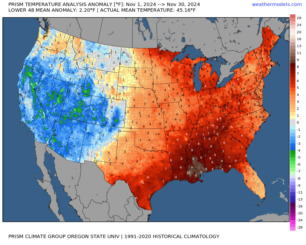
Overall a little warmer and wetter than average. At the national level, one can see that much of the country was on the warmer side with the intermountain region and southwest being the main exception.
How do we stand so far this December? Well, temperature wise it has very much flipped with the eastern US experiencing some extremely cold weather so far this month.
As a weather guy, something interesting I notice are the pockets of below average temperatures found out west surrounded by much warmer temperature anomalies. The Willamette Valley, some of the valleys east of the Cascades, and the Snake River Valley in Idaho are all running colder than normal due to the strong inversions we have been seeing. Meanwhile, the mountains around us have been warmer than average. Goes to show what some pesky fog and low clouds can do.
That’s all for today, but keep an eye out for a storm update later this week. Stay safe and healthy out there! 🙂


