
The heat is making its presence known today. Check out the toasty hot temperatures across the region as of 5PM.
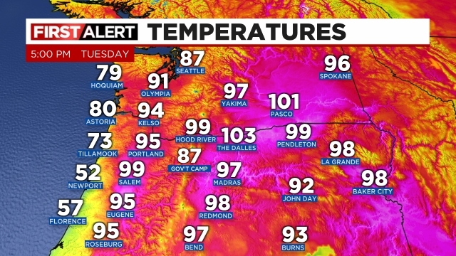
Note the downright chilly temperatures right along the immediate coastline – specifically Newport. The colder than average sea surface temperatures (due to upwelling) are making their presence felt there as well, just in a very localized manner. It’s just amazing to see a 47 degree difference between Salem and Newport.
Tonight through early Wednesday morning anyone could experience a thunderstorm. These storms have the potential to produce significant lightning which is fun to see, but terrible news for the dry forests. New fires seem almost certain to start from this. Hopefully more rain falls than is currently being predicted.
Speaking of predictions, take a look at this image showing the estimated radar for midnight our time. Avoid getting caught up in the details of the shower and storm locations. The main message here is scattered storms will develop and cross over the Willamette Valley tonight.

Highs for both Wednesday and Thursday will be in the mid to upper 80s. It will be nice to finally leave the 90s behind for a few days. Lows Wednesday morning may be held up higher due to cloud cover, but lows Thursday should drop down to around 55°.
Stay safe out there!
