
In case you are short on time, here are the most important headlines:
- The Salem area freezes up late Friday morning or early afternoon at the latest with snow showers turning roads snowy and icy.
- A major winter storm will effect us Friday night through Saturday night brining widespread snow and freezing rain along with power outages for many.
- Very cold (sub freezing) air remains in places through at least Tuesday or Wednesday of next week.
Details
We are closing in on what will be one of the largest winter storms we have seen in years. This storm will likely bring both ice and snow to the Salem area with an intense cold as well, and will continue to effect your life for several days to come.
Friday: This is important!! It is increasingly likely that Salem freezes over during the late morning or early afternoon hours. We will probably see snow showers here in Salem while the bitter cold arctic air begins to move in. Roads could turn snow covered fairly suddenly which will quickly make travel very difficult. Even if we don’t get snow initially, roads will turn icy as the temp drops. Our high temperature Friday will occur in a few hours when we hit midnight. Temperatures will continue to drop from there on out.
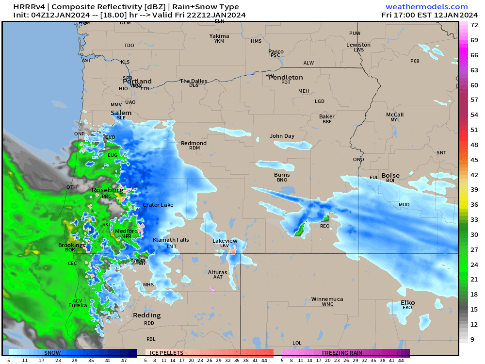
Here’s the forecasted radar for Friday at 2pm showing snow showers around Salem and even points south already:
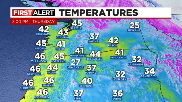
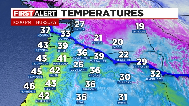
Check out the progress of the cold air. I have the 3 and 10PM temperature maps from the PNW. You can see the progress of the cold air advancing southwestward toward us with Seattle now under the influence of the arctic airmass.
Friday night through Saturday night: A major winter storm rolls across the entire region. Freezing rain, sleet, and snow will fall between Eugene all the way up to Portland and out along the coast even for locations north of roughly Waldport or Newport. Eugene and Newport up to about Lincoln City and Albany will probably be in the freezing rain zone most of the time. Albany, Salem and Woodburn will probably see a “good” mix of freezing rain, sleet, and snow. That will be a real mess!! North of Woodburn should mostly be snow the whole time. This storm should end during the overnight hours early on Sunday. Temps will hold fairly steady in the lower 20s all day long. That’s right, temperatures 20 to 23 degrees coupled with breezy north winds plus snow and ice falling all day long will make for the coldest day we have seen in years.
How much snow or ice? This is always tough as the exact depth of the cold air and how much moisture falls ultimately determine this, but here’s my best guess for Salem specifically. I’m thinking 2 to 6 inches of snow and a quarter of an inch to 3 quarters of an inch of freezing rain. In general, the more snow we get the less freezing rain we will receive and vice versa. If we end up getting more snow (like 4 to 6 inches), then we may avoid significant power outages here in Salem. Either way, Salem will be shutting down for a few days as roads will be covered with snow and ice.
This estimated radar image shows the various wintry weather precip types for Saturday at 11am. Blue is snow, and the salmon like color is a mix of snow and ice, and the purple represents freezing rain.

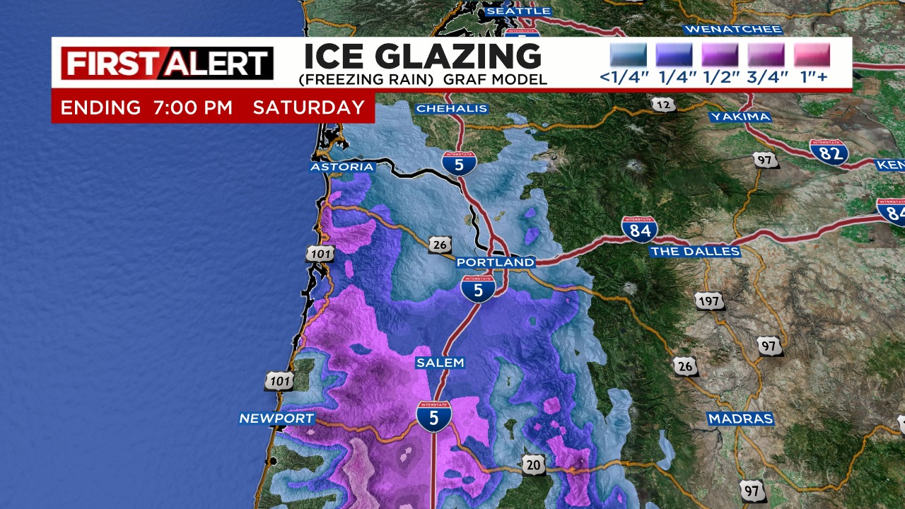
This next image shows estimated ice accumulation. Those purples south of Salem are totals over half an inch. Not good for those areas.
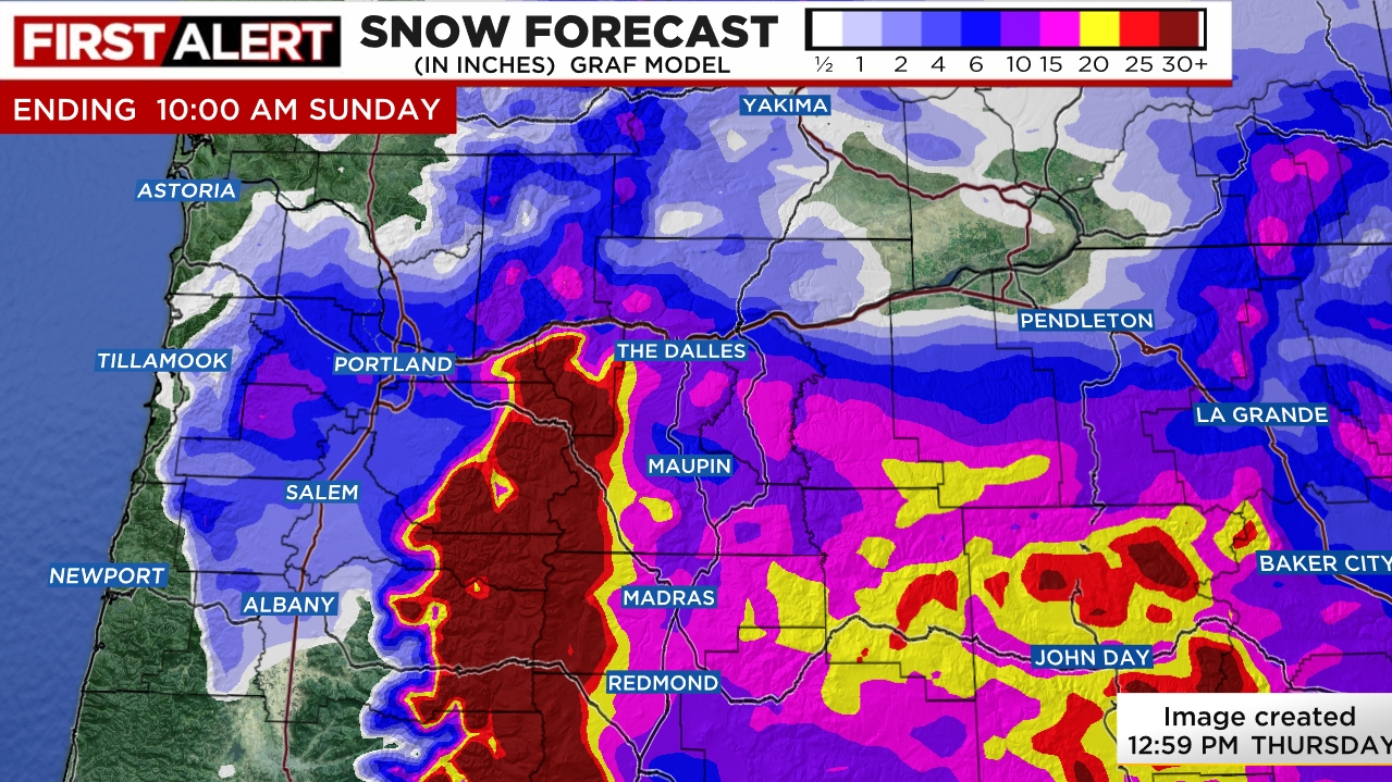
This next image shows total snowfall for the storm. This shows Salem receiving several inches of snow, but a small shift in things could give us either more ice or more snow. Put those maps together and you can see why we have a big frozen mess on the way!
Sunday: Frigid! Highs 27 to 29° Lows Sunday night into Monday morning 13 to 16°.
Monday: Clear skies and sunny and super cold. A high around 30 to 32° and a low temp Monday night around 10 degrees F.
Tuesday: We SLOWLY “warm up to freezing after an absolute frigid start to the day. Highs might even crack freezing this day, but not by much. I’m going with a high of 32°.
Hang on and stay safe!!!!!
