There is a lot going on in the weather world right now, and so much to cover. Phew! I’m both excited and exhausted just thinking about it all, so let’s begin!!
The forecast
The rest of today (Saturday): Showers, downpours, maybe a rumble of thunder, and a few more sunbreaks before night comes.
Sunday: A slightly sunnier version of today’s weather with a few more sunbreaks between showers. Really a not too bad of a day minus the occasional shower or brief downpour. High of 46°
Monday: Periods of light rain. High of 49°
Tuesday: An extremely stormy day with strong winds and heavy rain at times. Winds will gust up to 45mph which is strong enough to bring down a few branches or weak trees. Highs in the mid 40s.
Wednesday: More rain and showers with breezy winds of 20 to 30mph. Overall, a very stormy day and a chilly day too. Highs only around 42 to 45°.
Thursday: Chilly with showers and sunbreaks. Snow levels should stay close to 1000′ which means the higher hills around town could see some slushy snow during the morning hours. Highs 41 – 43°.
Fri – Mon (Jan 12th – 15th): As we stand right now, this entire stretch of days appears to have a pretty high chance for widespread snowfall along with very cold temperatures. Too far out to know specifics, so look for more details in updates to come. Currently, I’m calling for highs in the lower 30s with lows in the teens or 20s. I think most of us see at least 1 to 3 inches of snow at some point during this time frame, and don’t be shocked to see things change further. We will be dealing with a bitterly cold arctic airmass, and depending on how close it gets to us, we could be looking at some significant winter weather in terms of not only snowfall, but extreme cold as well. It could also warm up too… Just stay tuned for more updates in the coming days as a lot can change when we are looking 6 plus days out.
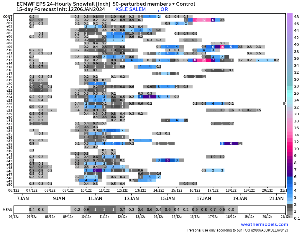
I rely a bit on charts like this one below to help with forecast confidence. The best way to look at this chart is to first notice the dates on the bottom. Time goes from left to right (just like how we read). Next, we have the horizontal lines which also are read from left to right. Each line represents a possible outcome in terms of snowfall for Salem. These are 24 hour running totals. The basic concept you should look for is agreement. The more horizontal lines showing snowfall around the same time frame, the higher the chance is we actually get snow. I’ll try and share an updated edition of this chart in a day or two to help compare and see if things are trending snowier or not so snowy. By the way, ignore the grays for the most part. I usually interpret gray to mean 1000 foot snow levels – so snow maybe in the hills, but not likely in Salem. Look for the blues, purples, and pinks.
The Cascades
As mentioned in the previous post, the Cascades are getting hammered, and will continue to get hammered with feet of snow by the time next week ends.
The Coast and Coast Range
Waves will peak in intensity Tuesday. Maximum wave heights look to be 35 to 45 feet that day along our coastline! Wednesday they should still be going strong coming in above 30 feet. The rest of the week should feature more typical wave heights, but with the “King Tides” later next week, the chance for coastal flooding is certainly higher than normal. Be extra careful if you are out along the beaches next week.
Meanwhile, snow could fall in the Coast Range both Wednesday and Thursday mornings. Travel over the Coast Range should be mostly snow free during the daylight hours though.
So much going on, and a ton of wild wintry potential, so look for more updates regularly as things unfold.
Stay safe, and happy weekend!!

