I hope you all are having a nice day and have enjoyed the nicer weather we have had lately. For too long we were locked into a chilly pattern which brought multiple chances for snow to the mid valley. Those snow events made for some challenging forecasts, and while I enjoy the snow and I’m happy with how most of the forecasts turned out, I’m glad to see nicer weather and a much needed break. 🙂
Of course it’s springtime here in western Oregon which usually means the breaks don’t last long, and indeed, our beautiful weather will come to an end this afternoon.
FORECAST
Today: Sunny until 4 or 5PM at which time showers and thundershowers will roll in from the west putting an end to our sunny and mild weather. In this particular pattern, the east side of the Willamette Valley has the highest chance of seeing downpours and thundershowers this evening; however, anyone could get soaked. Very hit and miss with the showers today, and that’s just the nature of this type of pattern. Whether you get a downpour or not, the mild weather will end today.
Thursday through Sunday
Expect the same type of weather all 4 of these days. Heavy downpours, sunbreaks, and hail showers. I’m also thinking anyone could see snow in the air (not really sticking that much) during the nights and early morning hours as cold air returns with this storm stystem. Locations in the higher hills outside of town have a better chance of waking up to a dusting of wet snow.
What seems more likely is significant hail accumulations. With an unstable airmass and very cold air aloft (up in the atmosphere), I’m thinking some of these downpours and thundershowers will drop quite a bit of small hail enough to briefly cover roadways which could lead to treacherous travel conditions.
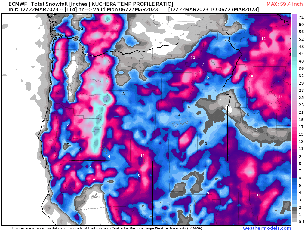
This map shows total snowfall in inches through Sunday evening. Both the Coast Range and the Cascades will see plenty of snow. The Cascades in particular should pick up some 2 to 3 feet of new snow with more on the highest peaks. This map also shows Salem getting about a trace of snow which in reality means nothing more than snowflakes in the air.
Again, there is a larger threat that hail could cover the streets and surfaces this week than snow.
Lows each morning will be 33 to 36 degrees and highs will likely stay in the upper 40s, and coupled with the hail and downpours, it should be a wild few days.
I’ll have an updated forecast later this week with any updates as well as a look at our spring break.
Take care!! 🙂

